Still here · DeKalb County · Dam inventory GA01333
Buena Vista Lake
An 8-acre county-owned lake inside Barker Bryant Memorial Park in Candler-McAfee, held by a 29-foot earth dam rated high hazard and satisfactory.
From the air
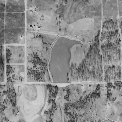
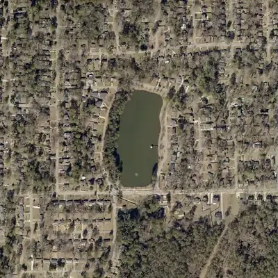
Buena Vista Lake and its road-top dam already existed in 1940, when this was farmland. The neighborhood was built around it by 1955, and the lake has barely changed since.
- First seen
- The lake is already full in the 1940 aerial photo, so it was built before then.
- Dam in the lidar
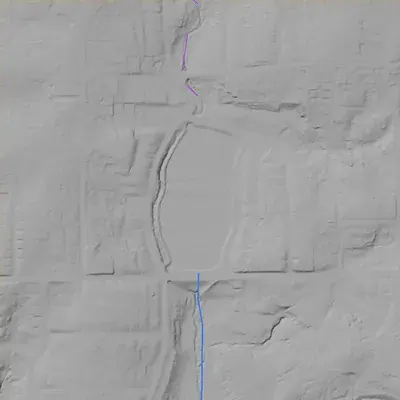
- The dam is the road embankment along the south shore. It stands about 28 feet high from the road to the stream channel below. The road on top is only about 2 feet above the lake surface. No breach was seen. Water leaves through or under the road at the south end; the spillway is uncontrolled.
Read from aerial photos taken between 1940 and 2026 and from DeKalb County 2024 lidar, then checked by a second reading. How the photos were read.
Depth
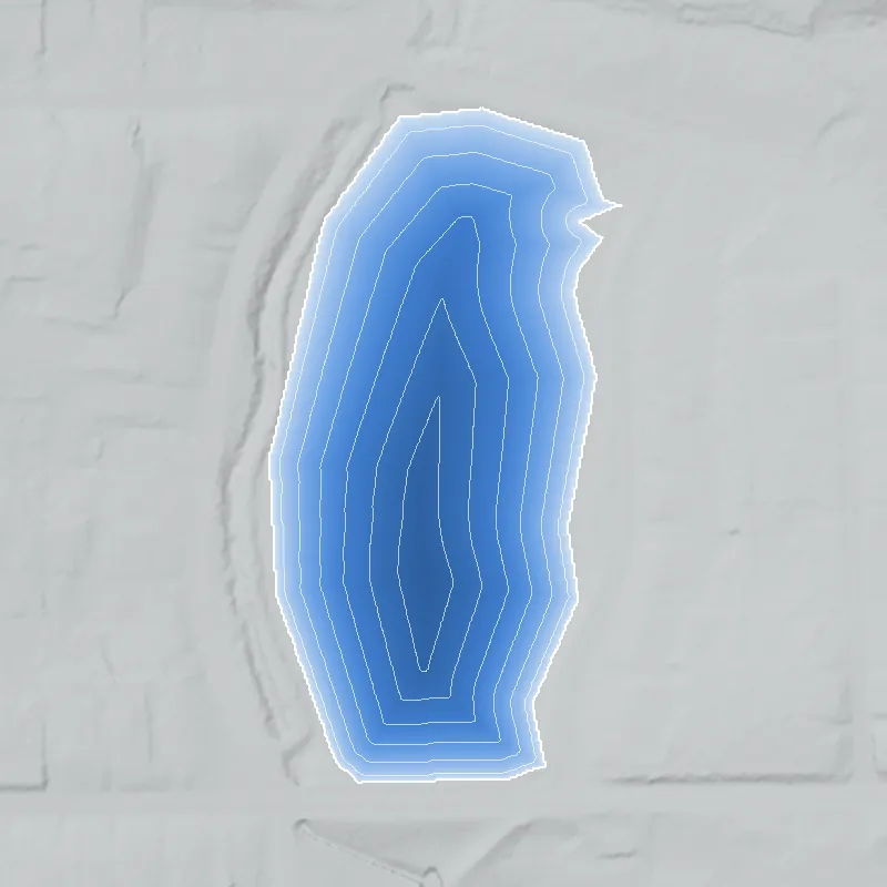
Modeled from the shoreline shape and the dam inventory’s average depth: deepest point about 14 ft. Treat it as an estimate; no survey of the lake bottom was found. How depth is estimated.
History
Buena Vista Lake is a small lake in southeast DeKalb County, off McAfee Road in the Candler-McAfee area. The USGS names it (GNIS ID 325886), and DeKalb County's mapped Barker Bryant Memorial Park boundary takes in nearly all of it. The National Inventory of Dams lists a 29-foot-high, 377-foot-long earth dam owned by DeKalb County, used for recreation, with 8 surface acres and 51 acre-feet of normal storage. Georgia's Safe Dams program regulates it as high hazard and last inspected it March 19, 2019, rating it satisfactory. No source found here names the builder, the construction date or the original purpose. 1234
Who built it
Not documented in the sources reached. NID gives the year completed as undetermined, the designer as unknown ('U') and the stream as 'U'. USGS hydrography shows no mapped stream flowing in from upstream, only a centerline through the lake. An unnamed channel about 0.87 km long leaves the dam end and runs southwest to join Doolittle Creek, so the lake sits at the head of a small tributary of Doolittle Creek. Whether it was built across a spring-fed draw or a longer stream is not established. 12
Timeline
- UnknownConstruction date not established. NID leaves the year completed undetermined and the designer unknown. Historic aerials or topo maps would show when the lake first appears. Uncertain 1
- 2007NID lists 2007 as a year the dam was modified. The nature of the work and contract are not stated. 1
- March 19, 2019Georgia Safe Dams inspection; the dam was rated Satisfactory and remained classed High hazard. 1
- April 20, 2021NID record for this dam last updated by the state program. 1
- September 23, 2026The NID national download of this date still lists the dam as DeKalb County owned, for recreation, High hazard, Satisfactory. 1
Names
- Buena Vista Lake Dam
- Name of the structure in the National Inventory of Dams. NID lists its city as 'Glenwood Hills', a locality label, not a documented lake name. 1
The dam
NID: earth dam, 29 ft high, 377 ft long, uncontrolled spillway and outlet, 51 acre-ft normal and 60 acre-ft maximum storage, 8 surface acres. Owner DeKalb County (Local Government). Regulated by the Georgia Safe Dams Program (state ID 044-023-00538). Hazard class High; condition Satisfactory; last inspected March 19, 2019, with a 2-year inspection cycle; an emergency action plan is on file; NID lists a modification in 2007. The NID drainage-area figure of 334 square miles cannot be right for an 8-acre pond at the head of a roughly 1 km channel and looks like a data error. High hazard rates the consequences of a failure, not the dam's condition. No contract numbers or engineering reports were found. 12
- Dam height
- 29 ft
- Surface
- 8 acres
- Average depth
- about 6.4 ft
- Stream
- U
- Owner type
- Local Government
Figures from the U.S. Army Corps of Engineers’ National Inventory of Dams. Its “year” is often a rebuild or survey date, and average depth is storage divided by area.
Around the lake
Water
The lake drains through an unnamed channel to Doolittle Creek, which USGS maps flowing on to Mountain Creek and then the South River.
Visiting
Getting there
County-owned public land. DeKalb County GIS lists Barker Bryant Memorial Park (2300 McAfee Rd, unincorporated DeKalb, about 9 acres) as public with long-term protection, and the lake lies within its mapped boundary. Park hours, fishing rules and whether the dam is reachable on foot were not confirmed; the county park pages tried returned errors.
What you can see
A small lake with an earth dam about 29 ft high and 377 ft long at its south end, and an uncontrolled spillway. Whether the spillway and dam face are visible from public paths is not confirmed.
Look, don’t dig. Parks, cemeteries and preserves are off limits to digging and collecting, and private land needs the owner’s permission to enter.
Open questions
- Who built the dam and when, and was it made for a park, a subdivision, or an earlier owner?
- Who was Barker Bryant, and when did the county acquire the park and lake?
- Why is the lake called Buena Vista, and is the name tied to a subdivision or street?
- What was done to the dam in 2007, and under what county contract?
- What is the true drainage area (NID says 334 sq mi)?
- Was the lake or park open to all residents in the Jim Crow era? No source found.
Know something? Write to hello@historyunderfoot.org. Family papers, photos and deeds often settle these.
Where to look next
- UGA Map Collection aerials of DeKalb County, 1938-1940, to see whether the pond exists before the postwar subdivisions (Digital Library of Georgia / UGA Libraries Map and Government Information Library, Historic Aerial Photography Collection)
- USGS topographic map editions for the Atlanta East and Stone Mountain area, comparing 1950s-1970s sheets for first appearance and name of the lake (USGS Historical Topographic Map Explorer (topoView))
- DeKalb County Board of Commissioners minutes and contracts for park acquisition and the 2007 dam work; county parks history for Barker Bryant Memorial Park (DeKalb County Clerk / Board of Commissioners records and DeKalb County Recreation, Parks and Cultural Affairs)
- Georgia Safe Dams Program file for permit 044-023-00538, including inspection reports and the emergency action plan (Georgia EPD Safe Dams Program)
- Newspaper mentions of Buena Vista Lake or Barker Bryant Park, including the park's naming (Georgia Historic Newspapers (Digital Library of Georgia) and DeKalb History Center archives)
- Subdivision plats for the Glenwood Hills and McAfee Road area, DeKalb County Superior Court plat books (DeKalb County Superior Court Clerk plat records)
Sources
- National Inventory of Dams, national CSV (data last updated 2026-09-23), record GA01333 Buena Vista Lake Dam U.S. Army Corps of Engineers
- USGS 3D Hydrography Program MapServer, waterbody layer 60 (Buena Vista Lake, GNIS ID 325886) and flowline layer 50 (unnamed channel to Doolittle Creek, GNIS 325923) U.S. Geological Survey
- DeKalb County GIS, Parks feature layer (Barker Bryant Memorial Park polygon, county-owned, public) DeKalb County GIS
- DeKalb County GIS, Parks, Recreation and Greenspace layer (Barker Bryant Memorial, 2300 McAfee Rd, 9 acres, public, long-term protection; Barker Bryant Expansion, 2309 Hillside) DeKalb County GIS