Still here · DeKalb County · Dam inventory GA01321
Candler Lake
Walter Candler's estate lake in Emory's Lullwater Preserve, reshaped in 1952 by Emory's account and dredged again in the mid-1980s.
From the air
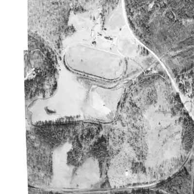
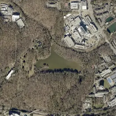
Candler Lake probably did not exist in 1940. Aerial photos show a pasture and a creek there, then a full lake with a wooded island by 1955. Its outline has barely changed since.
- First seen
- Between 1940 and 1955. The 1940 photo appears to show pasture and a creek, but it is overexposed, so a shallow pool cannot be ruled out.
- Dam in the lidar
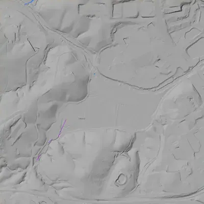
- Probably no tall dam. The best candidate is a low sill across the head of the north arm, about 150 to 170 feet long. Its crest stands only 1 to 3 feet above the lake. It is about 9 feet above the creek beyond it. This is low confidence, and no breach is visible.
Read from aerial photos taken between 1940 and 2026 and from DeKalb County 2024 lidar, then checked by a second reading. How the photos were read.
Depth
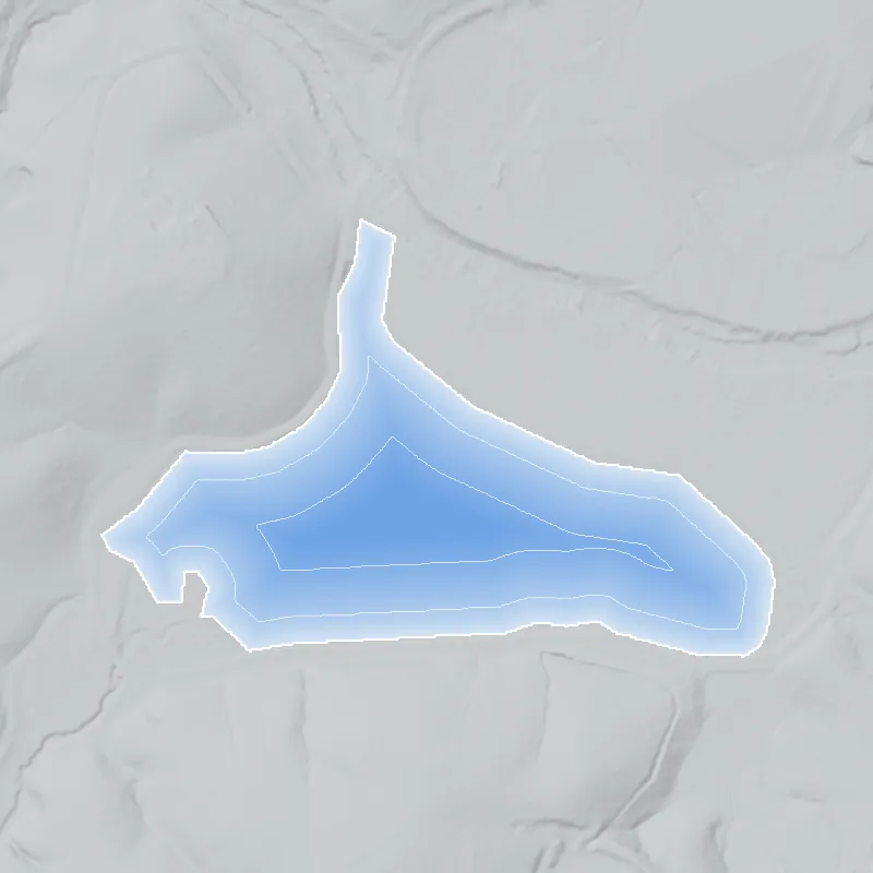
Modeled from the shoreline shape and the dam inventory’s average depth: deepest point about 5 ft. Treat it as an estimate; no survey of the lake bottom was found. How depth is estimated.
History
Candler Lake sits on Walter T. Candler's former Lullwater Farms estate, now Emory's Lullwater Preserve. Emory's management plan, citing a 1970 campus study, says the lake took its present form in 1952, when the creek was diverted and the old creek basin dredged; the National Inventory of Dams says 1955. Emory bought the estate in 1958 and named the water Lullwater Lake in 1961; it later became Candler Lake. Silt from a mid-1980s dredging was dumped behind a hillside dam that breached and washed back into the lake. Candler's 1925 powerhouse dam on the main creek is a separate structure. 1234
Who built it
Emory's management plan, citing a 1970 Emory study by Platt, says the lake in its present form was created in 1952 by diverting the creek upstream of the dam into its present channel and dredging the original creek basin. Emory's historian says that at some point after his c. 1930 estate photos Candler dammed Richardson Creek to make a lake filling a low pasture. The NID dates the dam to 1955. The plan says a cattle pasture surrounded the artificial lake. 123
Timeline
- 1820sLand lots in the Lullwater area are drawn in the land lottery. Naman Hardman buys two of the four lots overlapping the preserve and in 1826 deeds two acres for a meeting house, marked by the cemetery on the Clairmont Campus. 1
- 1876-1900W. J. Houston builds Houston Mill on South Fork Peachtree Creek in 1876 and converts it in 1900 into what the DeKalb History Center calls the county's first hydroelectric plant. Emory's plan places its relics just downstream of Lullwater. 51
- 1925-1926Walter T. Candler buys the rest of Houston's land (250 acres, per Emory's plan) and builds Lullwater Farms: the house, plus a dam and granite generator tower on South Fork Peachtree Creek to power the estate. He occupies the house in 1926. 6127
- 1920sEmory's plan says guests at Candler's parties had barbecues at a clubhouse on 'the lake (site of VA Hospital)' and watched boat races. That points to a water body at today's VA site, not clearly the present Candler Lake. Uncertain 1
- c. 1930Rose Library photos, dated by Emory's historian to possibly about 1930, show the tower, a wooden bridge over its dam, horses in pasture and, beyond a stream, a low pasture that the later lake would fill. Likely 2
- 1950Candler sells 43.5 acres for University Apartments. Civil engineer L. H. Fitzpatrick maps the Candler property, a survey Candler told Emory in March 1958 was still accurate. 1
- 1952The lake in its present form is created by diverting the creek and dredging the original creek basin, per a 1970 Emory study (Platt) cited in the management plan. The primary study was not read. Likely 1
- 1955Year the National Inventory of Dams gives for Candler Lake Dam. It differs from the 1952 date, and NID completion years are often estimates. Uncertain 3
- 1958Emory buys the remaining 183 acres of the Candler estate. The trustees' chairman says the property gives the university 'stretching room' for growth. 147
- 1960Members of the Emory community ask for recreational access to Lullwater, whose future use was still undecided. 1
- 1961Emory gives the house and lake official names, Lullwater House and Lullwater Lake. The lake's name later changes to Candler Lake. 1
- 1963President Sanford Atwood becomes the first Emory president to live in Lullwater House, and the first ground rules for use of Lullwater by Emory faculty, staff and students are published. 17
- 1966Three rhesus macaques (Macaca mulatta) live on the island in Candler Lake for a few months as an experiment reported in the Yerkes newsletter. They did not stay on the island. 1
- 1985-1986Candler Lake is dredged and the silt dumped behind an artificial dam on the hill above, authorized by President Laney against biology department advice. The dam later breaches and silt washes back into the lake and the research pond. The plan gives 1985 in a photo caption and 1986 in its chronology. 14
- 1985-1986The dredging and a five-acre land sale prompt professors William Murdy and Eloise Carter's report on the status of Emory's forested land. Emory's plan dates the report to both 1985 and 1986. 14
- early 1990sThe wooden bridge over the old powerhouse dam is removed because it had become hazardous. 2
- 2000-2002President Chace creates the Lullwater Task Force in February 2000. A joint committee produces a 2002 management plan that recommends repairing the north-end lake dam and the spoils dam and studying another dredging of the lake. 18
Names
- Lullwater Lake
- Official name given to the lake in 1961, along with Lullwater House. Emory's management plan says the name was eventually changed to Candler Lake. 1
- Candler Lake Dam
- National Inventory of Dams name for the structure (NID ID GA01321; Georgia agency ID 044-014-00208). 3
- Candler Lake (GNIS 00325891)
- Federal hydrography name for the mapped waterbody, about 0.063 sq km in the large-scale layer (0.045 sq km in the small-scale layer). 9
The dam
NID lists Candler Lake Dam as an earth dam 8 ft high and 165 ft long, with an uncontrolled spillway, 11 surface acres, 29 acre-feet normal storage and 65 acre-feet maximum. The owner is Emory University (typed 'Private'), the use is recreation, hazard is Low and condition is Not Rated. It is not state-regulated or state-jurisdictional. The NID record was last edited in 2021. Emory's 2002 plan says the dam sits at the lake's north end and needed repair to prevent a catastrophic flood of water and silt into the road and South Fork Peachtree Creek. No later rebuild, contract or drawdown record was found. 31
- Year in the inventory
- 1955
- Dam height
- 8 ft
- Surface
- 11 acres
- Average depth
- about 2.6 ft
- Stream
- Emory Banch
- Owner type
- Private
Figures from the U.S. Army Corps of Engineers’ National Inventory of Dams. Its “year” is often a rebuild or survey date, and average depth is storage divided by area.
Around the lake
Water
Candler Lake is a small lake beside South Fork Peachtree Creek, which NHD maps along its north and east edge. Emory's plan says the lake and streams are harmed by stormwater from Starvine Way, Woodruff Hall, Druid Hills High School, Clairmont Campus and Yerkes, plus road and parking-lot runoff, and by silt from the 1980s dredging.
Civil War
Emory's plan says Hardman's Church, at the cemetery site on Clairmont Campus, was destroyed by General Sherman's army, and that Sherman had headquarters near Clairmont Road. That is the plan's claim, cited to a 1998 research paper and a 1983 paper in the DeKalb archives, and I could not corroborate it. The DeKalb History Center says W. J. Houston's family lived at the Powell homeplace on Clairmont Road during the war.
Segregation
No record ties the lake to segregation. Context only: Emory opened Lullwater to its own community from 1963, and Emory's integration followed a 1962 Georgia Supreme Court ruling (Wikipedia, so treat as a lead).
Before 1861
Emory's plan calls Lullwater hunting grounds of the Cherokee and Creek nations, though its chronology says settlers took the land 'from the Cherokee nation' and cites no source for who held this specific land. The 1820s land lottery and Hardman's 1826 meeting house followed. Hardman's sawmill stood at the site later used for Houston's grist mill.
Visiting
Getting there
The lake is inside Emory University's Lullwater Preserve. A trail-guide site (page updated October 2025) says access is limited to Emory students, faculty and employees, with no parking at the trailhead. Emory's 2002 plan described use by the general public too. I could not reach an Emory access page, so check with Emory before visiting. Lullwater House is the president's home, so stay clear of it.
What you can see
The lake with its island and a dam at its north end. On South Fork Peachtree Creek nearby are the octagonal stacked-stone powerhouse tower, a spillway waterfall and a wood and steel footbridge. Lullwater House stands on the hill above. Emory describes the original spring-fed swimming pool and bathhouses as surviving.
Look, don’t dig. Parks, cemeteries and preserves are off limits to digging and collecting, and private land needs the owner’s permission to enter.
Open questions
- Was the lake built in 1952 (Emory's plan, citing a 1970 study) or 1955 (NID)? No construction record was found.
- The plan places a 1920s lake clubhouse with boat races at the site of today's VA Hospital, next to Lullwater. Was that an earlier pond, and is it the same water body as Candler Lake?
- Are the tower dam on South Fork Peachtree Creek and the north-end lake dam two structures? Emory's photos suggest so, but the NID drainage area of 23 sq mi looks like the main creek, and the NID area (11 acres) differs from the mapped 0.063 sq km (about 15.6 acres).
- Was the north-end dam repaired or the lake dredged again after the 2002 plan? No public record was found.
- Emory's plan says Candler bought 250 acres in 1925-26 and Emory bought 183 acres in 1958; Emory's historian calls the estate 183 acres from the start. The 43.5 acres sold in 1950 only partly explains the difference.
- Is the public still admitted to Lullwater? Only a third-party trail site was found, with no current Emory policy page.
Know something? Write to hello@historyunderfoot.org. Family papers, photos and deeds often settle these.
Where to look next
- Candler Collection, Folder 4, cited by the plan for the 1961 naming record and 1920s estate life (Emory Woodruff Library special collections (now likely the Stuart A. Rose Library))
- 'A Report on the Walter Candler Property,' Feb. 25, 1960, and the L. H. Fitzpatrick survey cited in the March 1958 letter (Emory Office of Business Management)
- Emory Alumnus, Nov. 1958; Emory Wheel, Oct. 16, 1958 and Apr. 28, 1960; Suburban Gazette, Nov. 12, 1958 (Woodruff Library Special Collections)
- Platt et al., The Quality of Emory's Natural Environment (Oct. 1970), the source of the 1952 lake date (Emory University (plan cites environment.emory.edu/ecology/1970.shtml))
- Yerkes Newsletter, Vol. 3 No. 2, Dec. 1966, 'Monkey Island' (Woodruff Library Special Collections)
- 'Lullwater Farms' files, including Funderburk in Brookhaven Buzz (Aug. 1994) and Gwin in the Atlanta Journal (1972) (DeKalb History Center archives)
- Murdy and Carter, 'Status of Forested Land of Emory University' (1985 or 1986) (Emory University)
- 1938-40 UGA DeKalb aerials and 1949 GSU Atlanta aerials, to check for a lake, clubhouse or earlier pond before 1952 (UGA and Georgia State University libraries)
- USGS topographic editions (1950s to 1970s) for the lake outline (USGS topoView)
- Emory Report and Emory Wheel articles, 1985-86 (dredging) and 1994-97 cleanup (Emory Libraries digitized newspapers)
Sources
- Lullwater Comprehensive Management Plan (chronology, streams/lake section), Dec. 2002 Emory University (Lullwater Task Force / Committee on the Environment)
- Never-before-seen photos! (Emory Historian's Blog, Jan. 31, 2017) Emory University Historian (Gary Hauk)
- National Inventory of Dams record GA01321, Candler Lake Dam (NID CSV service, data updated 2026-09-23; record edited 2021) US Army Corps of Engineers
- Early History 1836-1998, Emory, its Environment & Sustainability History Emory University Libraries
- Houston Mill House, built by H.J. Carr DeKalb History Center
- Emory History Minute: Lullwater Tower Emory News Center
- Lullwater House Wikipedia
- History, A Guide to Lullwater Park Student-authored blog citing Emory sources
- National Hydrography Dataset waterbody and flowlines (GNIS Candler Lake 00325891) USGS National Map