Status unknown · DeKalb County · Dam inventory GA01789
Charles Lake
A 7.5-acre private impoundment near Rock Chapel Road in Stonecrest; federal dam records call it Charles Lake, while USGS names list it as Davidson Lake One.
Watermark
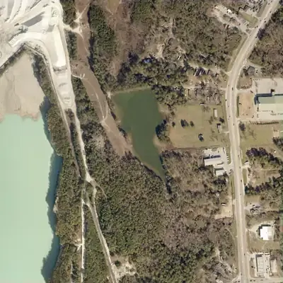
Charles Lake, full in 2017
A private lake behind a 22-foot earth dam near Rock Chapel Road, about 7.5 acres and roughly 32 acre-feet of water. It held water from the 1950s, was empty in 1972, and was full again by 1981 through 2017.
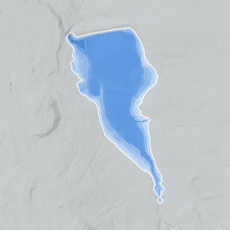
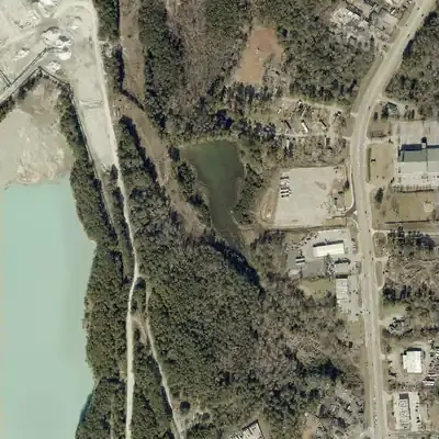
Today: Since 2021 the lake has stayed at about half its size, a brown to green pool of roughly 4 acres in the north, with bare and marshy ground where the old shoreline was.
- Area
- 7.3 acres
- Deepest
- about 13 ft
- Method
- Refilled from lidar
- Checked against
- 2017 aerial
The old lakebed is still in the ground. The water was put back in the county’s lidar up to the old shoreline, with any broken dam patched, and checked against the 2017 aerial photo. Full-pool level is uncertain by 1 to 2 feet. The cause of the low water, possibly a cut at the west end of the dam, is inferred. Depth is a model figure. How Watermarks work.
From the air
Charles Lake was built on a farm stream after 1940, drained completely in 1972, refilled, and since 2021 has held only about half its water, probably because of a cut at the dam's west end.
- First seen
- No lake in 1940; a lake behind a dam is there in 1955.
- Dam in the lidar
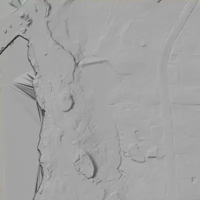
- An earth dam at the north end, about 22 to 25 feet high and roughly 370 to 400 feet long, with a flat crest near 920 feet elevation. At its west end a channel is cut down to about 905 feet, probably a spillway or a partial washout. The crest itself looks intact.
- Depth from the lidar
- The county's 2024 lidar survey caught the lake low. Water over today's pool is at least 5 to 6 feet deep. That is a minimum: the bed under the water is unknown, and the normal full-lake level is uncertain, between about 914 and 916 feet.
Low water and drawdowns
- 1972: The whole lake bed lay bare and pale, with a faint channel and a gullied south end. The dam looked intact. Full again by 1981.
- Between 2017 and 2021, still low in 2026: The pool shrank to about half the lake outline, roughly 4 acres, and wetland plants took over the exposed edges. The cause is probably a cut at the dam's west end.
- 1955 (uncertain) possibly: The water was narrower than in 1968, with bare rims. It may be a newly built lake still filling, or a low pool. The old photos cannot tell which.
Read from aerial photos taken between 1940 and 2026 and from DeKalb County 2024 lidar, then checked by a second reading. How the photos were read.
History
The National Inventory of Dams lists Charles Lake Dam (other name Davidson Lake Dam 2): a 22-ft earth dam about 400 ft long, owned by Davidson Mineral Properties, with 7.5 surface acres, 45 acre-feet of normal storage, a low hazard rating and no condition rating. NID gives 1949 for completion and water supply as the use; the stream is 'Unknown'. USGS map data name the water body at this point Davidson Lake One, with a second reservoir, Davidson Lake Two, about 350 m north. Georgia does not treat the dam as state-jurisdictional. No builder, history, news coverage or public access was found. 123
Who built it
Not established. NID gives 1949 and 'Water Supply', and lists the designer as the owner, Davidson Mineral Properties; these fields for small private dams are often estimates. The Davidson name on USGS maps points to the Davidson family of Arabia Mountain-area quarry owners described on Wikipedia, but no source ties this company or this pond to that family, so treat the link as an unconfirmed lead. Why NID says 'Charles' is unknown. 134
Timeline
- 1949Year of completion given in the National Inventory of Dams. Treat as an estimate: NID does not say who built the dam or how the year was determined, and lists the designer as the owner company. Uncertain 1
- May 1, 2005Last inspection date recorded in the NID for this dam. The same date appears on other Georgia records from the same NID data set, so it may be a batch entry. 1
- 2016-2017Area becomes the city of Stonecrest: voters approved incorporation in November 2016 and the first city officials were elected in March 2017, per Wikipedia (single source). Likely 5
Names
- Davidson Lake Dam 2
- Alternate name listed in the National Inventory of Dams record for this dam. 1
The dam
Per NID (record updated 04/20/2021): earth dam, 22 ft high (15 ft hydraulic height), about 400 ft long; uncontrolled spillway and outlet; normal storage 45 acre-ft, maximum 69 acre-ft; 7.5 surface acres; low hazard; condition 'Not Rated'; state ID 044-059-00798; not state-regulated or state-jurisdictional; last inspection date 05/01/2005; no emergency action plan required. Year completed 1949 is unverified. Stream is 'Unknown'. No rebuild or drawdown records found. 1
- Year in the inventory
- 1949
- Dam height
- 22 ft
- Surface
- 7.5 acres
- Average depth
- about 6 ft
- Owner type
- Private
Figures from the U.S. Army Corps of Engineers’ National Inventory of Dams. Its “year” is often a rebuild or survey date, and average depth is storage divided by area.
Visiting
Getting there
Listed as privately owned by a company (Davidson Mineral Properties) in the NID. No public access, park or marker was found. The water body lies about 285 m west of Rock Chapel Road; whether it is visible from public right-of-way was not confirmed. Do not assume a visitor may enter the property.
What you can see
Not confirmed. Check current aerial imagery to see whether the water and dam are visible from Rock Chapel Road or another public road. The USGS map data show two adjacent mapped reservoirs (Davidson Lake One and Two).
Look, don’t dig. Parks, cemeteries and preserves are off limits to digging and collecting, and private land needs the owner’s permission to enter.
Open questions
- Who built the dam, and was it in 1949 or another year?
- Which stream or drainage does it impound? NID says 'Unknown' and lists drainage area as 0.
- Why does NID call it 'Charles Lake' when USGS names the water 'Davidson Lake One'? Is 'Charles' an owner, family or property name?
- Is Davidson Mineral Properties connected to the Davidson family of Arabia Mountain-area quarry owners, and was the pond tied to quarry or grit operations?
- Which lake does the NID label 'Davidson Lake Dam 2' describe, given Lake One contains the NID point and Lake Two is about 350 m north?
- Was the 'water supply' use real, or a default code?
- Is the lake still full, and has the dam changed since the 2005 inspection date?
Know something? Write to hello@historyunderfoot.org. Family papers, photos and deeds often settle these.
Where to look next
- UGA 1938-40 DeKalb County aerial photographs, to see whether a pond exists at the coordinates before 1949 (UGA Libraries Map and Government Information Library, historic aerials)
- USGS 7.5-minute topographic quadrangle editions for the Lithonia area (1950s-1970s), to date the first appearance of the pond and the 'Davidson Lake' names (USGS Historical Topographic Map Collection (topoView))
- DeKalb County deed and plat records for the parcel, to trace Davidson Mineral Properties and any 'Charles' connection (DeKalb County Superior Court Clerk, real estate records and plat books)
- Georgia EPD Safe Dams Program, to ask whether any file exists for state ID 044-059-00798 (NID shows the dam as not state-regulated) (Georgia Environmental Protection Division, Safe Dams Program)
- Search for 'Davidson Lake', 'Davidson Mineral Properties' and 'Rock Chapel' with Lithonia, 1940s onward (Digital Library of Georgia, Georgia Historic Newspapers)
- Local history on the Davidson family quarries and grit business and on the Rock Chapel community (DeKalb History Center archives; Arabia Mountain Heritage Area Alliance)
Sources
- National Inventory of Dams national CSV download, record GA01789 (Charles Lake Dam; other name Davidson Lake Dam 2), data last updated 2026-09-23, record updated 04/20/2021 U.S. Army Corps of Engineers, National Inventory of Dams
- USGS National Hydrography Dataset waterbody layer, point query at 33.72822, -84.09658 (returns Davidson Lake One, GNIS 00337914, 0.027 sq km) U.S. Geological Survey, National Map
- USGS Geographic Names (GNIS) hydrography layer: Davidson Lake One (337914), Davidson Lake Two (338648), Davidson Lakes (325915), DeKalb County U.S. Geological Survey, National Map
- Davidson-Arabia Mountain Nature Preserve Wikipedia
- Stonecrest, Georgia Wikipedia