Still here · DeKalb County · Dam inventory GA03930
Dunwoody Club Crossing Lake
A 2-acre lake in a Dunwoody residential area whose dam is high-hazard, rated Poor in a June 2026 NID update, and shared among several owners including an HOA.
From the air
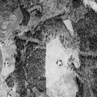
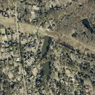
Dunwoody Club Crossing Lake did not exist in 1981. It appears in the 1993 aerial, and its outline has not changed since.
- First seen
- First seen in the 1993 aerial; the site was still woods in 1981.
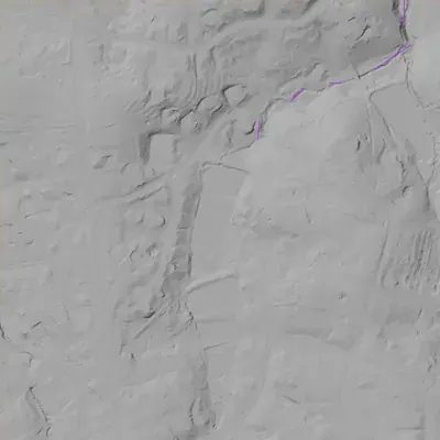
- Dam in the lidar
- An earth dam closes the north end, about 275 to 285 feet long. The crest is level at about 1,037 feet, roughly 3.5 feet above the lake. It is about 15 feet high at the spillway and 26 to 27 feet at the east end. No breach is visible.
Read from aerial photos taken between 1940 and 2026 and from DeKalb County 2024 lidar, then checked by a second reading. How the photos were read.
Depth
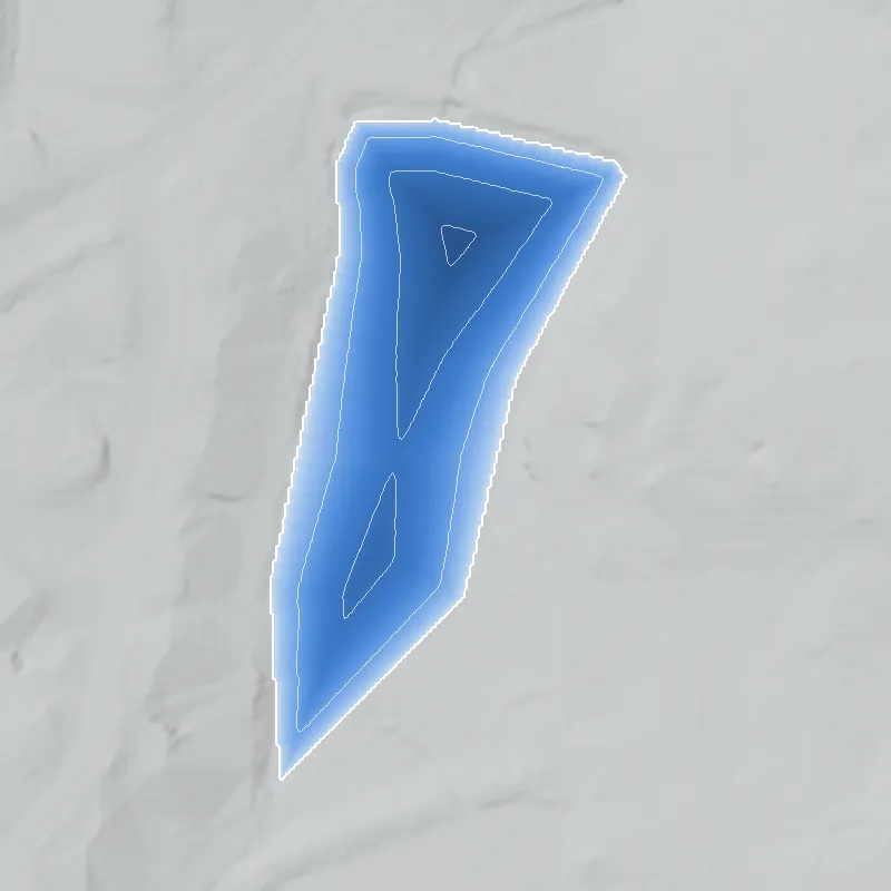
Modeled from the shoreline shape and the dam inventory’s average depth: deepest point about 16 ft. Treat it as an estimate; no survey of the lake bottom was found. How depth is estimated.
History
Dunwoody Club Crossing Lake is a 2-acre recreation lake with a 33-foot earth dam in the Mount Vernon Lake area of Dunwoody. It is the most documented dam in this bundle, mainly because it is the only one Georgia classes as Category I (failure would probably cause loss of life). The National Inventory of Dams lists a High hazard class, a Poor condition rating dated June 30, 2026, a February 2025 inspection, a 2-year inspection cycle, and no emergency action plan prepared. The dam is state-regulated and its listed owners include a homeowners' association and private parties. NID gives 1988 as the completion year. 1234
Who built it
NID lists 1988 as the completion year, an unknown designer, and recreation as the purpose. Per Wikipedia, Dunwoody stayed rural until suburban development began in the 1960s and grew rapidly after Perimeter Mall (1971), which fits a late-1980s residential lake. No plat, builder or permit was found, and 1988 may be an estimate. NHDPlus places the lake on a small unnamed stream that runs north toward the Chattahoochee. 156
Timeline
- 1988Completion year given in the National Inventory of Dams. NID completion years are often estimates, so this is unconfirmed. Uncertain 1
- December 1, 2008Dunwoody becomes a city, per Wikipedia. The lake's 1988 completion date, if right, predates cityhood, when the area was unincorporated DeKalb County. Likely 6
- February 20, 2025Most recent dam-safety inspection date recorded in NID, on a 2-year inspection cycle. 1
- June 4, 2025Georgia EPD's dam inventory lists the dam as Category I, the only one of the four bundle dams in that class. 23
- June 30, 2026NID record updated: condition assessed as Poor, hazard High, with the emergency action plan listed as not prepared. 1
Names
The dam
Earth dam, 33 ft high (33.2 ft in the state inventory; 18 ft hydraulic height), 295 ft long, with 14 acre-ft normal and 23 acre-ft maximum storage over about 2 acres. Uncontrolled spillway and outlet. NID lists hazard potential High, condition Poor (assessed June 30, 2026), last inspection February 20, 2025 on a 2-year cycle, and 'EAP Prepared: No'. It is flagged as state regulated with permitting, inspection and enforcement authority. The other three lakes list EAPs as 'Not Required'. Georgia EPD lists it as Category I. Listed owners are a homeowners' association and private individuals; EPD notes owner names come from county tax records and may be out of date. No contracts, drawdowns or rebuild plans were found; I could not reach EPD's high-hazard page. 123
- Year in the inventory
- 1988
- Dam height
- 33 ft
- Surface
- 2 acres
- Average depth
- about 7 ft
- Owner type
- Private
Figures from the U.S. Army Corps of Engineers’ National Inventory of Dams. Its “year” is often a rebuild or survey date, and average depth is storage divided by area.
Around the lake
Water
NHDPlus tracing runs north from the lake along a small unnamed stream to the Chattahoochee River. USGS watershed data place it in the Crooked Creek-Chattahoochee River subwatershed (HUC-12 031300010907), Upper Chattahoochee basin, unlike the other three lakes, which drain to the Yellow River and Ocmulgee. GNIS lists Ball Mill Creek and March Creek within about 1 to 2.5 km, but the trace does not confirm which, if either, receives the lake's outflow. Treat the stream connection as likely.
Visiting
Getting there
Private. NID and the EPD inventory list private owners, including a homeowners' association. No public access is documented.
What you can see
Nothing documented for visitors. The lake sits in a residential area along Dunwoody Club Crossing, so a view from a public street is the most that could be possible. I could not confirm one.
Look, don’t dig. Parks, cemeteries and preserves are off limits to digging and collecting, and private land needs the owner’s permission to enter.
Open questions
- Has the Poor rating been followed by a repair order, engineering study, or contract? Nothing public was found.
- Was the lake built for the Dunwoody Club Crossing development or the older Mount Vernon Lake subdivision, and is 1988 accurate?
- Which stream does it impound? NID says 'Unknown'; the NHDPlus trace runs north on an unnamed stream.
- Why is an emergency action plan listed as not prepared for a High hazard dam, and has that changed?
- Are the HOA and the other owners jointly responsible for the dam, and how is its upkeep funded?
Know something? Write to hello@historyunderfoot.org. Family papers, photos and deeds often settle these.
Where to look next
- Georgia EPD Safe Dams file for state ID 044-104-04510 (permit, design, inspection reports, correspondence, EAP status); open records request (Georgia EPD Safe Dams Program)
- USGS Chamblee 7.5-minute quadrangles (1954, 1993) to date the lake's first appearance (USGS TopoView / The National Map historical topo collection)
- DeKalb County plat books for the Mount Vernon Lake and Dunwoody Club Crossing subdivisions (developer, dates, lake lot) (DeKalb County Clerk of Superior Court, Real Estate Division)
- City of Dunwoody council, stormwater or community development records mentioning the dam (City of Dunwoody)
- 1930s-40s aerial photographs of DeKalb County for pre-1960s land use near the lake (availability for DeKalb not verified; check UGA Libraries Map and Government Information and USGS EarthExplorer) (University of Georgia Libraries / USGS EarthExplorer)
Sources
- National Inventory of Dams: records GA03912, GA03926, GA03929, GA03930 (national CSV download, data updated 2026-09-23) U.S. Army Corps of Engineers
- Georgia Dam Inventory, updated June 4, 2025 (Excel) Georgia EPD, Safe Dams Program
- Safe Dams Program (Category I/II definitions, regulation thresholds) Georgia EPD
- OpenStreetMap Nominatim geocoder (reverse and place search, incl. Stone Mountain Park outline) OpenStreetMap contributors
- Network Linked Data Index (NHDPlus downstream navigation) USGS
- Dunwoody, Georgia Wikipedia
- Geographic Names Information System (geonames MapServer) USGS