Still here · Fulton County · Dam inventory GA01899
East Point Reservoir
A 41-foot earth dam on a roughly 17-acre water-supply reservoir in southwest Atlanta; federal data lists a local-government owner and a 1965 completion year.
From the air
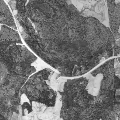
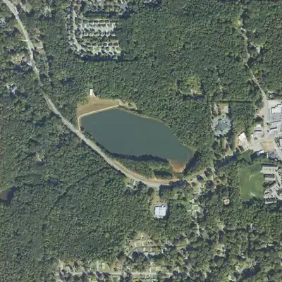
East Point Reservoir was built between 1940 and 1955, not 1965 as the record says. Its lake and 39-to-51-foot earth dam are already in the 1955 aerial, and the lake's shape has not changed since.
- First seen
- The lake and dam are already in the 1955 aerial; the site is woods in 1940, so it was built between those years.
- Dam in the lidar
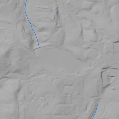
- A broad earth dam at the north-northwest end, about 590 feet long. The crest is level at about 933 feet, roughly 7 feet above the lake. Downstream drop is about 39 feet mid-dam and up to about 51 feet at the west end, over a side ravine. No breach. The spillway was not found; it is probably a pipe or drop inlet.
Read from aerial photos taken between 1940 and 2026 and from USGS 3DEP lidar, then checked by a second reading. How the photos were read.
Depth
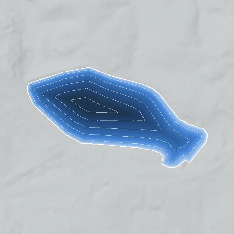
Modeled from the shoreline shape and the dam inventory’s average depth: deepest point about 28 ft. Treat it as an estimate; no survey of the lake bottom was found. How depth is estimated.
History
The National Inventory of Dams lists East Point Reservoir Dam as a 41-foot, 550-foot-long earth dam with about 17 surface acres and 212 acre-feet of normal storage. It is rated High hazard, Fair condition, and is regulated by Georgia's Safe Dams Program. The designer is listed as Wiedeman & Singleton. NID gives 1965 as completion, a year that is often an estimate. No document on the builder, purpose or history was retrieved in this pass, so the record here is thin. 1
Who built it
NID names the designer as Wiedeman & Singleton, gives the primary purpose as Water Supply, lists a local-government owner, and dates completion to 1965. The owner is probably the City of East Point, based on the dam's name and the NHD label 'City of East Point Reservoir', but no document confirming this was retrieved. NID lists the stream as 'Unknown'. No named NHD flowline lies within about 3 km; the nearest named streams are Camp Creek (about 3.0 km), Wolf Creek (about 3.1 km) and Wilson Creek (about 3.7 km). The reservoir most likely impounds an unnamed tributary in the Camp Creek area; this is an inference. 12
Timeline
- 1965NID lists this as the year the dam was completed. Designer given as Wiedeman & Singleton. The year is unverified and could be a permit or design date. Uncertain 1
- January 19, 2017Last state inspection date shown in the NID record; the record lists a 2-year inspection frequency. 1
- August 11, 2026NID data-update and condition-assessment date. The dam is listed with High hazard potential and Fair condition. 1
Names
- East Point Reservoir Dam
- Official dam name in the National Inventory of Dams (NID) record GA01899. 1
- East Point Ben Hill
- Alternate name in NID. NID also uses 'Ben Hill' as the place label for several nearby lake dams (Cowart, Vandivers, Niskey and Princeton lakes), so it is likely a locality tag for the Ben Hill area of southwest Atlanta. That reading is an inference; the record does not explain it. 1
- Dam No. 1
- Alternate name in NID. It suggests another dam in the same scheme, but no 'Dam No. 2' appears in NID under East Point or Ben Hill names. 1
- City of East Point Reservoir
- Name on this waterbody in the USGS National Hydrography Dataset (NHD). 2
The dam
Earth dam, 41 ft NID height (27 ft hydraulic and structural height), 550 ft long, 236 acre-ft maximum and 212 acre-ft normal storage, 17 surface acres. NID's drainage-area entry is 50 (NID reports square miles), which is implausible for a 17-acre pond and is probably a data-entry error. Spillway and outlet are both listed as uncontrolled. State ID 060-097-01292. Hazard: High. Condition: Fair. Last state inspection listed: January 19, 2017, with a 2-year inspection frequency. NID lists no modification years and no emergency action plan information. No rebuild, repair contract or Legistar record was found. 1
- Year in the inventory
- 1965
- Dam height
- 41 ft
- Surface
- 17 acres
- Average depth
- about 12.5 ft
- Owner type
- Local Government
Figures from the U.S. Army Corps of Engineers’ National Inventory of Dams. Its “year” is often a rebuild or survey date, and average depth is storage divided by area.
Around the lake
Water
The reservoir sits in the HUC-12 watershed USGS labels 'Utoy Creek' (031300020103, Chattahoochee basin). The nearest named streams, Camp Creek and Wolf Creek, are about 3 km away in NHD. The reservoir's own feeder stream is unnamed in NHD.
Visiting
Getting there
Access not confirmed. Federal records list a local-government owner and water-supply use, and no public park or access point was found in the records checked. Do not assume it is open; check with the owner before visiting.
What you can see
Not confirmed. NID describes an earth embankment with an uncontrolled spillway. Whether any of it can be seen from public roads has not been checked.
Look, don’t dig. Parks, cemeteries and preserves are off limits to digging and collecting, and private land needs the owner’s permission to enter.
Open questions
- Who built the reservoir, and when? NID's 1965 date is unverified.
- Which unnamed tributary does it dam, and was it built to supply East Point's water system?
- Is there a 'Dam No. 2', and does 'Ben Hill' in the alternate name simply mark the locality?
- If East Point owns it, as the NHD label suggests, how did an East Point reservoir come to lie in Atlanta, and did any annexation or land deal affect it?
- Has the dam been repaired or modified since 1965? NID lists none, and the state's last listed inspection is from 2017.
- Is the reservoir still in service as a water source, or is it now a reserve or stormwater pond?
Know something? Write to hello@historyunderfoot.org. Family papers, photos and deeds often settle these.
Where to look next
- Georgia EPD Safe Dams Program file for dam ID 060-097-01292, including permit, plans, inspection reports and any repair orders (open-records request). (Georgia Environmental Protection Division, Safe Dams Program)
- City of East Point council minutes, water-supply bond referendum records, and capital project files for a 1960s reservoir. (City of East Point city clerk and Fulton County records)
- Wiedeman & Singleton, consulting engineers: project reports and plans for the East Point water system. (Georgia Tech Archives or Atlanta History Center (holdings not verified))
- Historic USGS topographic maps for the quadrangle covering this point, comparing pre-1965 and post-1965 editions to date the impoundment. (USGS TopoView)
- Historic aerial photographs of southwest Fulton County, 1950s to 1970s, to see the valley before and after the dam. (UGA Map and Government Information Library; Fulton County GIS)
- Georgia Historic Newspapers and Atlanta Constitution/Journal searches for 'East Point reservoir', 'East Point water supply' and 'Camp Creek reservoir', 1955-1970. (Digital Library of Georgia)