Still here · DeKalb County · Dam inventory GA01324
Erin Lake
A 12-acre recreation lake in Tucker held by a 34-foot earth dam that state inspectors rated Poor in 2019; OpenStreetMap maps a city rebuild project.
Watermark
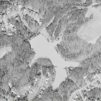
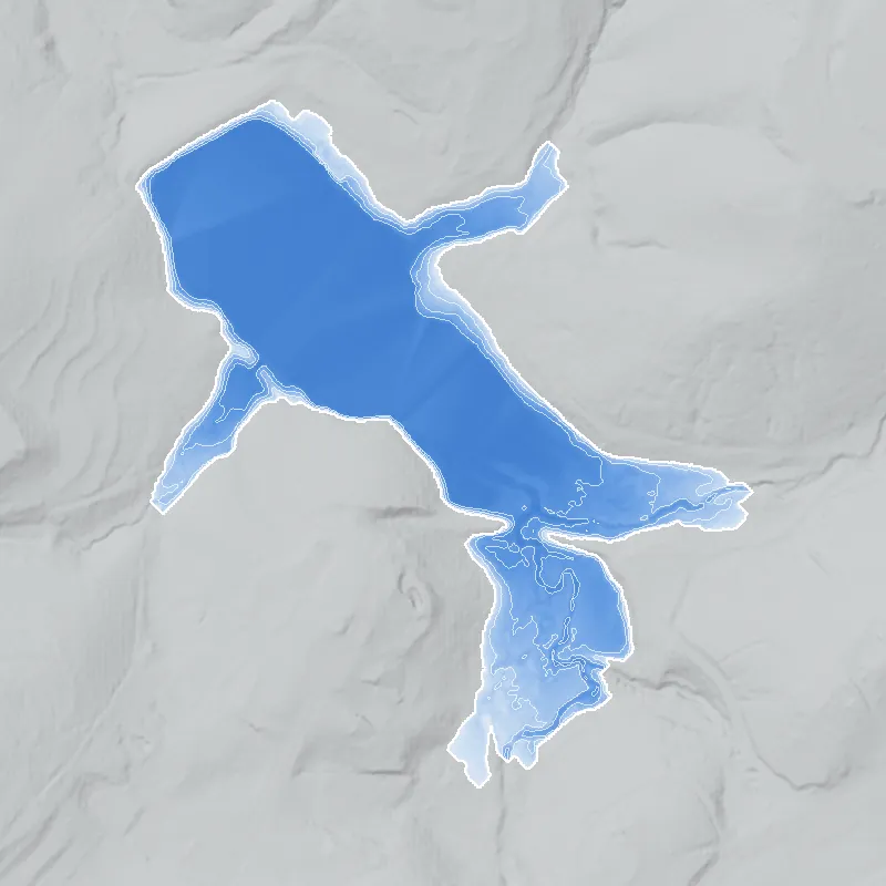
Erin Lake, twice as big in 1972
In 1972 Erin Lake filled about 11.5 acres, roughly twice today's size, with long arms reaching south and east. It was around 8 feet deep at its deepest, held back by the earth dam at its north-west end.
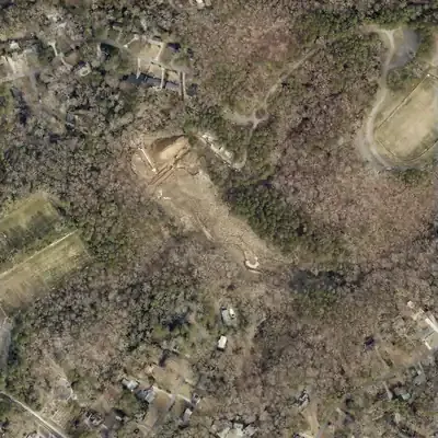
Today: Since about 1981 the lake has held only about 5.6 acres near the dam. The old south and east arms are now wetland and woods. In 2026 the lake was drained for dam work.
- Area
- 11.2 acres
- Deepest
- about 8 ft
- Method
- Refilled from lidar
- Checked against
- 1972 aerial
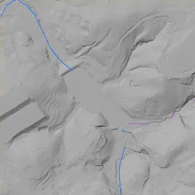
The old lakebed is still in the ground. The water was put back in the county’s lidar up to the old shoreline, with any broken dam patched, and checked against the 1972 aerial photo. The old water level (about 964 ft) is estimated by matching the 1972 photo to terrain shapes. Old photos are slightly shifted, and why the lake dropped is not visible. How Watermarks work.
From the air
In the late 1960s and early 1970s Erin Lake was about twice its present size. By 1981 the water had dropped roughly 6-7 feet, and in 2026 the lake was drained for dam work.
- First seen
- The 1955 aerial already shows the dam and a partly filled pool, with bare ground that suggests the dam was newly built.
- Dam in the lidar
- An earth dam at the northwest end of the lake, about 31 feet high from the downstream toe and about 327 feet long. The crest is flat at about 969 feet, roughly 13 feet above the pool. No breach shows. The spillway location is unclear from the images.
Low water and drawdowns
- Between the 2025 and 2026 county aerials (early 2025 to early 2026; exact date unknown): The 2025 photo shows a full pool. The 2026 photo shows the whole lakebed exposed, with a stream channel, an excavation and trenches at the dam, and a white pipe across it. This is a full drain for dam reconstruction.
- About 1955: The dam looks freshly built and the south and southeast arms are bare. This is probably a new lake still filling, though a low water level cannot be ruled out.
Read from aerial photos taken between 1940 and 2026 and from DeKalb County 2024 lidar, then checked by a second reading. How the photos were read.
History
Erin Lake, usually called Lake Erin, is a 12-acre impoundment in Tucker, near Henderson Park Road and the Lake Erin street names. The National Inventory of Dams lists a 34-foot, 366-foot-long earth dam with an uncontrolled spillway, a High hazard rating, and a Poor condition rating from a March 2019 Georgia Safe Dams inspection. NID dates it to 1960, which is unverified. OpenStreetMap maps a 'Lake Erin Dam reconstruction project' operated by the City of Tucker with a 2026 opening tag, but no city record was reached to confirm it. Builder, original purpose and early history are not documented in the sources reached. 123
Who built it
Not established. NID gives 1960 as year completed, designer 'UNKNOWN', primary purpose Recreation, and an earth dam. Both the date and the purpose may be estimates. The builder, the impounded stream and the original owner could not be confirmed from any source reached. NID names the Chattahoochee River, which is the receiving river basin rather than a local stream. 1
Timeline
- 1960 (per NID, unverified)National Inventory of Dams gives 1960 as the year the Erin Lake dam was completed. NID dates are often estimates, and no construction record was found to confirm it. Uncertain 1
- March 28, 2019Last Georgia Safe Dams inspection and condition assessment recorded in NID; dam rated Poor condition with High hazard potential. 1
- April 20, 2021Date the NID record for this dam was last updated (data-updated field). 1
- 2026 (OSM tag; unconfirmed)OpenStreetMap maps a 'Lake Erin Dam reconstruction project' operated by the City of Tucker with an opening date of 2026. Crowd-sourced tags; no city record was reached, and completion is not confirmed. Uncertain 3
Names
- Lake Erin
- Name on OpenStreetMap's lake polygon and on the nearby streets Lake Erin Drive and Lake Erin Court in Tucker. This is the form the map and street names use; the NID reverses it. 2
- Erin Lake Dam
- Official NID name of the dam (record GA01324). 1
- Lake Erine Dam
- Spelling on the OpenStreetMap dam node, which is tagged with NID id GA01324. Probably a mapper's variant spelling, not a documented historic name. 3
The dam
NID: earth dam, 34 ft high, 366 ft long, 166 acre-feet maximum storage, 12-acre surface, uncontrolled spillway and outlet, no associated structures, drainage area recorded as 0 (blank). Owner type Local Government. State-regulated by the Georgia Safe Dams Program (state ID 044-004-00033), inspection frequency every 2 years. Last inspection and condition assessment 28 March 2019: hazard High, condition Poor. OpenStreetMap tags the dam node at 298 m elevation and the lake at 289 m (OSM elevations are in meters, so roughly a 9 m, or about 30 ft, drop, consistent with NID's 34 ft height), and maps a 'Lake Erin Dam reconstruction project' operated by the City of Tucker with an opening date of 2026. No contract number, engineer or bid record was found. 13
- Year in the inventory
- 1960
- Dam height
- 34 ft
- Surface
- 12 acres
- Stream
- Chattahoochee River
- Owner type
- Local Government
Figures from the U.S. Army Corps of Engineers’ National Inventory of Dams. Its “year” is often a rebuild or survey date, and average depth is storage divided by area.
Around the lake
Water
NID names the Chattahoochee River as the stream, which is the wider basin. The actual tributary and drainage area are not confirmed; NID's drainage area is blank (0).
Civil War
Two Georgia Historical Commission-era markers give context nearby. 'Logan's 15th Corps & Garrard's Cavalry' (erected 1954, on Chamblee Tucker Road, about 1.8 km northeast of the lake) says Logan's 15th Corps moved to Browning's (Tucker) on July 18, 1864 in support of Garrard's cavalry. 'Site: Henderson's Mill' (about 2.2 km west-southwest) says the corps withdrew there for lack of water at Browning's and camped the night of July 18, 1864. Neither marker places troops at the lake itself.
Before 1861
The HMDB 'Site: Henderson's Mill' marker records a grist mill, about 2.2 km west-southwest of the lake, owned and operated before and after the Civil War by Greenville Henderson (1792-1869) and his son Rufus (1823-1872); the marker says it was demolished in 1911. That shows mills and roads in the area long before the lake, but no source ties the lake site to a specific pre-1860 land lot, mill or road.
Visiting
Getting there
Not confirmed. NID lists the owner only as 'Local Government' and the primary purpose as Recreation. OpenStreetMap names the City of Tucker as operator of the dam reconstruction project. Whether the lake is currently open to the public, drained or fenced during construction was not confirmed as of 2026, and no public access point was verified.
What you can see
Unverified. A lake of about 12 acres with an earthen dam at its west end, and possibly construction work if the mapped reconstruction is under way. Check City of Tucker notices before visiting.
Look, don’t dig. Parks, cemeteries and preserves are off limits to digging and collecting, and private land needs the owner’s permission to enter.
Open questions
- Who built the dam and lake, and when? NID says 1960, designer unknown.
- Was it a private subdivision or club lake before a public body took it over? When did the county or City of Tucker acquire it?
- Which stream does it impound, and how big is its drainage area (blank in NID)?
- What contract, engineer and schedule cover the Lake Erin Dam reconstruction, and is it complete?
- Is the name Erin or Erine on early plats and topo maps?
Know something? Write to hello@historyunderfoot.org. Family papers, photos and deeds often settle these.
Where to look next
- Georgia Safe Dams Program file for dam ID 044-004-00033: inspection reports, permits, any repair orders and rebuild plans (open records request to Georgia EPD). (Georgia EPD Safe Dams Program (link given in the NID record))
- City of Tucker council agendas, bid notices and capital project pages for the Lake Erin dam reconstruction, including contract number and engineer. (City of Tucker government)
- DeKalb County plat records and deeds for the Lake Erin subdivision and the surrounding land, to establish who built the lake and when. (DeKalb County Superior Court Clerk, real estate records)
- UGA 1938-40 DeKalb aerials and USGS Tucker/Stone Mountain quadrangle editions (1950s to 1970s) to see whether the lake exists before or after 1960. (UGA Map and Government Information Library; USGS historical topo collection)
- HMDB marker 'Site: Henderson's Mill' (July 1864 camp, mill of Greenville and Rufus Henderson), about 2.2 km west-southwest, for local context. (Historical Marker Database)
- Georgia Historic Newspapers (Digital Library of Georgia) for Tucker or DeKalb news on Lake Erin, 1960s to present. (Digital Library of Georgia)
Sources
- National Inventory of Dams record GA01324, Erin Lake Dam (queried via USACE NID FeatureServer) U.S. Army Corps of Engineers
- OpenStreetMap Nominatim geocoding results: Lake Erin, Lake Erin Drive, Lake Erin Court, Henderson Park Road, Tucker GA OpenStreetMap contributors
- OpenStreetMap lookup: Lake Erine Dam node (ref:US:NID GA01324), Lake Erin polygon and Lake Erin Dam reconstruction project way OpenStreetMap contributors