Still here · DeKalb County · Dam inventory GA01801
Howell Lake
A 10-acre lake behind a 22-foot earth dam in Stone Mountain Park, listed in federal dam records as owned by the Stone Mountain Memorial Association.
Watermark
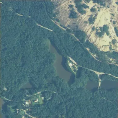
Howell Lake, full in 2005
Howell Lake was a long, narrow lake of about 9 acres behind a 300-foot earth dam, reaching roughly 5 feet deep in the measured basin. It looked like this in aerial photos from 1955 through 2005.
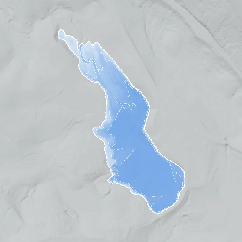
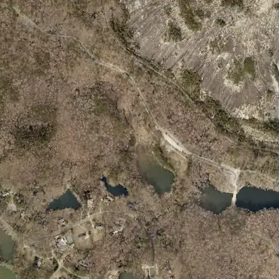
Today: Only the southern 4.5 acres still hold open water. The northern half is now a reed marsh with a small stream winding through it.
- Area
- 8.7 acres
- Deepest
- about 5 ft
- Method
- Refilled from lidar
- Checked against
- 2005 aerial
The old lakebed is still in the ground. The water was put back in the county’s lidar up to the old shoreline, with any broken dam patched, and checked against the 2005 aerial photo. The pool sat about 4 to 5 feet higher than today's water; why it dropped is unknown. Depth is a minimum, since the bed under today's pool is not measured. How Watermarks work.
From the air
Howell Lake was a 9-acre lake through 2005. By 2012 its north half was a reed marsh, and only about 4.5 acres of open water remain at the dam end.
- First seen
- The lake is already full in the 1955 aerial photo, ringed by unbroken forest.
- Dam in the lidar
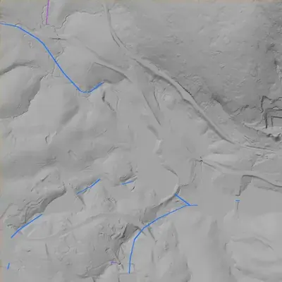
- Earth dam at the south-southeast end, about 300 feet long and 20 to 22 feet high. The crest is a continuous ridge with no breach or notch. It sits about 10 feet above today's water. A pale stepped stone or concrete face on the downstream side, seen in 2012, has an unclear purpose.
- Depth from the lidar
- The 2024 county lidar shows today's smaller pool as flat water, so it gives no depth there. The north half is now marsh ground; at the old water level, about 860 feet, it held at most about 5 feet of water.
Low water and drawdowns
- Between 1972 and 1981; refilled by 1993: In 1981 only the south end held water. The north half was a gray mud flat with a winding channel. Photos from 1972, 1993, 2001 and 2005 show it as open water, so this was a temporary low-water event. The cause is unknown.
- Between 2005 and 2012 (permanent): The north half stopped holding water and became a reed marsh with a winding stream. The water level appears to be about 4 to 5 feet lower than before. A new stone-faced structure shows on the dam's downstream side in 2012. A lowered outlet or dam work is the likely cause, but this is an inference.
Read from aerial photos taken between 1940 and 2026 and from DeKalb County 2024 lidar, then checked by a second reading. How the photos were read.
History
Howell Lake is a small earth-dam lake in the western part of Stone Mountain Park, DeKalb County. The National Inventory of Dams lists Howell Lake Dam (GA01801) as 22 feet high and 300 feet long, with about 10 surface acres, 80 acre-feet of normal storage and recreation as its use. The owner is the Stone Mountain Memorial Association, the state authority that has run the park since Georgia bought the mountain in 1958. The NID completion year is 1950, an unverified field. Hazard is Low and condition Not Rated. No builder, naming history or rebuild record was found. 123
Who built it
Not documented. The NID gives the designer as unknown, the stream as unknown and the use as recreation. Its 1950 completion year, if accurate, would predate the state's 1958 purchase of Stone Mountain, but that date is unverified. Nothing found says who Howell was or who built the dam. 13
Timeline
- 1950 (NID year completed)NID lists the dam as completed in 1950. NID completion years are often estimates, and no construction record, plat or newspaper mention was found to confirm it. Uncertain 1
- 1958Georgia buys Stone Mountain for about $2 million, and the Stone Mountain Memorial Association becomes the park authority. Whether this lake's land was in that purchase or added later is not documented. 3
- 1989 (NID last inspection date)NID lists a last inspection date of 01/01/1989 on a 5-year inspection cycle. The January 1 date suggests a placeholder rather than a real inspection. Uncertain 1
The dam
NID: earth dam, 22 ft high (21 ft hydraulic height), 300 ft long, about 10 surface acres, 80 acre-feet normal and 100 acre-feet maximum storage, uncontrolled spillway and outlet. Hazard potential Low, condition Not Rated, emergency action plan not required, state-jurisdictional. Georgia agency ID 044-081-01106. Last inspection is listed as 01/01/1989, which looks like a placeholder. The record was last updated 04/20/2021. Drainage area is listed as 0 sq mi, another placeholder. NID labels the owner type 'Private' even though the named owner is a state authority. No rebuild or drawdown record was found. 13
- Year in the inventory
- 1950
- Dam height
- 22 ft
- Surface
- 10 acres
- Average depth
- about 8 ft
- Owner type
- Private
Figures from the U.S. Army Corps of Engineers’ National Inventory of Dams. Its “year” is often a rebuild or survey date, and average depth is storage divided by area.
Around the lake
Water
NID lists the stream as Unknown and the drainage area as 0. The NHD reach code for the lake (03070103004178) places it in the Ocmulgee River basin, and NHD also maps a small pond named Catfish Pond about 350 m east at a lower elevation. Whether the two are connected is unverified.
Visiting
Getting there
NID and OpenStreetMap place the lake inside Stone Mountain Park, run by the Stone Mountain Memorial Association. Park entry for vehicles is charged per OSM tags, so confirm with the park. Whether the lake is open for fishing or boating is not documented. Stay on marked park trails.
What you can see
USGS National Map aerial imagery shows open water at the mapped spot, with a cleared area and gravel road beside it, woods around it, and the granite dome of Stone Mountain to the northeast. OpenStreetMap maps the Cherokee Trail (a walking path) passing at the dam's position. The dam's visible features are unconfirmed.
Look, don’t dig. Parks, cemeteries and preserves are off limits to digging and collecting, and private land needs the owner’s permission to enter.
Open questions
- Who built the dam, and was it in 1950 as the NID says or later, after the state acquired the land?
- Who was Howell: a landowner family whose farm became park land, or someone else?
- Which stream does it impound, and is it linked to the nearby Catfish Pond and Lanford Lake?
- Why does the NID list 'Lake Howell Dam' as an alternate name of the separate, privately owned O'Neal Lake Dam nearby?
- Has Georgia EPD Safe Dams inspected, repaired or reclassified this dam since 1989?
Know something? Write to hello@historyunderfoot.org. Family papers, photos and deeds often settle these.
Where to look next
- UGA 1938-40 DeKalb County aerial photographs. Check whether a pond exists near 33.799, -84.153 before 1950. (UGA Libraries Map and Government Information Library / Digital Library of Georgia)
- USGS topographic quadrangle editions (1950s-2020s) covering the site. Look for the first appearance of the lake and any name label. (USGS topoView)
- Georgia EPD Safe Dams program file for GA01801 (state ID 044-081-01106): inspection reports and owner history. (Georgia EPD Watershed Protection Branch, Safe Dams Program)
- Stone Mountain Memorial Association land-acquisition records and park master plans, which may show when this tract was added and who held it before. (Georgia Archives / Stone Mountain Memorial Association)
- Newspaper mentions of Howell Lake near Stone Mountain, 1945-1975. A quick full-text search for 'Howell Lake' plus 'Stone Mountain' returned no matches, so try variants such as 'Lake Howell' and 'Howell's pond'. (Georgia Historic Newspapers, Digital Library of Georgia)
Sources
- National Inventory of Dams, national CSV export (data updated 2026-09-23), record GA01801 Howell Lake Dam U.S. Army Corps of Engineers, National Inventory of Dams
- OpenStreetMap objects: Howell Lake Dam (way 1275448662, ref:US:NID GA01801), Howell Lake (way 1039920484, GNIS 358272 / NHD), Cherokee Trail, Stone Mountain Park boundary (relation 1447405) OpenStreetMap contributors (NHD/GNIS import)
- Stone Mountain (New Georgia Encyclopedia) Georgia Humanities / University of Georgia Press