Partly filled · DeKalb County · Dam inventory GA01334
Hunt Valley Lake
A roughly 19-acre private lake near Shadow Rock Drive in Redan: absent from the 1956 topo, drawn on a map from 1968 aerial photos.
Watermark
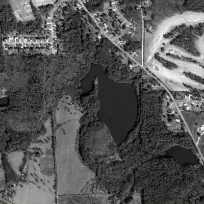
Hunt Valley Lake, full in 1981
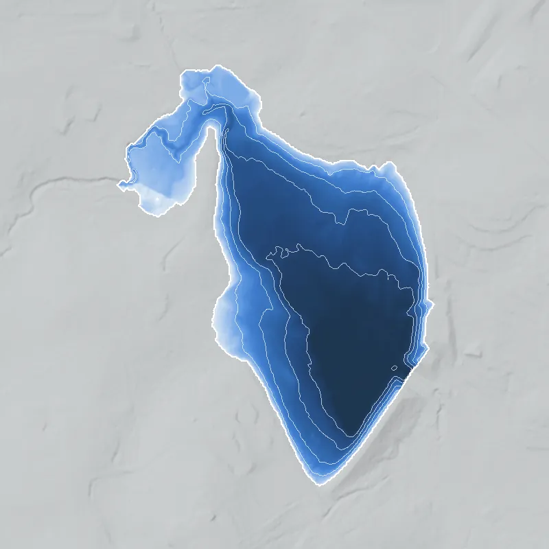
A private lake of about 19 acres, dammed in a small valley between 1955 and 1968. In 1981 it was full, dark and clean, roughly 26 feet deep at the dam, with a wooded peninsula dividing its west arm from the main basin.
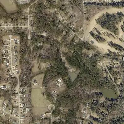
Today: The 38-foot earth dam still stands but has a wide gap in its northeast corner. Pines and shrubs cover the old lakebed, and only a pond of about one acre remains against the dam.
- Area
- 18.5 acres
- Deepest
- about 26 ft
- Method
- Refilled from lidar
- Checked against
- 1981 aerial
The old lakebed is still in the ground. The water was put back in the county’s lidar up to the old shoreline, with any broken dam patched, and checked against the 1981 aerial photo. The 912 ft pool level is estimated because the spillway is gone. The lake was dry in 1993, refilled by 2001, and drained again by 2012. Depths are minimums, since silt has raised the floor. How Watermarks work.
From the air
Hunt Valley Lake went from a dry, grassy lakebed in 1993 to full water by 2001, then drained again by 2012. Its dam still stands about 38 feet high, with a breach in one corner.
- First seen
- The valley was open pasture with no lake in 1955, and the lake appears in the 1968 aerial.
- Gone
- By 2012 the lake was gone, leaving a pond of about one acre against the dam.
- Dam in the lidar
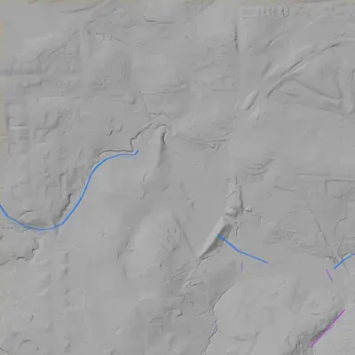
- An earth dam on the southeast and east sides, about 38 feet high, with a crest near 917 feet elevation. The southeast stretch is roughly 430 to 460 feet long and the east stretch about 300 feet. A breach about 200 feet wide cuts the northeast corner, down to about 888 feet. No spillway survives.
- Depth from the lidar
- The county's 2024 lidar survey saw the bed bare, so it shows the empty lake floor. At an estimated normal water level of 910 to 912 feet, the lake was at least 24 to 26 feet deep. These are minimums, because silt has raised the floor. The normal level is an estimate, since the spillway is gone.
Low water and drawdowns
- Between 1981 and 1993 possibly: The 1993 aerial shows no water at all. The basin is a light-toned, grassy lakebed with a gullied channel down the middle. It had probably been dry for a growing season or more. The cause is not visible.
- Between 2005 and 2012: Water reached the dam in 2005. By 2012 only a pond of about one acre was left, and young pines already grew in the old bed. The draining probably happened some years before 2012.
- About 2001 and 2005 (uncertain) possibly: The pool looked smaller than in 1981 and the west and north edges were dry. Much of this is likely silt at the upstream end. A drawdown of a few feet is possible but not clear.
Read from aerial photos taken between 1940 and 2026 and from DeKalb County 2024 lidar, then checked by a second reading. How the photos were read.
History
Hunt Valley Lake is a private earth-dam recreation lake near Redan in DeKalb County, on the Stone Mountain quadrangle. The National Inventory of Dams lists it as completed in 1968, 39 feet high, 1,102 feet long, about 19 surface acres, owned by Hunt Valley, Inc. The federal names database calls it Rutland Lake One. The 1956 USGS map shows only a stream valley; a lake is drawn from aerial photos taken in 1968. Georgia EPD's dam inventory classes the dam Category II, meaning no occupied structure was identified in a failure zone. Who built it, why, and where the name Rutland comes from is not in the records reached. 123456
Who built it
Not documented in the sources reached. The NID gives purpose as Recreation, owner Hunt Valley, Inc. (private), designer unknown, and stream unknown. Map evidence brackets construction between the 1956 map (aerial photos 1955, field check 1956), which shows no lake at the site, and 1968 aerial photography, which shows a lake. The 1968 NID date is consistent with that but is not independently confirmed. 1237
Timeline
- 1956USGS Stone Mountain 7.5-minute map (aerial photos 1955, field check 1956) shows a small stream valley at the site with no lake. Old Stone Mountain Road runs nearby and several older ponds appear to the north and west. 27
- 1968Aerial photographs taken this year are used by USGS to revise the Stone Mountain quad. A lake outline appears in purple at the site, marked as compiled from photos and not field checked. 3
- 1968 (NID)National Inventory of Dams gives 1968 as the year completed. NID years are often estimates, but it matches the map evidence that a lake existed by the 1968 photos. Likely 13
- March 2, 1970USGS file copy of the photorevised Stone Mountain quad is stamped with this date. The lake is drawn in purple as a photo-compiled revision, not field checked. 3
- 1973-1974A later photorevision using aerial photos from 1968 and 1973 (ScienceBase dates the sheet to 1974) still draws the lake in purple, with no field check. 7
- 1992The 1992 USGS quad (ScienceBase dates its source data 1988-1992) shows the lake in blue with a small tributary system and downstream ponds. It carries no lake name label; the road beside it is labeled Shadow Rock Rd. 8
- September 1, 1992Rutland Lake One is entered in the federal names database for the Stone Mountain quad, edited Feb. 12, 2019. A Rutland Dam One entry with the same date appears in a 2021 extract of the database. 4
- April 20, 2021NID record last updated: private owner Hunt Valley, Inc., Low hazard, Not Rated, not state-regulated. 1
- June 4, 2025Georgia EPD's Inventory of Dams lists Hunt Valley Lake Dam as Category II, state ID 044-028-00468, 39 ft high, 238 acre-ft, owner Hunt Valley, Inc. (taken from county tax records). 56
Names
- Rutland Lake One
- Federal geographic name for the reservoir in the USGS names database (Stone Mountain quadrangle, entered Sept. 1, 1992). The lake is not labeled on the 1992 topo sheet, and the source of the name Rutland is not documented in the records reached. 84
- Rutland Dam One
- NID alternate name for the dam. A USGS names entry for the embankment appears in the 2021 names extract but not in the 2026 file, which no longer carries dam features. A second pair, Rutland Lake Two and Rutland Dam Two, sits about 1.1 km northwest; Rutland Dam Two is not in the NID. 14
The dam
NID: earthfill dam, 39 ft high, 1,102 ft long, 238 acre-ft storage, about 19 surface acres, uncontrolled spillway and outlet. Hazard potential Low, condition Not Rated, emergency action plan not required. Georgia is listed as source agency (state ID 044-028-00468), but the NID flags the dam as not state-regulated. Georgia EPD's June 2025 inventory lists it as Category II (no occupied structure identified in the failure zone); EPD's program page says a permit is required for Category I dams. Designer unknown. The NID drainage area of 255 sq mi cannot be right for a small tributary basin and probably reflects an entry or units error. NID record last updated April 20, 2021. No rebuild, repair, or contract records found. 156
- Year in the inventory
- 1968
- Dam height
- 39 ft
- Surface
- 19 acres
- Owner type
- Private
Figures from the U.S. Army Corps of Engineers’ National Inventory of Dams. Its “year” is often a rebuild or survey date, and average depth is storage divided by area.
Around the lake
Water
NID lists the stream as Unknown. The 1992 quad shows the lake on a small unnamed tributary system whose outflow runs southeast past a downstream pond. Crooked Creek is labeled on the sheet about 2 km to the north-northeast. Which named creek and river basin the outflow reaches is not confirmed.
Before 1861
The 1956 quad labels the adjacent road Old Stone Mountain Road, an older route toward Stone Mountain; the 1992 quad labels the same road Shadow Rock Rd. No mill, plantation, or pre-1860 land lot record was found tying to this lake. Land lot and district would need to be checked in DeKalb GIS.
Visiting
Getting there
Private per NID (owner of record is a corporation, Hunt Valley, Inc.). No public access, park designation, or club use was confirmed. Nearby public roads include Shadow Rock Drive and Hunt Valley Drive; a visitor should stay on public right-of-way and not enter private property.
What you can see
Only from public roads, and only if sight lines exist; not verified. On the 1970 and 1992 maps the outflow stream leaves the lake at its south end, matching the Rutland Dam One point. No markers, ruins, or public overlook are known.
Look, don’t dig. Parks, cemeteries and preserves are off limits to digging and collecting, and private land needs the owner’s permission to enter.
Open questions
- Who built the dam, in what year, and for what purpose (subdivision amenity, club, fishing, or private estate)?
- What is Hunt Valley, Inc., and what is its relation to Hunt Valley Drive and any Hunt Valley subdivision plat?
- Where does the name Rutland come from, and was it a landowner, family, or plat name?
- Is the 1968 NID date accurate, or was the lake built earlier or later within 1956-1968?
- Which named creek and watershed does the outflow reach; the NID leaves the stream unknown.
- Was the lake ever used for swimming, boating, or a club, and is it still held by the same entity?
- Are there any Georgia EPD Safe Dams files under ID 044-028-00468?
Know something? Write to hello@historyunderfoot.org. Family papers, photos and deeds often settle these.
Where to look next
- Historic USGS Stone Mountain quads: 1956 base map, 1956 photorevised 1968 (printed 1970), 1956 photorevised 1968 and 1973 (1974), and 1992 edition, for side-by-side comparison of the lake and dam (USGS TopoView / Historical Topographic Map Collection (National Map))
- 1968 aerial photography behind the purple revision, plus earlier frames showing the pre-lake valley (UGA 1938-40 DeKalb aerials) (USGS EarthExplorer aerial archive; UGA Libraries DeKalb aerials)
- Plat books and deed records for the Hunt Valley area and the lake parcel (DeKalb County Clerk of Superior Court, real estate and plat records)
- Corporate history of Hunt Valley, Inc. (incorporation date, status) (Georgia Secretary of State business search (public corporate records))
- Safe Dams file for state ID 044-028-00468 and any construction permit or inspection letters (Georgia EPD Safe Dams Program, open records request)
- Newspaper mentions of Rutland Lake or Hunt Valley Lake, 1955-1975, in DeKalb newspapers (Georgia Historic Newspapers (Digital Library of Georgia))
- Parcel, land lot and district, and zoning history for the lake and dam parcels (DeKalb County GIS and Planning and Development records)
Sources
- National Inventory of Dams, nationwide CSV (data updated 2026-9-23), record GA01334 Hunt Valley Lake Dam U.S. Army Corps of Engineers, National Inventory of Dams
- USGS 1:24000-scale Quadrangle for Stone Mountain, GA, 1956 (ScienceBase dates 1955-57; map margin: aerial photos 1955, field check 1956), Historical Topographic Map U.S. Geological Survey
- USGS Stone Mountain, GA 7.5-minute quad, 1956, photorevised 1968 (stamped March 2, 1970) U.S. Geological Survey
- Geographic Names Information System, Georgia domestic names (Rutland Lake One 337924 and Rutland Lake Two 338663 in the Aug. 2026 file; Rutland Dam One 337923 and Rutland Dam Two 338662 in the 2021 extract) U.S. Board on Geographic Names / USGS
- Inventory of Dams (updated June 4, 2025), Georgia Safe Dams Program spreadsheet Georgia Environmental Protection Division
- Safe Dams Program (Category I and Category II definitions, permit requirement) Georgia Environmental Protection Division
- USGS Stone Mountain, GA 7.5-minute quad, 1956, photorevised 1968 and 1973 (ScienceBase dates 1956-1974) U.S. Geological Survey
- USGS 1:24000-scale Quadrangle for Stone Mountain, GA, 1992 U.S. Geological Survey
- OpenStreetMap Nominatim geocoder results for Rutland Lake One, Hunt Valley Drive, Shadow Rock Drive (Redan, DeKalb County) OpenStreetMap contributors