Dam breached · DeKalb County · Dam inventory GA01794
Jabco Lake
A private 9-acre recreation lake in southeast DeKalb with a 17-foot earthen dam, also listed as George Lake Dam; little else is documented.
Watermark
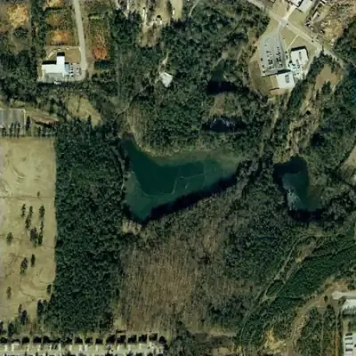
Jabco Lake, full in 2001
A private lake of about 9 acres, dammed before 1955 and held full through at least 2001. Average depth was around 6 feet, with the deepest water about 11 to 12 feet near the dam.
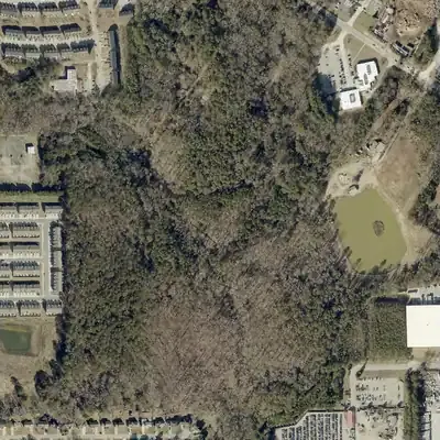
Today: The lake was drained between 2001 and 2005 through a cut in the dam. Today the old bed is forest and brush, with a small stream channel, surrounded by townhomes and warehouses.
- Area
- 8.6 acres
- Deepest
- about 14 ft
- Method
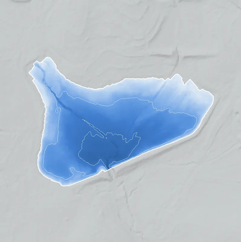
- Refilled from lidar
- Checked against
- 2001 aerial
The old lakebed is still in the ground. The water was put back in the county’s lidar up to the old shoreline, with any broken dam patched, and checked against the 2001 aerial photo. The 900 ft water level is estimated because the spillway is breached. Depth is approximate, since silt and erosion have changed the bed. The exact drain year is unknown. How Watermarks work.
From the air
Jabco Lake was a full 9-acre lake through 2001, then was drained by 2005. A cut through its dam let the water out, and the lakebed has been forest ever since.
- First seen
- Already a full lake in the 1955 aerial, so it was built before then. The 1940 photo does not cover it.
- Gone
- Drained sometime between the 2001 and 2005 aerials, and it has not refilled through 2026.
- Dam in the lidar
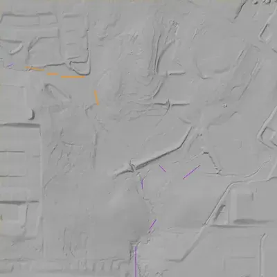
- A straight earth dam along the southeast edge, about 17 feet high and roughly 725 feet long, with a crest near 904 feet elevation. A V-shaped breach about 15 feet below the crest, where the old stream crosses, is still open. The county's 2024 lidar survey shows it.
- Depth from the lidar
- The 2024 lidar saw the dry lakebed, not water. The bed lies about 889 to 900 feet in elevation. Assuming a normal water level near 900 feet, the original deepest point was roughly 11 to 12 feet. These figures are approximate because of silt and the channel cut since.
Low water and drawdowns
- Between 2001 and 2005: The 2001 aerial shows a lake full of water. The 2005 aerial shows an empty bed of mud, grass and sand with a narrow channel and no open water. The lake was drained for good. The exact year is unknown.
Read from aerial photos taken between 1940 and 2026 and from DeKalb County 2024 lidar, then checked by a second reading. How the photos were read.
History
Jabco Lake is a private recreation lake in DeKalb County. The federal National Inventory of Dams lists an earthen dam 17 feet high and 920 feet long, holding about 51 acre-feet at normal pool over roughly 9 surface acres. The listed completion year is 1950, but the record names no builder, designer or impounded stream. The NID shows it as not state-regulated, rated Low hazard and Not Rated for condition. It also carries the alternate name George Lake Dam. No plat, newspaper or county record could be checked, so the lake's story remains open. 1
Who built it
Not documented in the sources reached. The NID lists the dam as earthen, built for recreation, completed 1950 (a year that is often an estimate), designer 'UNKNOWN', impounded stream 'Unknown'. Who built it and why is unresolved. 1
Timeline
Names
The dam
Earth embankment, 17 ft high (13 ft hydraulic height), 920 ft long; 9 surface acres, 51 acre-ft normal and 70 acre-ft maximum storage; uncontrolled spillway and outlet; Low hazard; condition Not Rated; NID record last updated April 2021. The NID shows no modification years, inspection dates or emergency action plan. Its state-regulated, state-jurisdiction, permitting, inspection and enforcement fields are all 'No'. No rebuilds or contracts were found. 1
- Year in the inventory
- 1950
- Dam height
- 17 ft
- Surface
- 9 acres
- Average depth
- about 5.7 ft
- Owner type
- Private
Figures from the U.S. Army Corps of Engineers’ National Inventory of Dams. Its “year” is often a rebuild or survey date, and average depth is storage divided by area.
Around the lake
Water
NID gives the stream as 'Unknown' and the drainage area as 0, so no watershed link is sourced.
Visiting
Getting there
Listed as privately owned in the NID (record updated April 2021). No public access or park designation was found, and the record does not say whether the owner is a club, an individual or an association. Current condition has not been checked against recent imagery.
What you can see
Nothing confirmed. Any view would be from public roads only, and no road with a view of the dam was confirmed.
Look, don’t dig. Parks, cemeteries and preserves are off limits to digging and collecting, and private land needs the owner’s permission to enter.
Open questions
- Who built the dam and impounded the lake, and what does 'Jabco' stand for (a person, company or club)?
- Who or what was 'George Lake' named for, and which name came first?
- Is the 1950 date real? Georgia Historic Newspapers and the 1949 GSU and 1938-40 UGA aerials could confirm whether a lake existed then.
- Which stream does it impound, and which subdivision or landowner holds it now?
- Was it ever a fishing club, swim club or resort, and did it fall under segregation-era access rules?
Know something? Write to hello@historyunderfoot.org. Family papers, photos and deeds often settle these.
Where to look next
- Historic aerials for the site: UGA 1938-40 DeKalb County aerials, and GSU 1949 Atlanta aerials if they reach this area. Compare for a pond before and after 1950. (UGA Map and Government Information Library aerials; Georgia State University Library Aerial Photography)
- USGS topographic map editions covering 33.7375, -84.1258 from the 1950s to 1970s, to date first appearance and name of the lake. (USGS Historical Topographic Map Collection (topoView))
- Newspaper search for 'Jabco Lake' and 'George Lake' near Lithonia. (Georgia Historic Newspapers, Digital Library of Georgia)
- Deed and plat records for the parcel, to identify the builder and name origin. (DeKalb County Clerk of Superior Court real estate records; DeKalb History Center archives)
- Georgia EPD Safe Dams Program inquiry about state ID 044-049-01521 (NID's state-ID field), to learn why the dam is non-jurisdictional and whether any inspection exists. (Georgia EPD Safe Dams Program (ASDSO state page for contacts))
Sources
- National Inventory of Dams, record GA01794 (Jabco Lake Dam; other name George Lake Dam), queried via the public feature service U.S. Army Corps of Engineers, National Inventory of Dams