Still here · DeKalb County · Dam inventory GA01940
Kenilworth Lake
A 40-foot earthen dam in DeKalb County near Stone Mountain, dated 1953 in the federal dam inventory, with public and homeowner-association owners.
From the air
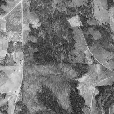
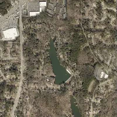
Kenilworth Lake was already full by 1955, ringed by a road with houses on its shore. In 1940 the same valley was woods between terraced farm fields.
- First seen
- Between 1940 and 1955. It is full, with a road around it and houses on the west shore, in the 1955 photo.
- Dam in the lidar
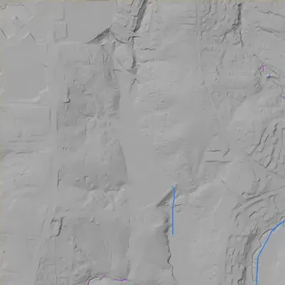
- A straight earth embankment at the southeast end, about 375 ft long along the crest, with a road on top. The crest is about 4 ft above the lake. Lidar puts it about 31 to 36 ft above the ground at its foot. No breach. Overflow leaves by a side spillway on the east shore.
Read from aerial photos taken between 1940 and 2026 and from DeKalb County 2024 lidar, then checked by a second reading. How the photos were read.
Depth
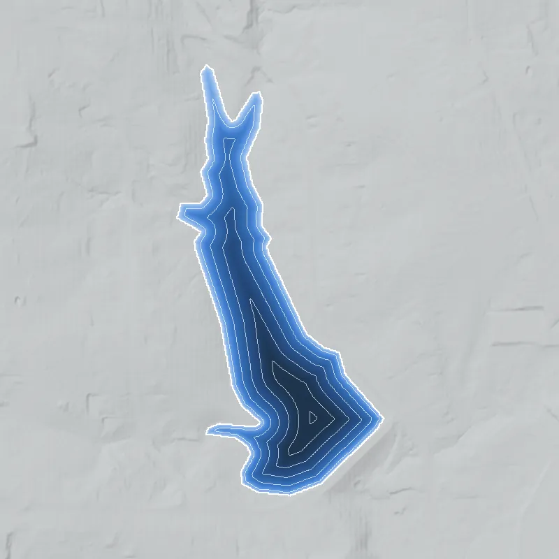
Modeled from the shoreline shape and the dam inventory’s average depth: deepest point about 31 ft. Treat it as an estimate; no survey of the lake bottom was found. How depth is estimated.
History
The federal inventory describes Kenilworth Lake Dam as a 500-foot-long earth dam, 40 feet high, holding a 16-acre lake used for recreation. It lists 1953 as the completion year and 2003 as a modification year. Owners named in the record are DeKalb County's Roads and Drainage Division, the Kenilworth Estates Community Association and a private trust. Georgia regulates it as a high-hazard dam; the last inspection in the record, on March 19, 2019, rated it Satisfactory. Beyond these dam-safety facts, this pass found no history, builder, or plat for the lake, so its story remains to be documented. 1
Who built it
Not established. The NID names the designer as 'DeKalb County/SCS Assitance' (spelled that way in the record). SCS may mean the federal Soil Conservation Service, but that is an inference; the record also says the dam was not built under the Secretary of Agriculture's authority and gives no NRCS watershed-dam authorization. Recreation is the only listed purpose. Who built it, why, and whether 1953 is real are undocumented in the sources reached. The NID stream field says 'South River' with a 169 sq mi drainage area, a figure that is probably not this dam's own watershed, so the impounded stream is not confirmed. 1
Timeline
- 1953Completion year listed in the NID. This is often an estimate in the inventory, and no construction record was found to confirm it. Uncertain 1
- 2003NID records a modification to the dam; the scope, contractor and contract number were not found. 1
- March 19, 2019Georgia Safe Dams inspection recorded in the NID; condition assessment Satisfactory, High hazard classification. 1
Names
- Kenilworth Lake Dam
- Dam name in the National Inventory of Dams (NID); Georgia Safe Dams state ID 044-005-00053. 1
The dam
Earth dam, 40 ft high and 500 ft long. Uncontrolled spillway and uncontrolled outlet. Normal storage 200 acre-ft, maximum storage 294 acre-ft, surface area 16 acres. Modified in 2003 per NID (nature of the work not stated). High hazard potential. State-regulated by the Georgia Safe Dams Program, inspection frequency listed as every 2 years; last inspection in the record March 19, 2019, condition Satisfactory (later inspections may exist but are not in the NID). An Emergency Action Plan is on file. The NID record was last updated April 20, 2021. 1
- Year in the inventory
- 1953
- Dam height
- 40 ft
- Surface
- 16 acres
- Average depth
- about 12.5 ft
- Stream
- South River
- Owner type
- Local Government
Figures from the U.S. Army Corps of Engineers’ National Inventory of Dams. Its “year” is often a rebuild or survey date, and average depth is storage divided by area.
Around the lake
Water
NID lists the stream as South River, unverified for this dam; the 169 sq mi drainage-area figure is too large for a small impoundment and is probably a receiving-river value. No watershed source was reached.
Visiting
Getting there
Not established. The NID lists local government (DeKalb County Roads and Drainage Division) and a community association among the owners, but whether the public can visit was not confirmed.
What you can see
Unknown. The NID shows an earth dam with an uncontrolled spillway; a visitor's view, if any, was not verified.
Look, don’t dig. Parks, cemeteries and preserves are off limits to digging and collecting, and private land needs the owner’s permission to enter.
Open questions
- Who built the dam and lake, and was it 1953 or later? The 'SCS Assitance' designer note may point to a Soil Conservation Service program, which is unconfirmed.
- Is the lake tied to a Kenilworth Estates subdivision plat, and when was that platted?
- What stream actually feeds the lake, since the NID stream and drainage-area fields look unreliable?
- What was the 2003 modification, and was it a County contract?
- What is the ownership split between DeKalb County, the community association, and the private owner, and is any of it open to the public?
- Does the lake appear in the 1938-40 aerials, or was it created after them?
Know something? Write to hello@historyunderfoot.org. Family papers, photos and deeds often settle these.
Where to look next
- National Inventory of Dams record GA01940 (Kenilworth Lake Dam), the source of every dam fact here (USACE National Inventory of Dams, nid.sec.usace.army.mil)
- Georgia Safe Dams Program file for state ID 044-005-00053: permit, inspection reports (2019 and later), Emergency Action Plan, 2003 modification records (Georgia EPD Safe Dams Program (the NID links to the general dam-safety page, which has no dam-specific data))
- DeKalb County Board of Commissioners agendas and contracts for Roads and Drainage work at Kenilworth Lake Dam; a Legistar API title search for 'Kenilworth' returned nothing, so try full-text or Public Works bid records (DeKalb County Legistar and Purchasing)
- Subdivision plat for Kenilworth Estates and adjacent land lots (DeKalb County Clerk of Superior Court plat records; Digital Library of Georgia)
- UGA 1938-40 DeKalb County aerials, to see whether the lake exists before the NID's 1953 date (UGA Libraries Map and Government Information collection)
- USGS 7.5-minute topographic editions of the Stone Mountain quadrangle (1950s to 1970s) to date the lake's first appearance (USGS topoView)
- Georgia Historic Newspapers: a 'Kenilworth Lake' search lists a Georgia Bulletin item (April 11, 1963) and a GA Voice item (August 3, 2012) among hits; most other hits are for other places, and none was checked against this lake (Digital Library of Georgia)
- DeKalb History Center files on Stone Mountain-area lakes and Soil Conservation Service ponds (DeKalb History Center archives, Decatur)
Sources
- National Inventory of Dams full national dataset (CSV, data last updated 2026-9-23), record GA01940 Kenilworth Lake Dam U.S. Army Corps of Engineers, National Inventory of Dams