Dam breached · DeKalb County · Dam inventory GA01329
Key Lake
A 24-foot earth dam near Rock Chapel in east DeKalb, listed in the NID as privately owned, with Davidson Mineral Properties as designer.
Watermark
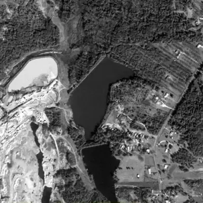
Key Lake, full in 1981
A roughly 14-acre lake behind a straight earthen dam about 24 feet high, up to about 19 feet deep near the dam. Photos show it full from 1968 through the 1990s, beside a growing quarry.
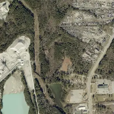
Today: The lake drained between 2001 and 2005 through a notch in the dam. Today the bed is dry brush and young woods, with truck yards nearby.
- Area
- 14.1 acres
- Deepest
- about 19 ft
- Method
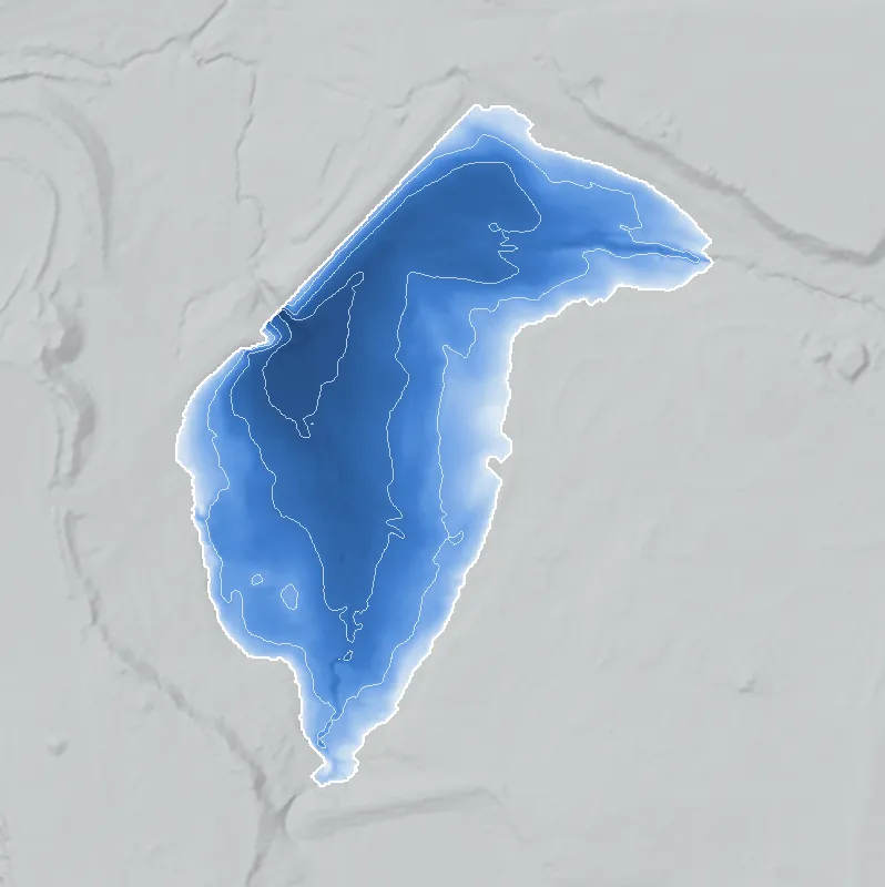
- Refilled from lidar
- Checked against
- 1981 aerial
The old lakebed is still in the ground. The water was put back in the county’s lidar up to the old shoreline, with any broken dam patched, and checked against the 1981 aerial photo. Depth is modeled from today's lidar, not surveyed. The water level is estimated from the dam and shoreline, and the bed has silted and grown over since 2005. How Watermarks work.
From the air
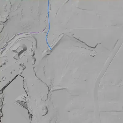
Key Lake drained between 2001 and 2005. A V-shaped notch about 21 feet deep, cut through its 24-foot dam, is the likely breach.
- First seen
- The dam and basin are already there in the 1955 aerial, but open water is only clearly seen in 1968.
- Gone
- The lake was gone by the 2005 aerial, and the bed had no open water by 2017.
- Dam in the lidar
- A straight earth embankment along the northwest shore, about 690 feet long and about 24 feet high, with a crest near 900 to 903 feet elevation. A V-shaped notch near the southwest end, about 60 feet wide, cuts about 21 feet below the crest. It reads as a breach, not a working spillway.
- Depth from the lidar
- The county's 2024 lidar caught the lake bed empty. Assuming a normal water level near 897 feet, the lake was about 16 feet deep at most, with about 13.5 acres. These are modeled from today's surface, not surveyed, and depend on that assumed level.
Low water and drawdowns
- Between 2001 and 2005: Full and green-surfaced in 2001, then bare mud, marsh, sand patches and a thin pool in the northwest arm by 2005. A sandy fan sat at the breach.
- 2005 to 2013: A small leftover pool of about 1 to 1.5 acres stayed in the northwest arm beside the notch, while young pines took over the bed. It was gone by 2017.
Read from aerial photos taken between 1940 and 2026 and from DeKalb County 2024 lidar, then checked by a second reading. How the photos were read.
History
The only source confirmed for this lake is the National Inventory of Dams. It lists Key Lake Dam as a privately owned earth dam, 24 ft high and about 800 ft long, with a 16-acre surface and 104 acre-feet of normal storage. The hazard class is Low and the condition is Not Rated, with an uncontrolled spillway. The NID gives 1950 as completion year and water supply as the purpose. The impounded stream is listed as 'Unknown'. The designer field names Davidson Mineral Properties. No narrative history could be retrieved, so the record here is thin. 1
Who built it
Not established. The NID lists the designer as 'DAVIDSON MINERAL PROPERTIES', completion year 1950 (an unverified NID figure) and primary purpose 'Water Supply'. The impounded stream is 'Unknown'. Nothing retrieved explains why a mineral-property company would want a water-supply pond here, or whether it served a quarry or another use. 1
Timeline
Names
- Davidson Lakes
- Appears only in the map's unit data (its NID-derived 'other name' field). The live NID record retrieved in 2026 lists 'Davidson Minerals' instead, so 'Davidson Lakes' is unconfirmed and no source retrieved uses it.
- Key Lake Dam
- Official NID structure name (the dam, not necessarily the lake's local name). 1
- Davidson Minerals
- NID 'other names' entry; the NID designer field reads 'DAVIDSON MINERAL PROPERTIES'. It may point to a company rather than a lake name, but no source says so. 1
The dam
NID: earth dam, 24 ft structure height, 16 ft hydraulic height, about 800 ft long, uncontrolled spillway and outlet. Maximum storage 136 acre-feet, normal storage 104 acre-feet, surface area 16 acres. Owner type Private. State jurisdiction Yes and state inspection Yes; state permitting No; the NID 'state regulated' flag is No, an inconsistency in the record. Hazard potential Low, condition assessment Not Rated. NID last inspection date May 1, 2005, with a 5-year inspection frequency; record last updated April 20, 2021. State ID 044-060-00799. No rebuild, contract or engineering work found. 1
- Year in the inventory
- 1950
- Dam height
- 24 ft
- Surface
- 16 acres
- Average depth
- about 6.5 ft
- Owner type
- Private
Figures from the U.S. Army Corps of Engineers’ National Inventory of Dams. Its “year” is often a rebuild or survey date, and average depth is storage divided by area.
Around the lake
Water
The NID lists the stream as 'Unknown', so the watershed cannot be stated from the record. Checking the USGS topo quadrangle would settle it.
Visiting
Getting there
Not established. The NID lists private ownership. No park, preserve or public-access page for this lake was found or read.
What you can see
Not established. Nothing retrieved describes what is visible from public roads. A visitor should assume the lake is on private property.
Look, don’t dig. Parks, cemeteries and preserves are off limits to digging and collecting, and private land needs the owner’s permission to enter.
Open questions
- What stream does the dam impound? The NID stream field says 'Unknown'.
- Who is 'Davidson Mineral Properties', and did the 16-acre lake serve a quarry, a mineral operation or a residence?
- Is 1950 the real construction date, or a NID estimate?
- Was the lake ever used for recreation, and under which name did locals call it (Key Lake or Davidson Lakes)?
- Is the lake still full, and has the dam had any state Safe Dams inspection since 2005?
- How does the lake relate to the Rock Chapel community and to nearby land lots?
Know something? Write to hello@historyunderfoot.org. Family papers, photos and deeds often settle these.
Where to look next
- Historic aerial photography of this area from the 1930s-40s onward (if a DeKalb County set exists), to see whether the lake or a dam existed before the NID's 1950 date. Availability not confirmed. (UGA Libraries / Digital Library of Georgia, or USDA/USGS aerial archives)
- USGS topographic quadrangle editions covering 33.731, -84.097 (TopoView holds maps from 1884 to 2006), to see when the lake first appears and what stream it is on (USGS TopoView)
- Georgia EPD Safe Dams Program file for state dam ID 044-060-00799 (inspection reports, classification history) (Georgia EPD Safe Dams Program)
- DeKalb County deed and plat records for the parcel, to identify the owner and any Davidson Mineral Properties conveyance (DeKalb County Superior Court Clerk, real estate records)
- Georgia Historic Newspapers search for 'Key Lake' and 'Davidson' near Rock Chapel / Lithonia (free archive, 1763-2026) (Digital Library of Georgia, Georgia Historic Newspapers)
Sources
- National Inventory of Dams, record GA01329 (Key Lake Dam), Public Service query U.S. Army Corps of Engineers, National Inventory of Dams