Still here · DeKalb County · Dam inventory GA03913
Kings Cliff Lake
A 3-acre lake behind a 28-foot earthen dam beside Henderson Mill school; the state rates the dam high hazard and 'Poor' as of 2021.
From the air
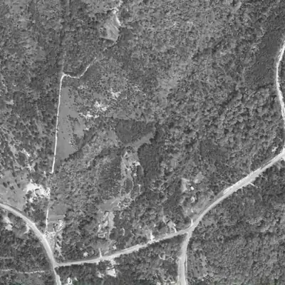
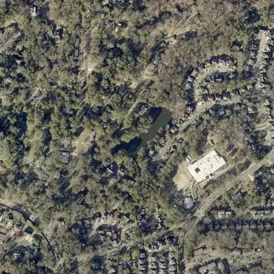
Kings Cliff Lake did not exist in 1955. A 1968 aerial catches its basin bare and freshly graded, and by 1972 it is full of water.
- First seen
- Between 1968 and 1972: a bare graded basin with a fill line at the dam end in 1968, then water by 1972.
- Dam in the lidar
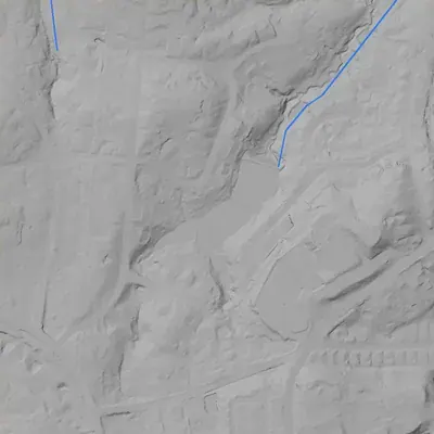
- The county's 2024 lidar survey shows an earthen dam at the northeast end, about 205 feet long. Its crest is near 960 feet, only about 1 foot above the lake. The downstream face drops roughly 26 to 29 feet to the stream below. There is no breach. A low spot at the southeast end may be a spillway (uncertain).
Low water and drawdowns
- Possibly around 2001 (uncertain) possibly: The county aerial shows an olive-tan, grass-like surface instead of dark water. It could be a drawn-down bed, but pollen or algae on full water looks the same. Every later year shows full water.
Read from aerial photos taken between 1940 and 2026 and from DeKalb County 2024 lidar, then checked by a second reading. How the photos were read.
Depth
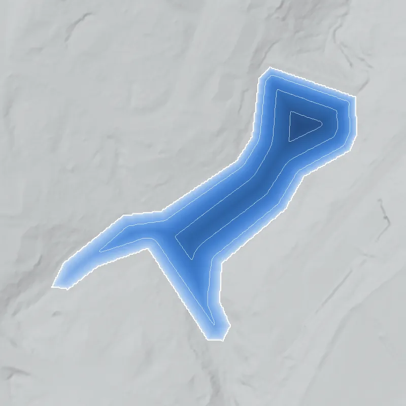
Modeled from the shoreline shape and the dam inventory’s average depth: deepest point about 18 ft. Treat it as an estimate; no survey of the lake bottom was found. How depth is estimated.
History
Kings Cliff Lake is a small lake in the Northlake area of DeKalb County, about 0.4 mile west of the Henderson's Mill site and beside Henderson Mill school. No builder, construction year or original purpose turned up in the record. The USGS map photorevised from 1968 aerial photos shows no lake, only a small stippled patch with a similar elongated outline, while the 1993 quad shows the lake, so it was built between about 1968 and 1993, probably as an amenity for the Woods of Northlake homes. The state lists the 28-foot earthen dam as Category I (high hazard) and rated it 'Poor' at a January 2021 inspection. 1234567
Who built it
Not documented. The USGS Northeast Atlanta sheet (1954 base, revisions compiled from aerial photos taken 1968, issued 1970) shows no lake here, only a small purple-tinted stippled patch with an elongated outline much like the later lake. The 1993 edition shows the lake. So the dam dates from roughly 1968 to 1993. NID lists the year as undetermined, the designer as unknown and the purpose as recreation. A listing site says homes in the adjoining Woods of Northlake were built from 1974 onward, so a subdivision-amenity lake is likely but unproven. NID gives the stream as 'Unknown'; NHD maps an unnamed stream line at the site. 342658
Timeline
- 1825-26Greenville Henderson (1792-1869) moves his family from Morgan County to DeKalb County; a blog says his holdings later exceeded 2,600 acres from Evans Road to Northlake Mall. His mill site lies about 0.4 mile east of this lake. Likely 1011
- July 18, 1864Logan's 15th Army Corps camps at Henderson's Mill on the march from Roswell to Decatur, after withdrawing from Browning's (Tucker) for lack of water, and resumes the march to Decatur the next day. 11
- 1911Henderson's Mill is demolished (state marker); a 2003 article quoted on a local blog says it burned. A concrete structure from the mill-pond dam was reported to remain. 111213
- 1968-1970USGS photorevises the Northeast Atlanta quad from aerial photos taken 1968 and issues it in 1970. No lake appears at the site, only a small purple stippled patch shaped like the later lake, of unclear meaning. 3
- 1971Northlake Mall opens; an article describes a 17-acre lake in its 225-acre development. North Lake, about half a mile east, is already on the 1954 map, so the mall lake is probably older, but the link is unconfirmed. Likely 14432
- 1974 onwardHomes in the neighboring Woods of Northlake are built between 1974 and 2018, according to a listing site; one Kings Arms Court home lists 1992 and is advertised as overlooking a lake. Likely 65
- by 1993The 1993 USGS Northeast Atlanta quad shows the lake beside Henderson Mill school, with a small stream line running northeast from it. 4
- January 7, 2021State inspection records the dam as High hazard, condition 'Poor', with an Emergency Action Plan prepared; NID record updated April 20, 2021. 2
- March 6, 2025A DeKalb committee approves a SPLOST match for a Corps loan to repair Category 1 and 2 dams; the article names no dams, so any tie to this dam is unknown. 9
- June 4, 2025Georgia EPD's dam inventory lists the dam as Category I with owners Key Development and DeKalb County Public Works. 1
Names
- Kingscliff Lake
- Official federal spelling (one word): USGS Geographic Names Information System reservoir, feature ID 1687278, DeKalb County. OpenStreetMap also labels the lake 'Kingscliff Lake'. 1516
- Kings Cliff Lake Dam
- Name used by the National Inventory of Dams and the Georgia EPD Safe Dams inventory (state ID 044-089-02710). 12
The dam
Earth dam, 28 ft high (17 ft hydraulic height), 210 ft long. Normal storage 21 acre-ft, maximum 26 acre-ft, surface 3 acres, uncontrolled spillway and outlet. Georgia Safe Dams Category I (NID: High hazard; the state defines Category I as a dam whose failure would probably cost lives, and it requires EPD permits). Condition 'Poor' at the 01/07/2021 inspection; inspection frequency 2 years; Emergency Action Plan prepared. NID's latest inspection date is still that one as of its September 2026 extract. EPD lists owners as 'Key Development; DeKalb County Public Works Department' from county tax records and warns these may be out of date. In March 2025 a DeKalb committee approved a SPLOST match for a Corps loan for Category 1 and 2 dam repairs, but named no dams. No repair contract or contract number for this dam found. 2179
- Dam height
- 28 ft
- Surface
- 3 acres
- Average depth
- about 7 ft
- Owner type
- Local Government
Figures from the U.S. Army Corps of Engineers’ National Inventory of Dams. Its “year” is often a rebuild or survey date, and average depth is storage divided by area.
Around the lake
Water
NID gives the stream as 'Unknown'; NHD shows an unnamed stream line beside the site. Named streams within about 2.5 km include Henderson Mill Creek, Burnt Fork Creek and North Fork Peachtree Creek. The 1993 quad draws a stream running northeast from the lake toward a creek near North Lake; Henderson Mill Creek is likely but not confirmed.
Civil War
About 0.4 mile east, Logan's 15th Army Corps camped at Henderson's Mill on July 18, 1864, per the Georgia marker (HMDB). The lake itself is modern.
Before 1861
Lies in the area Greenville Henderson (1792-1869) farmed after arriving in 1825-26; his grist mill stood beside Henderson Mill Road, near Midvale Road. Whether this parcel was part of his holdings was not verified.
Visiting
Getting there
No park or public access found. The lake is surrounded by residential streets (Kingscliff Drive, Kingscliff Way, Kings Arms Court). EPD lists DeKalb County and a developer as owners from tax records that may be out of date; one listing site calls it a homeowners' association lake and another says the community has no HOA, so actual control and any public access are unconfirmed. Look from public streets only.
What you can see
Unverified on site. Records describe a 210-foot earthen dam with an open, uncontrolled spillway and a lake of about 3 acres, drawn beside Henderson Mill school on the 1993 map. Nearby, a Georgia marker for Henderson's Mill stands at 2601 Henderson Mill Road.
Look, don’t dig. Parks, cemeteries and preserves are off limits to digging and collecting, and private land needs the owner’s permission to enter.
Open questions
- Who built the dam, in what year, and for which development (Northlake Mall-era planning, Woods of Northlake, or another developer)?
- Which entity actually owns and maintains the dam today, given the mixed developer and county owner listing?
- Which named creek does the outflow reach, and where was the original stream channel before the dam?
- What were the specific deficiencies behind the 2021 'Poor' rating, and has any repair been designed or funded?
- What is the small purple stippled patch at the site on the 1968-revised map, and does it mark early clearing of the lake basin?
Know something? Write to hello@historyunderfoot.org. Family papers, photos and deeds often settle these.
Where to look next
- USGS Northeast Atlanta 1:24,000 quads: the 1954 sheet photorevised 1968 (three catalog copies) versus the 1993 and 1997 editions; check for any intermediate edition to narrow the build date (USGS Historical Topographic Map Collection (TopoView))
- Georgia EPD Safe Dams permit and inspection file for state ID 044-089-02710 (construction permit, plans, engineer, inspection reports, EAP); request via Open Records (Georgia EPD Safe Dams Program)
- Plat for Woods of Northlake / Kingscliff sections and any dam or lake easement recorded with them; check whether 'Key Development' appears as grantor (DeKalb County Superior Court Clerk, plat books and deed records; DeKalb GIS parcel layer)
- 1970s-80s rezoning and preliminary plat cases for the Kings Arms / Kingscliff tracts off Henderson Mill Road (DeKalb County Planning and Zoning archives; DeKalb History Center)
- Historic aerials: UGA 1938-40 DeKalb County set (before development) and later USGS/NAPP frames from the 1970s-80s to see the lake basin being cleared or filled (UGA Libraries Map and Government Information Library; USGS EarthExplorer)
- Henderson Mill subject file (mills) and other Northlake files (scanned PDF, no text layer) (DeKalb History Center archives)
- Northlake Mall / Northlake development announcements 1969-1972 that may describe residential phases and lakes (Georgia Historic Newspapers (Decatur-DeKalb News Era) and Atlanta History Center newspaper files)
- DeKalb SPLOST match for Category 1 and 2 dam repairs (2025 Corps CWIFP loan application); check whether this dam is on the project list (DeKalb County Public Works and Infrastructure Committee agendas and Legistar)
Sources
- Dam Inventory (Safe Dams Program), updated June 4, 2025 Georgia Environmental Protection Division
- National Inventory of Dams: records GA03913 (Kings Cliff Lake Dam), GA03915 (Robert Nash Lake Dam) and GA02051 (North Lake Dam), national CSV data last updated 2026-9-23 U.S. Army Corps of Engineers
- USGS 1:24000 Quadrangle for Northeast Atlanta, GA 1954 (photorevised 1968; revisions from aerial photos taken 1968; printed 1970) U.S. Geological Survey
- USGS 1:24000 Quadrangle for Northeast Atlanta, GA 1993 U.S. Geological Survey
- 3117 Kings Arms Court NE listing (subdivision Woods of Northlake, built 1992, lake views) Intown Elite (real-estate listing)
- Woods of Northlake subdivision in Atlanta, GA Homes by Marco (real-estate site)
- Safe Dams Program Georgia Environmental Protection Division
- National Hydrography Dataset services (large-scale waterbody and flowline queries at both dam points) U.S. Geological Survey
- PWI committee approves lead-investigation loan, dam-match, and three major water contracts (March 6, 2025) Citizen Portal
- The City of Tucker Initiative: Greenville Henderson of Henderson's Mill Fame City of Tucker Initiative blog
- Site: Henderson's Mill Historical Marker (2601 Henderson Mill Road) Historical Marker Database
- Henderson family and Henderson's Mill Past Tense GA
- Northlake Station: Henderson's Mill Site 'Preserved' but not dedicated Northlake Station blog
- Northlake Mall of 1971 and today Past Tense GA
- GNIS / National Map Gazetteer: Kingscliff Lake (feature ID 1687278) and North Lake (feature ID 339133), reservoirs, DeKalb County U.S. Geological Survey
- OpenStreetMap geocoding (Nominatim) for Kings Arms Court, Kingscliff Drive/Way, Gleneagles Drive, Dedee Court, Robert Nash Court OpenStreetMap contributors