Still here · DeKalb County · Location approximate
Lake Avondale
Avondale Estates' centerpiece lake, built by developer George F. Willis by January 1926 and deeded to the city in 1928; dam repairs planned for 2026.
From the air
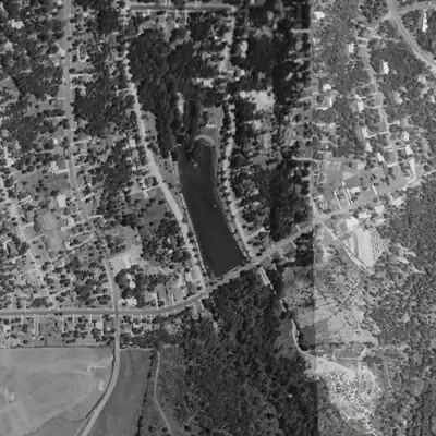
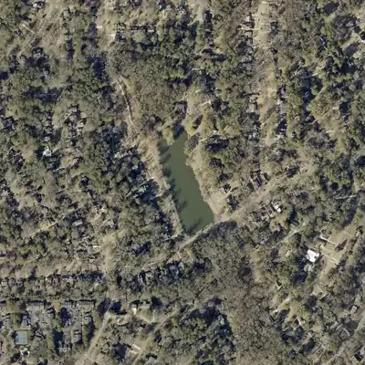
Lake Avondale looks the same in every aerial from 1955 to 2026. Its road-topped dam has gullies cut into the downstream face, up to about 20 feet below the road.
- First seen
- The lake and its dam road are already in place in the earliest aerial, from 1955.
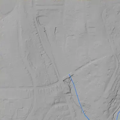
- Dam in the lidar
- The dam is the road embankment along the south end, about 260 feet along the pool and 360 feet including the ends. The level crest is about 983 feet, 4 to 5 feet above the water. The downstream drop is about 13 feet to a bench and up to about 20 feet at the gully floor. No breach or spillway notch shows.
Read from aerial photos taken between 1940 and 2026 and from DeKalb County 2024 lidar, then checked by a second reading. How the photos were read.
History
Lake Avondale was the recreation centerpiece of Avondale Estates, the Tudor-style planned suburb George F. Willis began in 1924 on the old Ingleside community. A city historic survey says Willis had built a lake by January 1926, alongside a park with pool, tennis courts and playground, and had started a lakeside boathouse clubhouse. Decaturish reports the lake was deeded to the city in 1928. WPA labor later landscaped its banks. The lake lies inside the National Register historic district (listed 1986). After 2024 and April 2026 engineering studies, the city plans tree removal and a French drain on the nearly century-old dam. 12345
Who built it
Developer George Francis Willis (1879-1932), who made his fortune in patent medicines, bought roughly 1,000 acres in January 1924 (Phase II survey; a DeKalb History Center piece says 950 acres) that included farms and a small rural community named Ingleside. He planned a suburb with park amenities. A city survey says that by January 1926 he had built a lake, a park with pool, poolhouse, tennis courts and playground, and had begun a lakeside boathouse clubhouse. USGS NHD maps the lake on Cobbs Creek, and mapped area of about 0.017 sq km (roughly 4 acres). The sources read do not name the dam's engineer or contractor or give a completion year. 2634
Timeline
- 1890sLots are sold in the area then known as Ingleside, the community Willis would later buy to create Avondale Estates. Source is Wikipedia only. Likely 7
- January 1924George F. Willis, an Atlanta businessman and member of the Stone Mountain Memorial Association, buys about 1,000 acres in DeKalb County (Phase II survey; DeKalb History Center says 950) including the small community of Ingleside. 23
- January 1926A city historic survey says Willis had by now built a park with pool, poolhouse, tennis courts and playground, and a lake, and that construction of a lakeside boathouse clubhouse had begun. 4
- August 25, 1926The Georgia General Assembly approves an act creating the Avondale Estates city charter. 8
- September 20 - November 1, 1927A referendum called for September 20 adopts the charter; the first mayor and board of commissioners are elected on November 1. 8
- October 16, 1927Crews break ground on Stone Mountain Memorial Drive, the highway to Stone Mountain that was to run through Willis's development, in a ceremony led by the Stone Mountain Memorial Association. 2
- January 1, 1928The city charter takes effect. 8
- 1928The lake is deeded to the city, according to Decaturish reporting; the source does not say who deeded it or on what terms. 1
- Late 1930s-early 1940s (WPA years)The city's Phase I survey says the Works Progress Administration provided labor for planting the Abelia hedge and landscaping the banks of Lake Avondale and surrounding land. Exact years are not given; the WPA operated 1935-1943. Likely 4
- December 8, 1986The Avondale Estates Historic District, whose boundary description includes Lake Avondale, is listed on the National Register of Historic Places (ref. 86003669). Date and reference are from a Wikipedia list; the city survey confirms a 1986 listing. 35
- 2024Dewberry Engineers inspects the lake's dam. 1
- April 2026A geotechnical subsurface investigation of the dam is conducted by Dewberry. 1
- May 13, 2026The city commission hears the findings: tree removal, vegetation clearing, a French drain and erosion repair near the outfall by Wiltshire Drive. Decaturish reports it May 14 and updates the story May 26. 1
- August 29, 2026The city's centennial program schedules a 1920s Gala at the Lake House on Lake Avondale, part of a celebration running August 2026 through January 2028. 8
Names
- Avondale Lake
- Name of the waterbody (GNIS ID 325870, type LakePond) in the USGS National Hydrography Dataset, which is the source of this map's coordinates. 6
- Lake Avondale (Avondale Estates Historic District)
- The National Register listing for the historic district gives its boundary as 'Roughly bounded by Avondale Rd., Lakeshore Dr., Kingstone, Clarendon, and Fairchild Dr., also Lake Avondale'. 5
The dam
Decaturish reports the lake is nearly 100 years old. Dewberry Engineers inspected the dam in 2024 and ran a geotechnical subsurface investigation in April 2026, finding significant erosion near the pipe outfall that could affect Wiltshire Drive. At its May 13, 2026 meeting the city commission discussed removing large trees on the dam, clearing overgrown vegetation and installing a French drain to handle seepage that tree removal would increase. Work is in two phases, possibly concurrent, lasting about six months, with funds already in the city budget. Height, spillway type, Safe Dams classification and contract numbers were not found; the dam is not in the NID file used for this map. Whether the work has started as of late September 2026 is not confirmed. 1
Around the lake
Water
NHD shows the lake as a small impoundment of about 0.017 sq km on Cobbs Creek, in the South River basin (NHD reach 03070103). Wikipedia (likely, not corroborated) says granite outcrops can be seen along the lake's shore.
Segregation
The DeKalb History Center's exhibit on Avondale Estates (Aug 2021 - June 2025) says the town was developed as an intentional 'Whites Only' exclusive enclave. Its 2018 blog says marketing targeted 'families of proven standing and financial responsibility.' Whether the lake, pool or clubhouse had separate written access rules was not found.
Before 1861
The lake area was part of Ingleside, a small rural community among several large farms per the city survey; Wikipedia says lots were sold there in the 1890s. Pre-1860 land lots, mills and roads on the lake site were not found in the sources read.
Visiting
Today
City-owned lake and park in Avondale Estates.
Getting there
City-owned lake and park in Avondale Estates, deeded to the city in 1928. The Lake House on the lake hosts city events, including the August 29, 2026 centennial gala. Hours, fishing rules, boating and rental terms were not confirmed; check the city website or call city hall.
What you can see
The lake, its dam and the Wiltshire Drive embankment, and the Tudor-style neighborhood around the lake. Tree removal and a French drain are expected to change the dam's look once the roughly six-month work happens. The sources read do not describe a spillway, markers or ruins. No historical marker for the lake turned up in the HMDB town list (only other Avondale Estates markers appeared; the marker pages themselves could not be re-checked).
What to look for
The dam along Wiltshire Drive at the lake's outlet.
Look, don’t dig. Parks, cemeteries and preserves are off limits to digging and collecting, and private land needs the owner’s permission to enter.
Open questions
- Who designed and built the dam (engineer, contractor) and in what year, given a lake existed by January 1926?
- Who deeded the lake to the city in 1928, and were any deed restrictions attached?
- Were the lake, pool and boathouse ever restricted by race, and when and how did access change?
- What are the dam's height, spillway type, hazard classification and Georgia Safe Dams status, and why is it absent from the NID file?
- Which WPA project or projects landscaped the shoreline, and in what years?
- Were there earlier drawdowns, repairs, dredging or breaches before the 2024-26 assessments?
- Did a mill pond or earlier impoundment exist on Cobbs Creek at this site before 1924?
- Has the 2026 tree removal and French drain work started, and what was the final cost and contractor?
Know something? Write to hello@historyunderfoot.org. Family papers, photos and deeds often settle these.
Where to look next
- City Historic Resource Inventory Study, Phase I and II reports (lake, park, boathouse clubhouse, WPA landscaping) and 48 street files including Lakeshore Drive, Lakeshore Plaza and Wiltshire Drive (City of Avondale Estates Historic Preservation Commission)
- National Register nomination for the Avondale Estates Historic District (1986, ref. 86003669), which should describe the lake and its structures (National Park Service / Georgia Historic Preservation Division)
- City Commission agendas and packets for the May 13, 2026 meeting, with the Dewberry dam findings and any bid or contract number (City of Avondale Estates, Board of Mayor and Commissioners agendas and minutes)
- Avondale Estates, The Haven of Health and Happiness exhibit (2021-2025) and its research files, including the segregation history (DeKalb History Center, Decatur)
- 1920s Avondale Estates promotional brochures and Atlanta Constitution coverage of the lake's building and opening (Georgia Historic Newspapers / Digital Library of Georgia; DeKalb History Center archives)
- Historic aerials of the lake and dam: UGA 1938-40 DeKalb County aerial series; USGS topo editions for pre- and post-lake shorelines (UGA Libraries Map and Government Information collection; USGS TopoView)
- Georgia EPD Safe Dams Program file for the Lake Avondale dam, to check for a permit or classification (Georgia Environmental Protection Division, Safe Dams Program)
- Plats of Avondale Estates and DeKalb County deed records for the 1928 deed of the lake (DeKalb County Superior Court Clerk, plat and deed records)
Sources
- Avondale Estates commission discusses fixing Lake Avondale dam (Decaturish, May 14, 2026, updated May 26) Decaturish
- Memorial Drive: History from Atlanta to Stone Mountain DeKalb History Center
- Avondale Estates Historic Resource Survey, Phase II report City of Avondale Estates
- Avondale Estates Historic Resource Survey, Phase I report City of Avondale Estates
- National Register of Historic Places listings in DeKalb County, Georgia (Avondale Estates Historic District, ref. 86003669) Wikipedia
- USGS National Hydrography Dataset (NHD) MapServer: waterbody 'Avondale Lake' (GNIS 325870) and Cobbs Creek flowline U.S. Geological Survey
- Avondale Estates, Georgia Wikipedia
- Avondale Estates Centennial Celebration City of Avondale Estates