Dam breached · Fulton County · Dam inventory GA01954
Lake Charlotte
Estate lake on a 1928 map. Atlanta bought it in 1977, breached the dam in 1982; it is now marsh in a city preserve.
Watermark
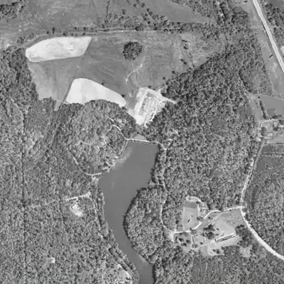
Lake Charlotte, full in 1955
A roughly 10-acre lake filled the valley behind an earthen dam about 27 feet high. It was up to 23 feet deep and a long, narrow tail ran south. Full in every photo from 1940 to 1981; drained 1982.
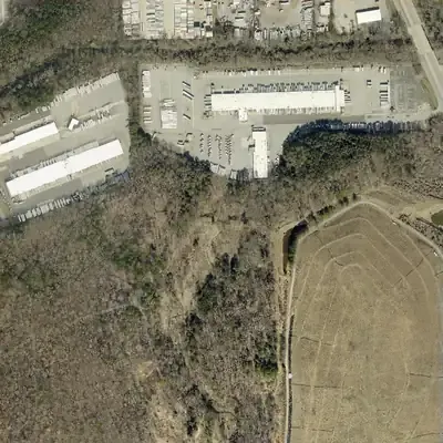
Today: The dam still stands with a V-shaped gap cut through it. The old lakebed is a sandy flat with a small stream, grass and brush, inside a city forest preserve beside a landfill.
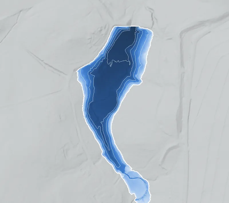
- Area
- 9.5 acres
- Deepest
- about 23 ft
- Method
- Refilled from lidar
- Checked against
- 1955 aerial
The old lakebed is still in the ground. The water was put back in the county’s lidar up to the old shoreline, with any broken dam patched, and checked against the 1955 aerial photo. Pool level of about 811 feet is estimated by matching lidar to the old shoreline, give or take 2 feet. The lake's southern tail runs past the map edge, so full size is uncertain. How Watermarks work.
From the air
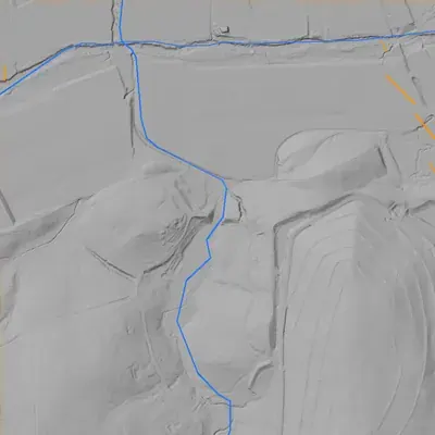
Lake Charlotte's dam still stands with a clean V-shaped breach, cut about 28 feet below its crest. The lake was full in 1981 and gone by 1993.
- First seen
- Already there in the earliest aerial photo, 1940; a researched 1928 map calls it Mount Manor Lake, which the photos cannot confirm.
- Gone
- Full in 1981 and dry by 1993, which fits the recorded 1982 breach.
- Dam in the lidar
- Earthen dam at the north end, about 335 feet long and 27 feet high, with a crest near 816 feet elevation. A V-shaped breach cuts through the middle, about 40-50 feet wide at the bottom and 110-125 feet wide at crest level. The original spillway is not visible.
- Depth from the lidar
- The county's 2024 lidar shows the empty bed, not a water surface. The old pool was probably near 811 feet, give or take 2, so about 21-23 feet deep at the dam. Treat these as minimums, since sediment may have built up on the floor.
Low water and drawdowns
- Between 1981 and 1993 (permanent): A full, dark pool with an unbroken dam crest in 1981. No water and a gap in the dam in 1993. This fits the recorded 1982 breach.
Read from aerial photos taken between 1940 and 2026 and from DeKalb County 2024 lidar, then checked by a second reading. How the photos were read.
History
Lake Charlotte began as Mount Manor Lake, shown on a 1928 map with structures overlooking it. Atlanta Magazine says six country estates surrounded a lake here in the 1920s. Maps called it Lake Charlotte by 1960. Atlanta bought the roughly 10-acre lake and 40 surrounding acres in 1977, breached the earthen dam in 1982, and sold the land in 1986. Waste Management bought it in 1989, next to its Live Oak landfill, and the forest stayed behind a padlocked fence for decades. The Conservation Fund bought the 216-acre forest in 2019 and sold it to the city in 2020. The preserve opened in October 2021. The dam and a marsh remain. Who built the dam is not in the sources found. 1234567
Who built it
The record does not say who built the dam or when. Southern Cultures found structures overlooking 'Mount Manor Lake' on a 1927-30 topographic map (cited as 1928) and names Atlanta dentist Dr. R. F. Ingram as president of the Mount Manor Estates Fishing Club, without dating his term. Atlanta Magazine says six country estates surrounded a lake in the 1920s in a then-remote part of Fulton County. That suggests an estate and fishing-club lake rather than a mill or utility reservoir, though no source states its purpose at creation. The dam impounds a small tributary of the South River. NID's 1950 completion year conflicts with the 1928 map and may be a rebuild, a repair or an inventory guess. It is not an origin date. 156
Timeline
- 1920sAtlanta Magazine says six country estates were dotted around a lake in a then-remote pocket of Fulton County. It does not name the builder of the lake or dam, and none of the sources found does. Likely 5
- 1928Southern Cultures' author finds structures along the road overlooking 'Mount Manor Lake' on a historic topographic map, cited as Emory's Atlanta 1927-30 topographic maps. The road was Woodsey Way, later Ingram Drive. 1
- UndatedDr. R. F. Ingram, an Atlanta dentist and businessman, is president of the Mount Manor Estates Fishing Club, according to Southern Cultures. The article gives no dates for his presidency. 1
- 1937-1956Ingram's only granddaughter, Charlotte Sage, is an Ansley Park debutante in 1937. Southern Cultures says she died in 1956, aged 37, 'without a husband or heirs', and notes her 1948 wedding to a naval officer. 1
- 1950sAtlanta Magazine says Atlanta annexed the property in the 1950s. NID's 1950 completion year for the dam conflicts with the 1928 map and may reflect a rebuild or an inventory guess. Uncertain 56
- By 1960'Lake Charlotte' appears on Atlanta maps, which Southern Cultures calls a 'watery tribute'. That it honors Charlotte Sage is the author's inference, not a documented naming record. Likely 1
- 1973Soapstone Ridge, an ancient quarry area, is listed on the National Register of Historic Places, per Wikipedia. The Conservation Fund says the forest's southern boundary runs along the ridge. Whether the listing boundary covers the preserve is unconfirmed. Likely 93
- 1977Parks director Ted Mastroianni uses federal and state grants to buy the ten-acre lake and forty surrounding acres for a public nature preserve. 17
- 1982The city breaches the earthen dam and drains the lake, officially under the 'US Safe Dams Act'. Southern Cultures adds that 1980-81 killings at and near the lake gave it a haunted reputation. 12
- 1986Atlanta scraps the park plan, saying 'the unattended nature of the park attracts illicit acts', and sells the land at a loss to developer Herman Lischkoff. The Live Oak landfill opens the same year. 15
- 1989Waste Management buys the forest next to Live Oak, 'anticipating future expansion'. The property stays behind a padlocked fence for decades and is closed to the public. 13
- 1993-2007In 1993 the city denies Waste Management's permit to expand onto the Lake Charlotte land, and the landfill grows upward. Georgia EPD orders Live Oak shut in 2003. Methane harvesting starts in 2007. 1
- December 2019The Conservation Fund buys the 216-acre forest from Waste Management. It calls this its single largest purchase to conserve greenspace in Atlanta to date. 473
- April 20, 2020Atlanta City Council approves buying the forest with the city's tree recompense fund. Legislation is cited as 20-O-1216. The Conservation Fund's news release, dated April 22, reports the approval. 10411
- August 24, 2020The city signs the paperwork to buy the forest from the Conservation Fund 'for the same price'. Reported figures are about $4.5 million (Conservation Fund) and $4.7 million for land plus $625,000 for security (SaportaReport). 7411
- October 2021After a neighborhood walkthrough arranged by Councilmember Joyce Sheperd, the city considers the preserve open. The first phase is a short loop trail, with more planned. 212
- 2023-2026City Forest Credits lists 36,265 forest carbon credits for 2023-2026 (9,239 a year for 2023-2025), with 196 of the preserve's 216 acres in the project. None had been sold as of June 2026. 13
Names
- Mount Manor Lake
- Name on a 1928 map, per Southern Cultures, which cites 'Atlanta 1927-30 Topographic Maps with Open Street Map Overlay' from Emory's Center for Digital Scholarship. The 'Mount Manor Estates Fishing Club' is tied to the same lake. 1
- Lake Charlotte
- On Atlanta maps by 1960. Southern Cultures calls the name a 'watery tribute' and ties it to Charlotte Sage (d. 1956), granddaughter of Dr. R. F. Ingram. That link is the author's inference, with no naming record cited. 1
- Lake Charlotte Dam
- Name in the National Inventory of Dams (NID ID GA01954, state ID 060-096-01086). It lists no other or former names. 6
The dam
NID: earthen dam, 29 ft dam height (30 ft hydraulic and structural), 320 ft long, uncontrolled spillway and outlet. NID lists 9.6 surface acres, 131 acre-ft normal storage and 380 acre-ft maximum. Owner is City of Atlanta, purpose Recreation, hazard 'Undetermined', condition 'Not Rated', designer unknown, state-regulated 'No', record last updated 04/20/2021. NID's 421 sq mi drainage area is implausible for a small tributary and is probably a data error (possibly a South River basin figure). Georgia EPD says a structure is a dam under the Georgia Safe Dams Act if it is at least 25 ft tall or stores at least 100 acre-ft, so this one met the definition while it held water. Only Category I dams (probable loss of life if they fail) need EPD permits. Southern Cultures says the city breached the dam in 1982 'in compliance with the US Safe Dams Act', its own phrasing. On the 2021 visit, Saporta Report's writer stood on the old earthen dam. No rebuild or repair records were found. 1268
- Year in the inventory
- 1950
- Dam height
- 29 ft
- Surface
- 9.6 acres
- Average depth
- about 13.6 ft
- Stream
- Tr-South River
- Owner type
- Local Government
Figures from the U.S. Army Corps of Engineers’ National Inventory of Dams. Its “year” is often a rebuild or survey date, and average depth is storage divided by area.
Around the lake
Water
NID lists the impounded stream as 'Tr-South River'. A hiker in 2022 describes a tributary stream of the South River running north through the property. Saporta Report describes the former lake as marshland seen from the old dam. The preserve is the acquisition Saporta Report calls a cornerstone of the proposed South River Forest, a 3,500-acre plan in the South River watershed.
Civil War
Nothing sourced places 1864 fighting on the lake itself. GHS marker 044-59 at Fayetteville Road and Fleetwood Drive in Fulton County records Hardee's corps turning northeast there on July 21, 1864, before the Battle of Atlanta; the Georgia Historical Society database lists that marker as currently not in place. Cobb's Mill, on Intrenchment Creek, is on marker 044-58 at 1510 Key Road in DeKalb County. This is regional context, not a documented tie to the lake, and no distances were checked.
Segregation
Southern Cultures says the 1979-81 child murders 'deepened Whites' fears about the dangers of the inner city, accelerating White flight', and that 'an entire generation of Black residents learned to fear and avoid Atlanta's forests and rivers.' It also says the Lake Charlotte property was 'the only buffer between the reeking dump and backyards in South River Gardens, a predominantly Black neighborhood.' Residents organized against the 1993 expansion permit. No source found on whether the fishing club or estates were racially restricted.
Before 1861
The Conservation Fund says the forest's southern boundary runs along Soapstone Ridge, with Native American soapstone quarries and workshops it dates to about 3000 BC. Southern Cultures and Wikipedia give 1500-600 BCE for the Late Archaic quarrying. The ridge was listed on the National Register in 1973 (Wikipedia). Site locations are not given here, and the preserve is a no-dig area. No pre-1900 land-lot, mill or road history was found for the lake basin.
Visiting
Getting there
City of Atlanta public nature preserve of about 216 acres. The City lists the trail entrance, called Woodsey Way, at 3018 Forrest Park Road SE, with a main gate about 1,000 ft north on that road. Parking is on the street along Forrest Park Road near the signage. Hours were not found, and the City parks page could not be read. A visitor in August 2025 found a broad gravel main trail with spurs and advised not leaving valuables in the car, since the area had seen dumping. The 2021 opening was a soft, phased one, with more trail phases planned. Status as of late 2026 is not confirmed beyond a June 2026 registry page still listing the City as owner.
What you can see
The old earthen dam and the marsh where the lake was, seen from the dam. Old roads serve as trails. Hikers report low stone walls and terraces, stone stairs, a stone chimney, a house foundation, hearths and iron pipes. WABE describes a vine-covered light pole and a dead-end sign, and Saporta Report a cleared area where hunting lodges and cottages stood until recently. Planted daffodils show up in spring. Trees include white oak, shagbark hickory, black oak and American beech. No historical marker was found. This is a no-dig preserve, so look but do not disturb the ruins.
Look, don’t dig. Parks, cemeteries and preserves are off limits to digging and collecting, and private land needs the owner’s permission to enter.
Open questions
- Who built the dam, and when? The 1920s date is inferred from the 1928 map and Atlanta Magazine, and NID's 1950 year is unexplained.
- Did a rebuild or repair happen around 1950, or is 1950 only an inventory date?
- How was the 1982 breach done, and what Georgia EPD (Safe Dams) file or order supports the 'compliance' reason? Southern Cultures says 'US Safe Dams Act'. Georgia's Act is O.C.G.A. 12-5-370 et seq. NID shows the dam as not state-regulated, hazard 'Undetermined'.
- Was 'Lake Charlotte' named for Charlotte Sage? The author of Southern Cultures calls it a 'tribute' but cites no naming record. The article's 'without a husband or heirs' sits oddly beside a 1948 marriage.
- Were the Mount Manor estates or fishing club racially restricted?
- What do the Atlanta 1975 parks report and the 1977 grants say about the price and boundary of the purchase? Did the city ever open the park between 1977 and 1982?
- Is any of the dam still standing at its original height, and is its spillway intact? Sources only say an old dam is visible.
- Drainage date: Atlanta Magazine puts it in the child-murders era of the 1970s and says the landfill closed in 2004; Southern Cultures says 1982 and an EPD order in 2003. The 1982 date has the better documentation.
Know something? Write to hello@historyunderfoot.org. Family papers, photos and deeds often settle these.
Where to look next
- 1927-30 Atlanta topographic maps showing 'Mount Manor Lake', cited by Southern Cultures as held by Emory's Center for Digital Scholarship. Try OpenWorld Atlanta. (Emory Center for Digital Scholarship, OpenWorld Atlanta)
- Historic aerials and USGS topo editions from the 1940s-60s to date the dam and the 'Lake Charlotte' label. UGA 1938-40 DeKalb aerials may cover only the DeKalb side, and the GSU 1949 Atlanta aerial should show the lake near its NID date. (UGA Map & Government Information Library, GSU Library 1949 Atlanta aerials, USGS topoView)
- AJC and Atlanta Constitution articles (society pages 1930s-50s; 1986-2003 coverage of the sale, landfill and permits). Searching Georgia Historic Newspapers for 'Mount Manor' found nothing. (Atlanta History Center Kenan Research Center; newspaper databases)
- City Council legislation 20-O-1216 (2020 acquisition), plus the stewardship plan and tree-fund legislation. Also the 1977 grant papers. (Atlanta City Council Legistar; Atlanta Bureau of Parks 1975 Annual Report)
- State dam file 060-096-01086 and the 1982 breach order, to see the Safe Dams basis. Also the Fulton County deed chain (Ingram, city, Lischkoff, Waste Management). (Georgia EPD Safe Dams Program; Fulton County Clerk / GIS)
- 'Soapstone Ridge: Its Environment and Land Use' (1976), for context on the ridge and its local surveys. Not for site locations. (DeKalb County Planning Department)
Sources
- The Lake and the Landfill (Hannah S. Palmer, Southern Cultures, 2021) Southern Cultures / UNC Press
- Inside Lake Charlotte, the City's new nature preserve (Nov 8, 2021) SaportaReport
- Protecting One of Atlanta's Largest Mature Forests The Conservation Fund
- One of Atlanta's Largest Remaining Forests Protected (April 2020) The Conservation Fund
- One of Atlanta's largest remaining forests has been saved. Now what? Atlanta Magazine
- National Inventory of Dams national CSV, record GA01954 (data updated 2026-09-23; record updated 04/20/2021) US Army Corps of Engineers
- With Big New Park, Atlanta Protects A Forest With A Long History (Molly Samuel, Aug 25, 2020) WABE
- Georgia Safe Dams Program Georgia EPD
- Soapstone Ridge (Wikipedia; lead, NRHP ref. 73002138, listed May 7, 1973) Wikipedia
- One of Atlanta's Largest Remaining Forests Protected City of Atlanta Department of City Planning
- 216-acre southeast Atlanta forest headed for permanent preservation (Maggie Lee, Mar 30, 2020) SaportaReport
- Lake Charlotte Nature Preserve, Southeast Atlanta's huge forest, opens to the public (Nov 2, 2021) SaportaReport
- Lake Charlotte Nature Preserve carbon registry page (updated June 10, 2026) City Forest Credits
- South River Atlanta Urban Conservation The Nature Conservancy in Georgia