Still here · City of Atlanta · Location approximate
Lake Clara Meer (Piedmont Park)
Piedmont Park's spring-fed lake, begun as a small pond in 1887 and enlarged to about 11.5 acres for the 1895 Cotton States Exposition. Swimming reportedly ended in 1973.
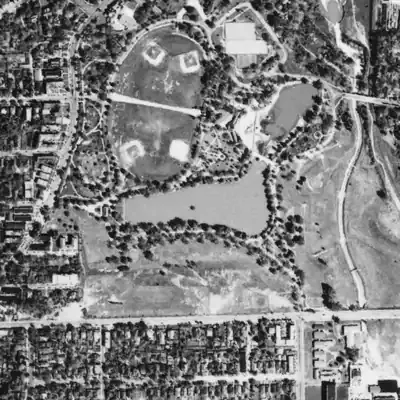
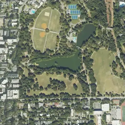
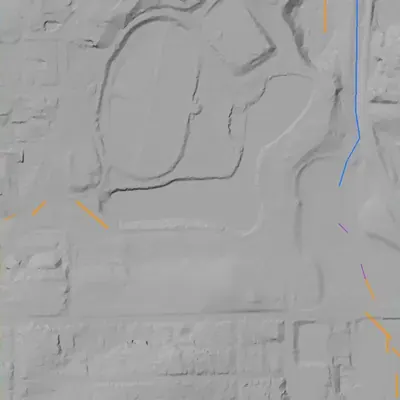
From the air
Clear Creek once ran in an open concrete ditch beside the lake. By 2001 it was gone, probably buried in a pipe, and the lake sits 15 to 22 feet above its old valley.
- First seen
- The earliest aerial, from 1940, already shows the lake; the written record dates it to 1887 and 1895.
- Dam in the lidar
- A broad earthen embankment appears to hold the lake along its east side, about 25 feet high at most (17 to 20 feet along the south lake). The crest is near 881 to 887 feet, against a 877-foot water level. No breach or spillway is visible. That it is an engineered dam is an inference from the terrain; it is not in the national dam inventory.
Read from aerial photos taken between 1940 and 2026 and from USGS 3DEP lidar, then checked by a second reading. How the photos were read.
History
Lake Clara Meer began in 1887 as a small lake fed by a spring near today's Visitor Center. For the 1895 Cotton States Exposition it was enlarged to about 11.5 acres and named. The Conservancy says a wooden bathhouse for swimmers went up in 1911 and was later replaced by the current stone one in 1926. Wikipedia says swimming lasted until 1973, when the city opened a park pool. The Conservancy's 2025 plan calls for dredging 5 to 10 feet of sediment, a loop boardwalk, and possible boat rentals. The lake is not in the National Inventory of Dams. 12345
Who built it
A spring branch of the Clear Creek system was ponded. The Conservancy dates a small lake to 1887 (a spring near the Visitor Center) and the enlargement and naming to 1895. Wikipedia's Clear Creek article says the branch was dammed in 1894. Wikipedia says the original park was designed by Joseph Forsyth Johnson for the first exposition, held on land the Gentlemen's Driving Club bought in 1887. No source read says who engineered the dam. 12637
Timeline
- 1834Sarah and Samuel Walker buy land that later becomes part of Piedmont Park, after the forced removal of Muscogee Creek people. The 2025 plan says a mill below today's Legacy Fountain was powered by Clear Creek. 7
- October 10, 1887Wikipedia says the first Piedmont Exposition opened on this date on land the Gentlemen's Driving Club (now the Piedmont Driving Club) had bought that year; the 2025 plan confirms the 1887 sale. Likely 278
- 1887A small lake is made from a spring flowing into the park near today's Visitor Center, according to the Piedmont Park Conservancy. 1
- 1894Wikipedia's Clear Creek article says the spring branch was dammed in 1894 to create Clara Meer. This differs from the Conservancy's 1895 date for enlargement and naming; no second source found. Uncertain 6
- 1895The lake is enlarged to about its present 11.5 acres and named Clara Meer, for the Cotton States and International Exposition. 123
- September 18 - December 31, 1895The Cotton States and International Exposition runs at the park. It included a Negro Building, and Booker T. Washington gave his Atlanta Exposition speech on opening day. 37
- 1904The city buys the exposition grounds and demolishes the buildings, per the 2025 plan. Wikipedia gives a price of $98,000; the Driving Club article says the club sold the land to the city. Likely 278
- 1911A wooden bathhouse is built to serve lake swimmers, per the Conservancy. Swimming areas had diving and sunning platforms and a giant double water slide. 1
- 1926The current stone bathhouse replaces the wooden one, per the Conservancy's park history page. 1
- 1973Wikipedia says swimming in the lake was allowed until 1973, when the city opened a pool in the park. No second source found. Likely 2
- 1989-1992Piedmont Park Conservancy is formed in 1989 and establishes a Memorandum of Understanding with the City in 1992 to help restore and manage the park. 79
- 1995A park master plan is completed. The 2025 plan calls it the last comprehensive plan for the park and says it was largely realized. 7
- 2002Wikipedia says a renovation added a new bridge connecting the lake's two bodies of water and three fishing piers. No second source found. Likely 2
- 2009Per Wikipedia, Greystone, the park's bathhouse, reopened for $6.1 million and the Piedmont Aquatic Center reopened the same year. Likely 2
- 2025The Conservancy's Comprehensive Plan (Nelson Byrd Woltz) calls for dredging 5 to 10 feet of sediment, regrading edges, native buffer planting, more aeration fountains, and a loop boardwalk. Boat rentals are a possible program. 47
Names
- Clara Meer
- Short form used in park documents and press; the Conservancy says the lake was named Clara Meer when it was enlarged in 1895. No source found explains the name's origin. 17
- Piedmont Lake
- Label on the USGS NHD/3DHP waterbody (GNIS ID 320488) at these coordinates. The NHD polygon area is about 0.032 sq km (roughly 8 acres), well under the 11.5 acres the Conservancy and Wikipedia cite. 10
The dam
No dam record was found. The National Inventory of Dams file dated 2026-9-23 lists no dam within 3 km of the lake coordinates, so there is no NID height, year, or owner to cite. Wikipedia's Clear Creek article says six springs are in restored wetlands below the dam. The 2025 lake chapter says nothing about the dam or spillway; it lists dredging, regrading edges, native shoreline planting, and new or rebuilt aeration fountains. A Georgia Safe Dams status check was not possible. 564
Around the lake
Water
Lake Clara Meer sits on a spring branch. Wikipedia's Clear Creek article says the springs combine to form a branch that was dammed to create Clara Meer, and that six springs are in the restored wetlands below the dam. The 2025 plan's history says a mill was powered by Clear Creek.
Civil War
No source read ties an 1864 line or camp to the lake itself. Wikipedia's Clear Creek article mentions a mill, Jones Mill, on Clear Creek where the BeltLine crosses at the park's north end. Leads to check: Georgia/HMDB markers near the park. Park land is no-dig.
Segregation
Documented: the 1895 exposition included a Negro Building, sited near today's Meadow beside Charles Allen Drive. The city demolished the exposition buildings after buying the grounds in 1904. The 2025 plan proposes a potential African American Heritage Memorial there and notes the first Black students to integrate Midtown High School across the street. Sources read do not say when, or whether, Black Atlantans could use the lake or its bathhouse. That question is open.
Before 1861
The land was bought by Sarah and Samuel Walker in 1834, per the 2025 plan, and a mill on Clear Creek stood down the hill from today's Legacy Fountain. The lake did not exist before 1887.
Visiting
Today
Lake Clara Meer in Piedmont Park; its outflow joins Clear Creek.
Getting there
Public park, owned by the City of Atlanta and managed through a collaboration between the City and the Piedmont Park Conservancy (a 1992 agreement is documented). The 2025 plan shows an existing bridge and gazebo, a wood dock kept as event rental space, and the nearby Aquatic Center and Greystone building. Whether the three 2002 fishing piers all remain was not confirmed.
What you can see
The lake with its bridge and gazebo, the wood dock, and Greystone and the Aquatic Center near the shore. The 2025 plan proposes a new picture point on the north edge overlooking the gazebo, bridge and Downtown skyline; that is planned, not existing. Wikipedia reports restored wetlands with springs below the dam. No historic marker for the lake was found.
What to look for
The springs and restored wetland below the dam.
Look, don’t dig. Parks, cemeteries and preserves are off limits to digging and collecting, and private land needs the owner’s permission to enter.
Open questions
- Who designed and built the dam, and was it 1894, 1895, or both? The Conservancy and Wikipedia disagree.
- Where does the name 'Clara Meer' come from? No source found explains it.
- Was the 1887 lake in the same footprint as the 1895 lake, and how large was it?
- When were the bathhouse and lake open to Black Atlantans, if ever, and when did segregated lake swimming end?
- Has the lake ever been drained or dredged before the 2025 plan, and what became of the dam and spillway records?
- The Conservancy says a wooden 1911 bathhouse was replaced by the stone one in 1926; Wikipedia says the first bathhouse opened in 1911 and Greystone reopened in 2009. Are the 1926 stone building and Greystone the same structure?
- Wikipedia says Dr. Benjamin Walker owned the land. The 2025 plan says the 1887 seller Benjamin Walker was the son of Sarah and Samuel Walker. How do these fit together?
- Why does the NHD polygon show about 8 acres when the Conservancy and Wikipedia say 11.5 acres? Does NHD cover only part of the lake?
- Is the plan's dredging funded or scheduled, and are there city contracts?
Know something? Write to hello@historyunderfoot.org. Family papers, photos and deeds often settle these.
Where to look next
- USGS Atlanta 1:125,000 quadrangles, 1888 to 1895 editions, to compare the spring branch before and after the lake (USGS TopoView / National Map Historical Topographic Maps)
- USGS Northeast Atlanta 1:24,000 quadrangle editions showing the lake and Clear Creek (USGS Historical Topographic Maps collection)
- Georgia State University 1949 Atlanta aerial photographs, to see the lake shape, bathhouse and swimming area (Georgia State University Library aerial photography collection)
- Sanborn fire insurance maps of Atlanta, early 20th century, for bathhouse and lake features (Library of Congress Sanborn Maps collection)
- 1895 Cotton States Exposition site plans and photographs, including the Negro Building and lake (Atlanta History Center Kenan Research Center, and Digital Library of Georgia)
- Piedmont Park Conservancy 2025 Comprehensive Plan, full document and Lake Clara Meer chapter (plan.piedmontpark.org)
- Georgia Historic Newspapers hits for 'Clara Meer' (about 137 page hits, mostly 1994-2025 community papers) (Georgia Historic Newspapers, Digital Library of Georgia)
- City of Atlanta Parks and Recreation and Legistar contract files for the 2002 lake renovation and 2009 Greystone project (City of Atlanta Legistar and Parks Department records)
- Atlanta Constitution and Atlanta Journal coverage of the 1895 enlargement and the end of lake swimming (paywalled archives, not accessed) (Newspapers.com or ProQuest, via library access)
Sources
- Park History Piedmont Park Conservancy
- Piedmont Park Wikipedia
- Cotton States and International Exposition Wikipedia
- Piedmont Park Comprehensive Plan 2025, Featured Area: Lake Clara Meer (Nelson Byrd Woltz) Piedmont Park Conservancy
- National Inventory of Dams national CSV (data updated 2026-9-23), searched around 33.7842, -84.3749 US Army Corps of Engineers
- Clear Creek (Atlanta) Wikipedia
- Piedmont Park Comprehensive Plan 2025, Foreword and Executive Summary Piedmont Park Conservancy
- Piedmont Driving Club Wikipedia
- About the Conservancy Piedmont Park Conservancy
- USGS 3D Hydrography Program / NHD waterbodies (label 'Piedmont Lake') USGS