Still here · Location approximate
Lake Cofer (Kelley Cofer Park)
A small lake in Kelley Cofer Park, Tucker, held back at its north end by the raised roadbed of North Park Drive; builder and date are not documented.
From the air
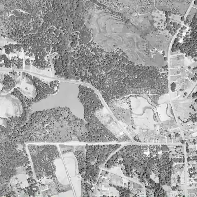
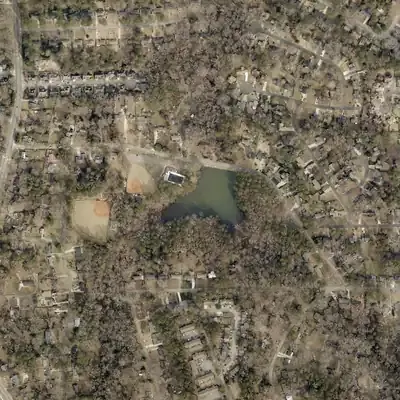
Lake Cofer sat drained in 1981 aerial photos, with no open water and a grassy bed, yet it was full in 1972 and again by 1993. The cause cannot be told from the images.
- First seen
- Already a full lake in the 1955 aerial photo, with a road running along its north shore, before the ballfields and subdivisions.
- Dam in the lidar
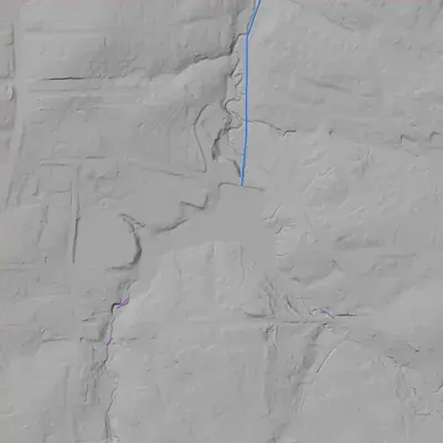
- The road along the north shore, North Park Drive, is the dam. Its flat crest is about 1,049.5 feet, roughly 4 feet above the lake. It stands about 14 to 18 feet above the stream just downstream, and is about 40 feet wide. No breach or open spillway shows. The outlet is probably a culvert or pipe that cannot be seen.
Low water and drawdowns
- Between 1972 and 1993; seen in 1981: The 1981 photo shows no open water. A pale bare rim, a dark vegetated flat in the northeast and grass or mud in the west arm fill the same basin that was full in 1972 and 1993. The cause is unknown: a planned drawdown, an outlet failure or a repair. One winter photo cannot show how long it stayed empty.
Read from aerial photos taken between 1940 and 2026 and from DeKalb County 2024 lidar, then checked by a second reading. How the photos were read.
History
Lake Cofer sits in Kelley Cofer Park in Tucker, DeKalb County. The City of Tucker's June 2020 article on its park dams says that the dam at the lake's north end is the elevated North Park Drive, so drivers cross it without noticing. The City counts four dams in its parks and calls Lake Erin its only Category One dam, which implies Cofer's dam is not in that class. The article gives no construction date, builder, height or stream. The public record reached so far does not say who built the lake or when, or where the park's name comes from. 1
Who built it
Not documented in any source reached. The only sourced fact about the structure is that the dam at the lake's north end is the elevated North Park Drive. The impounded stream, the builder and the purpose are unknown, and nothing sourced says whether the lake predates the park. 1
Timeline
- June 2020City of Tucker publishes 'Tucker's Lakes Held in Check By Dams', which describes the dam at Kelley Cofer Park's lake as the elevated North Park Drive at the lake's north end. 1
Names
The dam
The City of Tucker's June 2020 article says the dam at the lake's north end is the elevated North Park Drive, so the dam and the road embankment are the same structure. OpenStreetMap's mapped geometry is consistent with this: the lake's northern shore lies along the road. Height, length, spillway type, hazard class, rebuilds and contract numbers were not found. No NID ID was located, but the NID could not be queried (token required), so whether the dam is listed is unverified. The article's description of Lake Erin as Tucker's only Category One dam implies Cofer is not Category One; it does not state Cofer's class. 123
Visiting
Getting there
Kelley Cofer Park is a City of Tucker park; the City has a park page dated March 2025 (tuckerga.gov/venue/kelley-cofer-park/), though its content could not be read for hours, amenities or fishing and boating rules, so those are unconfirmed. North Park Drive, which forms the dam, is a road that the City article says drivers cross, so the lake's north side is visible from it.
What you can see
The lake and the raised roadbed of North Park Drive along its north end, which acts as the dam. No spillway, marker or ruin was documented in the sources reached.
Look, don’t dig. Parks, cemeteries and preserves are off limits to digging and collecting, and private land needs the owner’s permission to enter.
Open questions
- Who built the lake or its embankment, and when? It could predate or postdate the park.
- What stream does it impound, and what is the drainage area?
- Does the dam have a Georgia EPD Safe Dams permit or an NID record, and what is its hazard class?
- Who was Kelley Cofer, and when was the park named for them?
- Was North Park Drive built as the dam, or was an existing road later raised or widened?
- Which land lot and which pre-1860 owners or roads covered this site?
Know something? Write to hello@historyunderfoot.org. Family papers, photos and deeds often settle these.
Where to look next
- UGA 1938-40 DeKalb County aerial photography (Digital Library of Georgia / UGA Libraries map collection) to see whether the valley was already impounded or was farmland (UGA Libraries Map and Government Information Library, historic aerials)
- Historic USGS topographic quadrangles (Stone Mountain or Tucker area editions) to date the first appearance of the lake and North Park Drive (USGS Historical Topographic Map Collection (TopoView))
- Park dedication and naming: Tucker or DeKalb County commission minutes and news coverage of Kelley Cofer Park (City of Tucker records, DeKalb History Center, Georgia Historic Newspapers)
- Georgia EPD Safe Dams Program permit and inspection file, if the dam is regulated (Georgia EPD Safe Dams Program)
- National Inventory of Dams search by name and location to confirm whether any record exists (US Army Corps of Engineers NID)
- City of Tucker parks and public works staff for dam inspection reports and construction history (City of Tucker Parks & Recreation)
Sources
- Tucker's Lakes Held in Check By Dams (In Tucker, June 2020) City of Tucker
- OpenStreetMap way 34473734: Cofer Lake (geometry retrieved via Nominatim lookup) OpenStreetMap contributors
- OpenStreetMap way 9188894: North Park Drive, Tucker (geometry retrieved via Nominatim search) OpenStreetMap contributors