Still here · DeKalb County · Dam inventory GA01802
Lake Ivanhoe
A private 11-acre lake on Lucky Shoals Creek near Tucker, already on the 1956 USGS map and now run by the Lake Ivanhoe Community Club, founded 1962.
Watermark
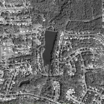
Lake Ivanhoe, at full length in 1981
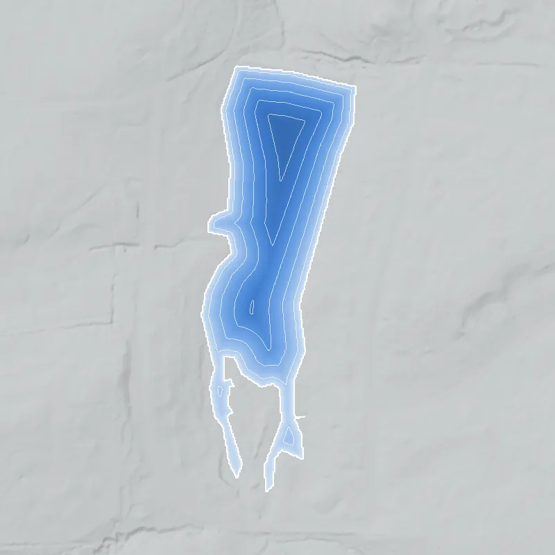
In 1981 Lake Ivanhoe was a long, dark, open pool of about 8 acres behind its 14-foot-tall earthen dam. Its open water ran south to the road, about 200 feet farther than today.
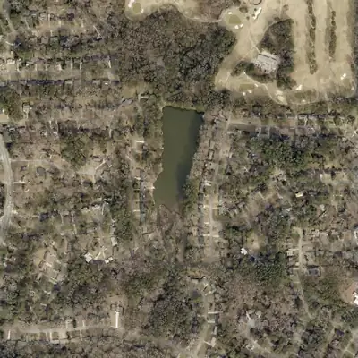
Today: The main lake still holds full water. The creek inlet at the south end has silted into a wooded delta, so open water now stops well short of the old southern tip.
- Area
- 7.9 acres
- Method
- Traced from photos
- Checked against
- 1981 aerial
The lake was filled in or built over, so its shoreline was traced from the 1981 aerial photo. The 1955 photo may show an even longer tail, but it could be silt flat. The old lakebed is buried by sediment, so depths are not measured. The trace is by eye. How Watermarks work.
From the air
Lake Ivanhoe was built between 1940 and 1955, and Lucky Shoals Creek has been filling its south end with silt ever since. The open water there shrank by roughly 130 to 200 feet in the 1980s and early 1990s.
- First seen
- Not in the 1940 aerial, which shows a creek meadow in farmland. Fully formed by 1955, with a dirt road on the dam.
- Dam in the lidar
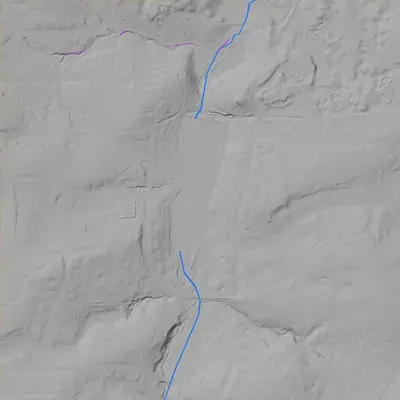
- An earthen dam at the north end, about 14 to 15 feet high at its tallest and roughly 400 feet long between the hillsides. The crest is level, about 1.4 to 1.8 feet above the pool in the middle and lower at both ends. No breach and no spillway channel is visible.
Read from aerial photos taken between 1940 and 2026 and from DeKalb County 2024 lidar, then checked by a second reading. How the photos were read.
History
Lake Ivanhoe is an impoundment of Lucky Shoals Creek in DeKalb County, owned by the Lake Ivanhoe Community Club, a neighborhood group for the Lake Ivanhoe Subdivision. NID lists an earthen dam 14 feet high and 360 feet long, about 11 acres, and a completion year of 1950. The lake appears on the USGS map made from 1955 aerial photos, before the club was founded in 1962. Today it is members-only. The club reports sediment building up at the creek inlet, a siphon repair in December 2022, and a dredging fund drive begun in 2023. 12345
Who built it
The builder and purpose are not documented in anything found. The lake is drawn on the USGS Stone Mountain quadrangle (aerial photos 1955, field check 1956), so it existed before the 1962 founding of the community club, which its site says was established by the subdivision's developer. That fits the NID's 1950 completion year, though NID years are often estimates. Whether the lake was a farm pond, a fishing lake or an early amenity is unknown. 135
Timeline
- 1950 (NID field)NID lists 1950 as the completion year and a 'Recreation' purpose. NID years are often estimates. The 1955-56 USGS map is consistent with it but does not confirm the year. Uncertain 15
- 1955-1956USGS Stone Mountain 1:24,000 quadrangle (aerial photos 1955, field check 1956) shows a long, narrow unnamed lake, labeled 1008 ft, in Land Lot 260, with few buildings nearby. 5
- 1962Lake Ivanhoe Community Club, Inc. founded. Its site says the developer of the Lake Ivanhoe Subdivision established it, and that the club maintains the lake, dam and greenspace. 23
- December 2022Lake lowered for siphon repair. The club's photo captions show sediment in the west channel and around the peninsula at the south end. 4
- 2023Club starts a 'Pledge to Dredge' campaign to dredge the south end to 4 feet and clean the creek, seeking at least $125,000 by 2027. 4
- March 2025Club photographs sediment and overgrowth at the creek inlet before culvert work. A dredging scope with a reduced peninsula footprint is proposed. 4
The dam
NID: earthen dam, 14 ft high (11 ft hydraulic height), 360 ft long; about 11 surface acres, 53 acre-ft normal and 62 acre-ft maximum storage; uncontrolled spillway; designer unknown; hazard Low; condition Not Rated; not state-regulated; emergency action plan not required; record last updated 04/20/2021. The club owns the lake, dam and spillway. Its projects page says the dam and east spillway need repair, with a second siphon and replacement of washed-out rip-rap under consideration, and that the lake was lowered in December 2022 for a siphon repair. 134
- Year in the inventory
- 1950
- Dam height
- 14 ft
- Surface
- 11 acres
- Average depth
- about 4.8 ft
- Stream
- Lucky Shoals Creek
- Owner type
- Private
Figures from the U.S. Army Corps of Engineers’ National Inventory of Dams. Its “year” is often a rebuild or survey date, and average depth is storage divided by area.
Around the lake
Water
Per the club, Lucky Shoals Creek flows north from Kelly Cofer Lake, under Rotherwood Drive, into Lake Ivanhoe, then on to the lake at Heritage Golf Course, Jackson Creek and the Yellow River. Heavy rain washes litter and sediment down the creek into the lake.
Visiting
Getting there
Private and members-only. Club rules limit the lake to active members and lakefront owners, and say the greenspace is not open to the public and the dam is off-limits. Fishing is catch-and-release, and boats must be non-motorized or battery-powered. No water activities after dark.
What you can see
No public access is documented. The club posts 'Private Lake' and 'Member Access Only' signs and proposes fencing at the dam. The club's property runs to Webb Road at the dam and to Rotherwood Drive at the south end, but whether the lake can be seen from those public roads was not confirmed.
Look, don’t dig. Parks, cemeteries and preserves are off limits to digging and collecting, and private land needs the owner’s permission to enter.
Open questions
- Who built the dam around 1950, and for what purpose (farm pond, fishing lake or subdivision amenity)?
- When was the Lake Ivanhoe Subdivision platted, and who was the developer? The 1962 charter and 1967 bylaws are on the club's site but cannot be downloaded.
- Was the lake called Ivanhoe before the subdivision, or named for it?
- Why is the dam not state-regulated in NID, and what is its actual condition? The club says the dam and east spillway need repair.
- Has the dredging or dam repair gone ahead since March 2025?
Know something? Write to hello@historyunderfoot.org. Family papers, photos and deeds often settle these.
Where to look next
- 1962 original charter and 1967 original bylaws, listed in the club's governing-documents folder (file downloads are disabled by the owner) (Lake Ivanhoe Community Club website, Rules and Regulations page; ask the club)
- Later USGS topo editions (1968-1997 Stone Mountain quads) to track shoreline and sediment (USGS topoView / National Map historical topo maps)
- UGA 1938-40 DeKalb aerials to test whether the valley was open before the lake (UGA Libraries Map and Government Information Library)
- Subdivision plat and dam easement records for Land Lot 260, 18th District (DeKalb County Clerk of Superior Court, plat and deed records)
- Newspaper mentions of the lake (developer ads, dredging, dam repair). A Georgia Historic Newspapers search for 'Lake Ivanhoe' Tucker returned 2014 and 2019 Champion Newspaper (Decatur) issues, not yet read (Georgia Historic Newspapers, Digital Library of Georgia)
Sources
- National Inventory of Dams, record GA01802 (Lake Ivanhoe Dam), nationwide CSV, data updated 2026-9-23 U.S. Army Corps of Engineers, National Inventory of Dams
- Lake Ivanhoe Community Club (home page) Lake Ivanhoe Community Club, Inc.
- Lake Ivanhoe Community Club: About Us (membership, community property, Constellations of Care) Lake Ivanhoe Community Club, Inc.
- Lake Ivanhoe Community Club: Projects (dredging, dam remediation, watershed) Lake Ivanhoe Community Club, Inc.
- USGS 1:24,000 Stone Mountain, GA quadrangle, 1956 edition (aerial photos 1955, field check 1956) U.S. Geological Survey, Historical Topographic Map Collection