Filled in · Location approximate
Mooney's Lake
A 1920 summer swimming and canoeing resort off Piedmont Road in Lindbergh, drained and filled in 1957-58 for a shopping center, now near the I-85/GA 400 interchange.
Watermark
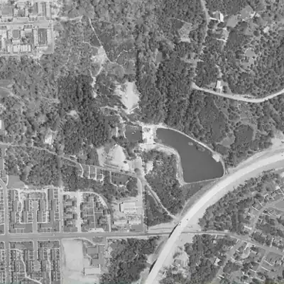
Mooney's Lake, full in 1955
A bean-shaped lake about 215 m long and nearly 5 acres, held by an earthen rim, with two tiny islets, a sandy east shore and a small pool at its west end. Full in 1949 and 1955; gone by 1968.
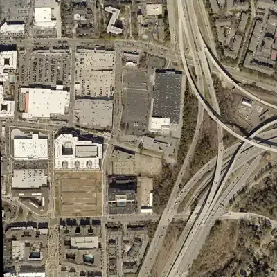
Today: The old basin is a flat graded area with no trace of the lake. The GA 400 and I-85 ramps cover its east side, and a big-box store lot sits at its north edge.
- Area
- 4.8 acres
- Method
- Traced from photos
- Checked against
- 1955 aerial
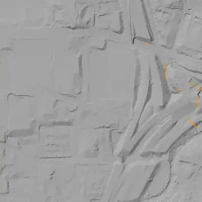
The lake was filled in or built over, so its shoreline was traced from the 1955 aerial photo. Traced from a 1955 aerial, then shifted to today's map; position is good to about 30-50 px. No depth known, no dam remains in the lidar, and the drainage date falls between 1955 and 1968. How Watermarks work.
From the air
Mooney's Lake was drained sometime between 1955 and 1968. Lindbergh Plaza was built beside it, not on it, and GA 400 ramps later covered its east shore.
- First seen
- A full, bean-shaped lake shows in the 1949 aerial photo; the 1940 photo shows only bare, dry ground on the spot.
- Gone
- The lake is gone by 1968; it was last seen full in 1955, and no photos fall in between.
- Dam in the lidar
- A curved earthen rim with a straight, dam-like south edge shows around the east and south shores in 1949 and 1955, so the lake was embanked. No separate earthwork survives in the lidar. It is now under or beside the GA 400 and I-85 ramps.
Low water and drawdowns
- Between 1955 and 1968 possibly: Full in 1955, with no open water by 1968. This was a permanent draining, not a drawdown. The date cannot be narrowed; 1957-58 fits but is unconfirmed.
- 1940 (uncertain) possibly: Bare, water-free ground with a channel lies where the 1949 lake sits. It could be a drained lakebed, or the valley before any lake was built.
Read from aerial photos taken between 1940 and 2026 and from USGS 3DEP lidar, then checked by a second reading. How the photos were read.
History
Deuward S. Mooney developed a recreation center in 1920 in what AJC describes as country then, near Piedmont Road in Lindbergh. It had two spring-water pools, a lake for swimming and canoeing, horseback riding, miniature golf, a zip line over the water, a children's train and a pavilion. Coasterpedia, citing Atlanta Constitution clippings, says arson destroyed the bathhouses in February 1957; AJC and Wikipedia say the pavilion burned. The lake was drained and filled in 1958 for the Broadview Shopping Center, later Lindbergh Plaza. AJC places the site at today's I-85/GA 400 interchange area. Sources differ on the closing year (1957 or 1958). 12345
Who built it
Deuward S. Mooney developed the site into a recreation center in 1920, per Wikipedia, AJC and Coasterpedia; the other AJC piece says he turned the lake into a summertime escape in the 1920s. Its purpose was leisure: swimming, canoeing, a pavilion and later amusements. The sources I could open do not say which stream fed or was dammed to make the lake, who built the impoundment, or how large it was. AJC and Wikipedia mention two spring-water pools, which suggests spring supply, but that is not stated for the lake itself. 4231
Timeline
- 1920Deuward S. Mooney develops the site into a recreation center with spring-water pools, a swimming and canoeing lake, horseback riding, miniature golf and a railroad; AJC adds a zip line over the water and a children's train. 4231
- 1919-1944 (newspaper hits)Georgia Historic Newspapers returns 54 hits for 'Mooney's Lake', 25 of them dated 1919-1944, including The Southern Israelite (June 30, 1934). Article text was not read, so whether they concern this lake is unconfirmed. Uncertain 6
- 1950sAn Allan Herschell 'Little Dipper' kiddie roller coaster opens and closes at the park within the decade, the only coaster Coasterpedia documents there. 1
- February 1957Coasterpedia says the park's bathhouses were destroyed by arson. Its references include Atlanta Constitution items titled 'Spectacular Fire' and 'Youth Tells Car Thefts, Burglaries'; the clippings could not be opened here. Likely 1
- 1950s (year unclear)AJC and Wikipedia say the pavilion burned in the 1950s, after which the venue closed. AJC ties the 1958 closing to a fire damaging the pavilion area. Likely 234
- 1958The park closes and the lake is drained and filled with dirt. AJC gives 1958 as the end of the 1920-58 operating span; Coasterpedia gives 1957 as the closing year. 35241
- 1958Per Wikipedia, developers Jordan, Davis and Carter build the Broadview Shopping Center on the drained lake, later called Lindbergh Plaza. AJC confirms a Broadview Plaza was built on the land but does not name the developers. Likely 42
- 1959Lenox Square opens and, per AJC, 'eclipsed everything else', dimming the older Piedmont Road commercial area. 2
- 1963Per Wikipedia, Broadview, later renamed Lindbergh Plaza, has about 30 retail stores, including a two-level K-Mart. Likely 4
- 1970sThe Great Southeast Music Hall operates in the Broadview/Lindbergh Plaza shopping center. Wikipedia lists Billy Joel, B.B. King and the Sex Pistols among its acts. Likely 42
- August 1, 1993The GA 400 Buckhead extension opens to traffic after three years of construction, ending at I-85 near the area AJC says the lake once occupied. 73
- April 2, 2014New ramps connecting GA 400 south to I-85 north and I-85 south to GA 400 north open, ending the need to use Sidney Marcus Boulevard. 7
Names
The dam
No dam record found. It is not in the National Inventory of Dams (nid is null), and none of the sources describe an embankment, spillway, height or engineering. The lake was drained and filled in 1958, so no dam is known to survive. Whether it was an on-stream impoundment or a spring-fed basin is unresolved.
Around the lake
Water
No stream or watershed is named in the sources. AJC and Wikipedia mention two spring-water pools on the property.
Segregation
No sourced information. As a private commercial resort operating 1920-1958 in Georgia, its admission policy is unstated in the sources I could open. This is a question for newspaper ads and oral histories, not an assumption.
Before 1861
AJC says that when the lake operated, parts of Piedmont Road were unpaved and Buckhead was considered 'in the country'. No pre-1860 land lot, mill or road connection was found.
Visiting
Getting there
Nothing of the lake remains. It was filled in 1958 and the site is now occupied by the I-85/GA 400 interchange and Lindbergh Plaza (AJC). Piedmont Road, Sidney Marcus Boulevard and the interchange are busy commuter roads and commercial property, not a park.
What you can see
No dam, spillway, ruins or historical marker was found in the sources opened; the earlier research pass reported no Historical Marker Database entry, which was not re-verified. A visitor sees the I-85/GA 400 interchange, Piedmont Road and the Lindbergh Plaza area.
Look, don’t dig. Parks, cemeteries and preserves are off limits to digging and collecting, and private land needs the owner’s permission to enter.
Open questions
- Exact footprint: Wikipedia says east of Piedmont Road off Morosgo Drive; AJC says the site is now the I-85/GA 400 interchange area beside Lindbergh Plaza. These look compatible but no source maps the shoreline.
- Which stream or spring fed the lake, and was there a dam?
- Closing year: 1957 (Coasterpedia) or 1958 (both AJC pieces, Wikipedia)?
- Which building burned: bathhouses (Coasterpedia, Feb 1957) or the pavilion (AJC, Wikipedia)? Possibly both.
- Admission policy and whether it was whites-only during segregation.
- Do the Georgia Historic Newspapers hits from the 1920s-30s refer to this Atlanta lake?
- Did Mooney own the land, or lease it, and when did the land pass to Jordan, Davis and Carter?
Know something? Write to hello@historyunderfoot.org. Family papers, photos and deeds often settle these.
Where to look next
- Georgia Historic Newspapers search results for 'Mooney's Lake' (54 hits, dates in the index run from 1893 to 2048, which includes OCR errors). Examples: Southern Israelite 1934, News and Banner (Franklin) 1953, Forest Park News 1956, Summerville News 1967. Read the articles to confirm which lake and find ads, prices and rules. (Georgia Historic Newspapers (Digital Library of Georgia))
- Atlanta Constitution clippings cited by Coasterpedia: 'Spectacular Fire' and 'Youth Tells Car Thefts, Burglaries' (the February 1957 arson). Fetching returned 403 here. (Newspapers.com clippings)
- AJC 'Before and after: Mooney's Lake in Buckhead' photo comparison, which says the lake operated 1920-58 off Morosgo Drive. (Atlanta Journal-Constitution)
- 1949 Georgia State University Atlanta aerial photography, which should show the lake and pools before the 1958 fill. (Georgia State University Library aerial collection)
- USGS 1:24,000 Northeast Atlanta topographic map editions from the 1950s to compare with the 1960s edition showing the shopping center. (USGS Historical Topographic Map Explorer)
- Fulton County deed and plat records for the Broadview Shopping Center tract, Jordan, Davis and Carter, 1958. (Fulton County Superior Court Clerk real estate records)
- Search Atlanta History Center photo collections and oral histories for 'Mooney's Lake' and 'Mooney's Pool'. The search interface needs JavaScript and could not be read here. (Atlanta History Center album)
Sources
- Mooney's Lake Coasterpedia
- Actual Factual Georgia (Mooney's Lake) Atlanta Journal-Constitution
- Exploring Atlanta's lost amusement parks Atlanta Journal-Constitution
- Lindbergh, Atlanta Wikipedia
- Before and after: Mooney's Lake in Buckhead Atlanta Journal-Constitution
- Georgia Historic Newspapers search results for 'Mooney's Lake' Digital Library of Georgia
- Georgia State Route 400 Wikipedia