Still here · DeKalb County · Dam inventory GA01326
Murphey Candler Lake
Brookhaven's park lake was dammed in 1953-54 (one source says 1960), then repaired, dredged and drained several times, most recently in 2025-26.
Watermark
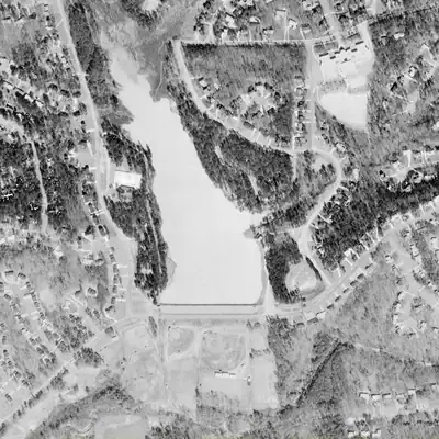
Murphey Candler Lake, longest in 1972
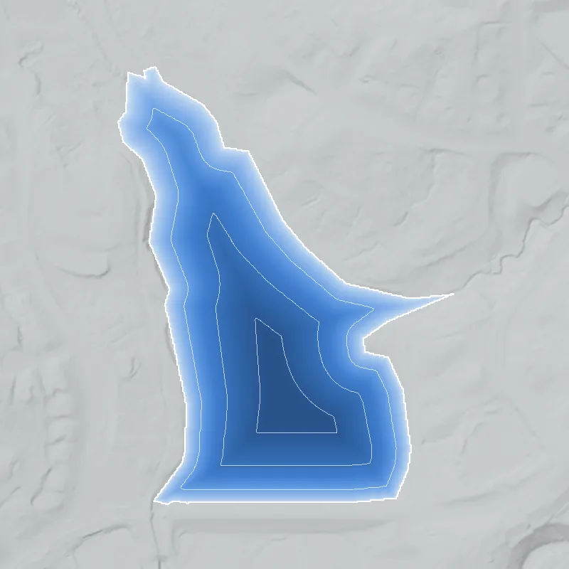
In 1972 the park lake reached about 28 acres, roughly 130 yards farther up the North Fork of Nancy Creek than today. Its north end faded into marsh. Creek silt filled that upper arm by 1981.
Today: Today the open water ends farther south, at the silted arm's edge, and covers about 22 acres. The lake was drained in 2025 for dam work and dredging, then refilled.
- Area
- 27.9 acres
- Method
- Traced from photos
- Checked against
- 1972 aerial
The lake was filled in or built over, so its shoreline was traced from the 1972 aerial photo. The north tip is blurry in 1972 and may include wet marsh. Old water depth is unknown because today's lidar is flat over the lake. Refill dates in city records are unconfirmed. How Watermarks work.
From the air
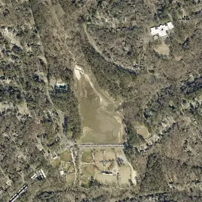
Murphey Candler Lake once ran 230 to 620 feet farther up the creek valley. Silt filled that arm by 1981, and the 2026 aerial shows the whole lake almost drained.
- First seen
- Not in the 1940 aerial, which shows farm strips and forest. The dam and a smaller pool are in place by 1955.
- Dam in the lidar
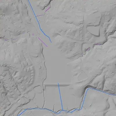
- A straight earthen dam crosses the south end and carries the road and path. It is about 20 feet tall at most and roughly 800 to 930 feet long. The crest is nearly level at about 893 feet. A spillway notch at the west end sits about 7 feet below the crest. No breach was found.
Low water and drawdowns
- Between early 2025 and early 2026: An early-2025 winter aerial shows a full lake. The 2026 winter aerial shows almost the whole bed exposed, with a winding creek channel, a few small pools and sand deltas at the north end. City records say draining began in late June 2025.
- 1955 (uncertain) possibly: The pool is smaller than today's, with bare pale banks. It may be a new lake still filling, not a drawdown. Low confidence.
- About 2001 (not established) possibly: Pale and tan banks might be exposed silt, but they could be shallow plants or the park trail. The shorter pool is mostly silting. Low confidence.
Read from aerial photos taken between 1940 and 2026 and from DeKalb County 2024 lidar, then checked by a second reading. How the photos were read.
History
Murphey Candler Lake sits on the North Fork of Nancy Creek, just south of I-285 in Brookhaven, where an unnamed stream joins it. The city's 2016 report dates the earthen dam to 1953; other sources say 1954 or 1960. DeKalb County acquired the park land in 1952 from Fred Wilson and the Long family. The report's timeline lists a reported 1957 failure, overtopping in 1973, repairs in 1974, and a 2002 spillway rebuild that lowered the lake 1.5 feet. Dredging followed in 2020. In 2025 the city drained the lake to rehabilitate a corroded low-water drain and dredge near the dam; refilling was under way in early 2026. 123456789
Who built it
The Conservancy and Wikipedia say the park was planned in 1950 with prospective donations of about 100 acres from Fred Wilson and 35 acres from M. A. Long and his wife, and that DeKalb County acquired the 135 acres in 1952. Past Tense GA credits a Kiwanis Club of North DeKalb campaign and says 165 acres were donated in 1953; the figures conflict. Groundbreaking was January 31, 1954. The city's watershed report dates the lake to 1953, a 2015 Rough Draft article to 1954, and a 2025 Rough Draft article to 1960. The lake sits where the North Fork and an unnamed stream meet. No source found says who engineered or built the dam. 451012113
Timeline
- Mid-19th centuryPast Tense GA says the land was likely Salathiel Adams's, and that a historic cemetery for Adams and his family lies along Oconee Pass in the park. Blog source only. Likely 10
- 1950Park first planned, with prospective donations of about 100 acres from Fred Wilson and 35 acres from M. A. Long and his wife. The North DeKalb Planning Council championed it. 45
- 1952DeKalb County acquires the 135 acres between Ashford Dunwoody Road and Chamblee Dunwoody Road, per the Conservancy and Wikipedia. Past Tense GA gives 165 acres donated in 1953 instead. 4510
- 1953Past Tense GA credits a Kiwanis Club of North DeKalb campaign and deeds signed at the Long home. The city's 2016 watershed report dates construction of the lake and dam to 1953. Likely 101
- January 31, 1954Groundbreaking ceremony for the park. A 2015 Rough Draft article says the lake was created in 1954. 452
- 1957Past Tense GA says 'North Atlanta' approved $1 million in bond funds for the park in 1957. Purpose and details are not explained. Uncertain 10
- 1957The city's 2016 timeline says the dam 'reportedly failed' with a 15-foot opening. It gives no source or details. Uncertain 1
- 1958Past Tense GA says the first baseball teams, called Brookhaven Little League, began at the park. Likely 10
- 1973-1974City timeline: dam overtopped in 1973, then repaired in 1974 to fix overtopping and seepage. Wikipedia describes an early-1970s flash flood and says the county made the new Perimeter Mall redirect its runoff. 15
- 1978Georgia Rules for Dam Safety adopted. The oldest known dam record is a 1978 inspection; a U.S. Army Corps of Engineers report gives lake area as 25.3 acres at 885.5 ft msl. 1
- 1982City timeline says the lake was 'reportedly dredged'; no volume reported. Uncertain 1
- 1998Wikipedia says silt buildup forced a drawdown and a 1998 dredging using a U.S. DOT grant; a 2025 Rough Draft article also says the lake was drained and maintained in 1998 and 2013. The city plan does not list 1998. Likely 531
- 1999A sediment study estimates 110,900 cubic yards of sediment could be removed from the lake. 1
- 2002Spillway modifications built and 57,000 cubic yards of sediment removed. Lake level lowered 1.5 ft to 884 ft msl to meet dam-safety rule changes. 1
- April 2015Brookhaven council unanimously approves a $203,315.47 contract with Sustainable Water Planning and Engineering LLC for a lake and watershed study. 2
- October 16, 2015Rough Draft reports the dam is high-hazard and now owned by Brookhaven, not DeKalb County. Its 2012 inspection, filed under DeKalb, found 'relatively minor maintenance issues'. 11
- August 2016Nancy Creek Watershed Improvement Plan and its Murphey Candler State of the Lake report are published. The lake rates 'eutrophic', with 20 acres of lake in a 135-acre park. 1
- January 15 to April 17, 2020Merrell Bros. dredges nearly 14,000 cubic yards from the north end near I-285 for a final $1,647,001 (budget $1,795,828). A separate shoreline restoration cost $181,591. 1487
- July 2022Work starts on replacing the 5-ft sidewalk on the dam with an 11-ft multi-use path and seven observation decks; contract approved June 14, 2022. Completion date not confirmed. 15
- Late June to September 2025Lake dewatered; cofferdam built; corroded 30-inch low-water drain rehabilitated with a riser and cured-in-place pipe lining. Construction began July 23, 2025; fish relocated. 913
- October 9, 2025Brookhaven council approves $1.5 million for North Georgia Concrete to dredge near the dam and low-water drain (about 10,000 cubic yards per Rough Draft), planned through January 2026. Completion not confirmed. 31617
- February 12, 2026City project page (updated that day) shows controlled refilling in process over about twelve weeks under Safe Dams rules, estimated done April 30, 2026; Georgia DNR to help restock fish. 9
- March 10, 2026Council approves a $150,000 piggyback contract with Clean Water Consultants to repair two undermined woody-material stream structures, under a corrective action plan to the Army Corps of Engineers. Likely 18
Names
- Candler Lake
- Past Tense GA says the lake was first named Candler Lake, when the park was named to honor Scott Candler Sr. and his father, Charles Murphey Candler. Blog-level source; not corroborated elsewhere. 10
- Murphey Candler Lake Dam
- Official National Inventory of Dams name (NID ID GA01326); the NID record lists no other or former names. 6
- Lake Murphey Candler / MCP Lake
- Variants used on City of Brookhaven project pages, for example the 'MCP Lake Low Water Drain Rehabilitation' page. 9
The dam
Earthen dam on the North Fork of Nancy Creek. NID: 19 ft high, about 870 ft long, 276 acre-ft normal and 547 acre-ft maximum storage, owner type Local Government, hazard High, condition Satisfactory, no completion year. The city's page says it is a Category 1 dam under Georgia's Safe Dams Act (EPD permit needed for significant work) and must be inspected quarterly by a qualified engineer-of-record. The 2016 report says the lake level was lowered from 885.5 ft (1978) to 884 ft msl in 2002 to meet dam-safety rule changes. A corroded 30-inch metal low-water drain pipe under W. Nancy Creek Drive was rehabilitated in 2025 with a riser and cured-in-place pipe lining (bid 24-022). 6121913
- Dam height
- 19 ft
- Surface
- 36 acres
- Average depth
- about 7.7 ft
- Stream
- N. Fork Nancy Creek
- Owner type
- Local Government
Figures from the U.S. Army Corps of Engineers’ National Inventory of Dams. Its “year” is often a rebuild or survey date, and average depth is storage divided by area.
Around the lake
Water
The lake impounds the North Fork of Nancy Creek plus an unnamed stream; the 2016 report gives a 1,320-acre watershed and says runoff from neighboring jurisdictions and I-285 drains into it. The city says sediment is deepest at the north end (0.25 to 5 ft). The plan proposes four GDOT-owned floating trash racks on I-285 drainage, at $50,000 each in planning-level capital cost.
Civil War
On July 17, 1864, McPherson's Army of the Tennessee marched down what is now Chamblee Dunwoody Road (the park lies between it and Ashford Dunwoody Road) and some troops camped near Nancy Creek. On July 18, columns of the 16th and 23rd Corps briefly met at Old Cross Keys, about 2 km south. No source places camps or works on the lake site.
Segregation
No source found ties the lake or park to segregation, and pool or park access rules for the 1950s-60s are undocumented.
Before 1861
Old Cross Keys, an antebellum crossroads settlement and post office with James Reeve (1792-1852) as postmaster and merchant, lies about 2 km south at Johnson Ferry and Ashford Dunwoody roads. Past Tense GA says the park land was likely Salathiel Adams's in the mid-1800s.
Visiting
Getting there
Public park run by the City of Brookhaven on W. Nancy Creek Drive. Wikipedia lists a pool, a 2-mile nature trail, picnic pavilions and youth sports fields. The Murphey Candler Park Conservancy, established 2012, supports it. The lake was drained from mid-2025; the city's page, updated February 12, 2026, showed refilling in process with completion estimated April 30, 2026. Current water level and fishing rules were not confirmed.
What you can see
The earthen dam and the path across it on the north side of W. Nancy Creek Drive (planned with seven observation decks), the spillway that flows under the road, and the lake with its park trail. Check current lake conditions first, since refilling and fish restocking were still under way in early 2026. No historical marker about the lake's origins was found.
Look, don’t dig. Parks, cemeteries and preserves are off limits to digging and collecting, and private land needs the owner’s permission to enter.
Open questions
- Which year was the dam really finished: 1953, 1954 or 1960? Sources disagree.
- Who designed and built the dam, and what did it cost?
- Did the reported 1957 failure and 15-foot opening really happen, and what does it correspond to in county records?
- Was the lake dredged in 1982, 1998, 2002 or 2013? Rough Draft 2025 says 1998 and 2013; the 2016 plan says 1982 and 2002.
- Did the park land total 135 acres (Conservancy, Wikipedia, city report) or 165 acres (Past Tense GA)?
- Were the park, pool and lake open to Black residents in the 1950s-60s?
- The lake area is 36 acres (NID) versus 20 acres (2016 report); NID drainage area of 1065 has unclear units against 1,320 acres.
- What was the 1957 'North Atlanta' bond approval for?
- Did the 2025-26 dredging and refill finish on schedule, and is the lake now at full pool?
Know something? Write to hello@historyunderfoot.org. Family papers, photos and deeds often settle these.
Where to look next
- UGA 1938-40 DeKalb County aerials, likely to show the Nancy Creek valley before the lake was built (not checked). (UGA Libraries Map and Government Information Library / Digital Library of Georgia)
- USGS Chamblee 7.5-minute topographic map editions from the 1950s to the 1970s would show the lake outline, roads and Perimeter development over time. (USGS topoView (historical topographic map collection))
- 1978 U.S. Army Corps of Engineers dam inspection report, cited in the watershed plan with 25.3 acres at 885.5 ft msl; also 2002 spillway modification plans and 1974 repair records. (Georgia EPD Safe Dams Program open records file for the dam)
- DeKalb County Board of Commissioners minutes and deed records for 1952-54 donations by Wilson and the Longs, plus 1957 bond and dam-failure records. (DeKalb County Clerk / DeKalb History Center archives)
- Award and agenda items for bid 24-022 (low water drain) and the October 9, 2025 dredging vote, with any dam engineering reports and the 2025-2026 quarterly inspection reports the city page lists. (City of Brookhaven Legistar and Public Works)
- Newspaper coverage of the park's 1950s founding; a search of Georgia Historic Newspapers for 'Murphey Candler' is a starting point (results not re-verified in this check). (Georgia Historic Newspapers (Digital Library of Georgia))
Sources
- City of Brookhaven Nancy Creek Watershed Improvement Plan, Appendix A: Murphey Candler State of the Lake Report (August 2016) City of Brookhaven
- Study will examine Murphey Candler Lake, Nancy Creek watershed (Apr 17, 2015) Rough Draft Atlanta (Reporter Newspapers)
- Brookhaven approves $1.5M for Murphey Candler Lake dredging (Oct 16, 2025) Rough Draft Atlanta
- About the Park Murphey Candler Park Conservancy
- Murphey Candler Park Wikipedia
- National Inventory of Dams record GA01326 Murphey Candler Lake Dam (extract in project file vec/nid_inside.json) U.S. Army Corps of Engineers
- Murphey Candler Lake Dredging (2020 project page) City of Brookhaven
- Brookhaven parks improvements continue during pandemic (Apr 24, 2020) Rough Draft Atlanta
- MCP Lake Low Water Drain Rehabilitation City of Brookhaven
- Before Murphey Candler Park and Early Days Past Tense GA
- State monitors 'high-hazard' dams (Oct 16, 2015) Rough Draft Atlanta
- Murphey Candler Lake Dam Operation, Maintenance, and Permitting City of Brookhaven
- 24-022 Low Water Drain CIPP Rehabilitation Murphey Candler Lake Dam (bid listing) GovTribe (City of Brookhaven bid)
- Dredging of Brookhaven's Murphey Candler Lake begins (Jan 18, 2020) Rough Draft Atlanta
- Murphey Candler Park I Planning City of Brookhaven
- Murphey Candler Park lakebeds to be dredged, will cost $1.5 million (Oct 10, 2025) WSB-TV Channel 2
- Brookhaven City Council funds Murphey Candler Park dredging (Oct 13, 2025) Dredging Today
- Brookhaven council approves $150,000 contract for Murphy Candler Lake stream repairs (Mar 10, 2026) Citizen Portal