Still here · DeKalb County · Dam inventory GA02051
North Lake
Private 22-foot earthen dam and roughly 15-to-18-acre lake; Wikipedia says the Northlake area and its mall are named for it.
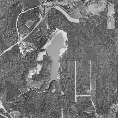
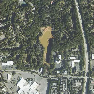
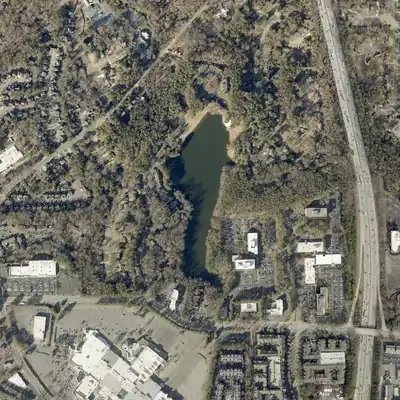
From the air
In October 2023, federal aerial photos caught North Lake drawn down, with a ring of bare mud and equipment tracks on the dam. No record of this was found.
- First seen
- The earliest usable aerial, from 1955, already shows a full lake behind a dam; bare banks suggest construction had just ended.
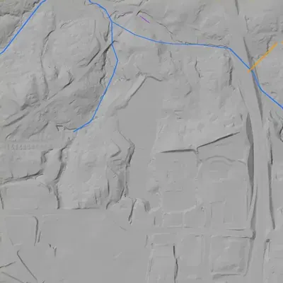
- Dam in the lidar
- An earthen dam on the north-northwest shore. It is about 26 feet tall at its highest, with the crest near 968 feet above sea level, and roughly 400 to 450 feet long. It is lower, 17 to 20 feet, at its ends. No breach. A concrete apron at the west end may be the spillway, but that is uncertain.
Low water and drawdowns
- October 2023: Federal aerial photos show the pool shrunk to the west-central and southern part. A ring of pale bare mud, roughly 65 to 165 feet wide, lay along the dam side, the north end and the northeast shore. Equipment tracks, disturbed soil on the dam face and a gray gravel area west of the dam suggest dam or spillway work. The drop was probably a few feet but could not be measured. The lake was full again in 2024, with a re-seeded dam slope.
Read from aerial photos taken between 1940 and 2026 and from DeKalb County 2024 lidar, then checked by a second reading. How the photos were read.
Depth
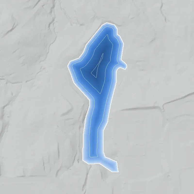
Modeled from the shoreline shape and the dam inventory’s average depth: deepest point about 16 ft. Treat it as an estimate; no survey of the lake bottom was found. How depth is estimated.
History
North Lake is a private lake of roughly 15 to 18 acres behind a 420-foot-long earthen dam, 22 feet high and rated high-hazard, in the Northlake area of DeKalb County. It is on the 1954 USGS map, and the federal dam inventory dates the dam to 1953. Wikipedia says the Northlake community and Northlake Mall are named for it. No builder, purpose, plat or repair record turned up. County tax records place the lake on a 33.85-acre parcel at 100 Northlake Parkway listed to Atlanta Northlake Co, while the dam inventories name Atlanta Community Services as owner. Public access is not documented. 123456
Who built it
The record does not say who built the dam or why. NID gives 1953 as the year completed (a figure that may be an estimate), lists the use as recreation, the owner type as private, the designer as unknown and the stream as 'Unknown'. The USGS Northeast Atlanta quad (topography from 1952 aerial photos, field checked 1954) shows the lake at 960 ft with a dam mark at its north end. Because the field check came after the photos, the map alone cannot show whether the lake existed in 1952. A 2014 realtor blog post says, in its own words, that a hunting lodge was built near the lake in the 1900s. No other source was found, so the claim is unverified and does not show that an earlier pond existed. 247
Timeline
- July 18, 1864Logan's XV Corps camps at Henderson's Mill, about 1.5 miles west of Browning's Court House, partly to get an adequate water supply. The mill stood about 300 ft northwest of marker 044-18, roughly 350 m north of today's dam. 910
- 1900sA 'hunting lodge' is said to have been built near the lake now known as North Lake. The only source is a realtor's blog sentence with no cited source of its own; not independently confirmed. Uncertain 7
- 1911Greenville Henderson's grist mill on Henderson Mill Road is demolished. The state marker says the flat land on both sides of the road was the mill pond area. 9
- 1952-1954USGS Northeast Atlanta quad (topography from 1952 aerial photos, field checked 1954) shows the lake at 960 ft with a dam mark at its north end, east of Henderson Mill Road. 4
- 1953National Inventory of Dams year completed for North Lake Dam. This figure is often an estimate and no construction record was found. Uncertain 2
- 1968 and 1973USGS purple revisions to the 1954 sheet, compiled from 1968 and 1973 aerial photos (not field checked), add urban-area tint, roads and buildings around the lake; the lake outline is unchanged. 4
- October 6, 1971Northlake Mall opens near the lake, according to Wikipedia. Wikipedia's Northlake page says the area and the mall are named after North Lake; no independent source was found. Likely 611
- 1991-1995USGS Northeast Atlanta quad (field checked 1991, imagery 1993, edited 1995) labels the water body 'North Lake' and the mall 'North Lake Mall'. 12
- March 16, 2017Most recent inspection date recorded in the National Inventory of Dams (data updated 2021): condition Satisfactory, emergency action plan prepared. No later inspection appears in NID. 2
- June 4, 2025Georgia EPD dam inventory lists North Lake Dam (DeKalb, Category I, 22 ft, 156 acre-ft) with the owner name 'Atlanta Community Services'. 1
Names
- North Lake Dam
- Name used for the structure in the Georgia EPD Safe Dams inventory (state ID 044-012-00171) and in the National Inventory of Dams. 12
- the Lake now known as north lake
- Phrase used in a 2014 realtor blog post about Northlake history. The post's own sentence, not attributed to the Tucker Historical Society, says a 'hunting lodge' was built near it in the 1900s. 7
The dam
State and federal inventories list an earthen dam 22 ft high and 420 ft long, with maximum storage of 156 acre-feet and an uncontrolled spillway. It is Georgia Safe Dams Category I (NID: high hazard, condition Satisfactory as of a March 16, 2017 inspection, emergency action plan prepared), state ID 044-012-00171. NID surface area is 18 acres; the 2023 USGS polygon measures about 0.061 sq km (roughly 15 acres). NID's drainage area of 272 square miles cannot be right for a pond this size and is probably a data error. No rebuild, drawdown, engineering study or contract was found. NID and EPD (June 2025) both list the owner as 'Atlanta Community Services'; EPD says its owner names come from county tax records and may be out of date. A firm of that name manages homeowner associations, but a link to this dam was not confirmed. The county tax layer lists Atlanta Northlake Co as owner of the lake parcel. 12358
- Year in the inventory
- 1953
- Dam height
- 22 ft
- Surface
- 18 acres
- Owner type
- Private
Figures from the U.S. Army Corps of Engineers’ National Inventory of Dams. Its “year” is often a rebuild or survey date, and average depth is storage divided by area.
Around the lake
Water
USGS 3DHP hydrography maps Henderson Mill Creek passing north of the lake, about 100 to 170 m from the lake polygon. No mapped channel runs through the lake. An unnamed channel west of the lake joins the creek about 300 m north of the dam. Following the flowlines downstream, the creek runs into North Fork Peachtree Creek, then Peachtree Creek and the Chattahoochee River. The lake's own outlet is not mapped; its dam is at the north end. NID lists the stream as 'Unknown'.
Civil War
Logan's XV Corps (Army of the Tennessee) camped at Henderson's Mill on the night of July 18, 1864, and resumed its march to Decatur the next day. The mill site is roughly 350 m north of the dam. No 1864 feature is documented on the lake itself.
Before 1861
Henderson's grist mill (Greenville Henderson, 1792-1869, and son Rufus, 1823-1872) stood beside Henderson Mill Road until it was demolished in 1911. The lake parcel is in Land Lot 209, 18th District, per the county parcel number. A 2014 local-history blog and a Tucker Historical Society piece describe the area before the mall as mostly pasture and trees. No pre-1860 mill, road or house was found on the lake site itself.
Visiting
Getting there
Private. County tax records list the 33.85-acre parcel at 100 Northlake Parkway (zoned R-100) to Atlanta Northlake Co, and both dam inventories name Atlanta Community Services as dam owner. No public park, trail, boat launch or public viewpoint was found. Anyone wanting a look should stay on public roads and not enter the property.
What you can see
Nothing documented for public viewing. The 2023 USGS map layer shows the lake about 0.35 mile long, north to south, east of Henderson Mill Road, with the dam at the north end. A public sightline was not verified. No marker or ruin is recorded at the lake. The nearest documented history stop is state marker 044-18 on Henderson Mill Road, about 300 m north of the dam.
Look, don’t dig. Parks, cemeteries and preserves are off limits to digging and collecting, and private land needs the owner’s permission to enter.
Open questions
- Who built the dam, when, and why? NID says 1953 but no plat, deed, newspaper item or permit was found, and the 1952 photo date on the 1954 quad leaves the lake's first appearance unclear.
- Was there an earlier pond or a 'hunting lodge' lake before 1950? UGA 1938-40 DeKalb aerials should answer this.
- Who owns and maintains the dam today? NID and EPD list Atlanta Community Services, the county lists Atlanta Northlake Co as owner of the parcel, and the connection between them is unclear.
- Has the dam been rebuilt, repaired, or had a spillway upgrade? EPD's Safe Dams file for 044-012-00171 was not reachable online.
- Is the lake tied to a nearby subdivision, church, or club? None was identified.
- Why does NID list surface area as 18 acres while the 2023 USGS polygon measures about 15, and why does it show a 272-square-mile drainage area?
Know something? Write to hello@historyunderfoot.org. Family papers, photos and deeds often settle these.
Where to look next
- USGS Northeast Atlanta 7.5-minute quad, 1954 edition with 1968/1973 photorevisions, showing the lake and dam mark (USGS Historical Topographic Map Collection (topoView))
- USGS Northeast Atlanta quad, 1993 (edited 1995), first edition checked that labels 'North Lake' (USGS Historical Topographic Map Collection)
- UGA 1938-40 DeKalb County aerial photographs: check for a pre-1950 pond or lodge at this site, and the 1949 GSU Atlanta aerials if they reach north DeKalb (UGA Libraries Map and Government Information Library / Digital Library of Georgia)
- Safe Dams file for North Lake Dam, state ID 044-012-00171 (permit, inspection reports, emergency action plan), via Georgia Open Records Act request (Georgia EPD Watershed Protection Branch, Safe Dams Program)
- Plat and deed history for parcel 18 209 16 046 (Land Lot 209, 18th District) (DeKalb County Superior Court Clerk real estate records; DeKalb tax parcel layer)
- Search for 'North Lake', 'Lake Northlake' and Northlake Mall site coverage, 1950s-1971 (Decatur-DeKalb News, DeKalb New Era) (Georgia Historic Newspapers)
- Past Tense Georgia post 'Northlake Mall of 1971 and today'; not read (Past Tense GA)
- DeKalb History Center archives and photo collections, for Tucker and Northlake subject files (Tucker Historical Society's 'A View of Northlake Then and Now' was read and does not mention the lake) (DeKalb History Center)
Sources
- Inventory of Dams (updated June 4, 2025), Safe Dams Program Georgia EPD, Watershed Protection Branch
- National Inventory of Dams record GA02051 (North Lake Dam), from the NID national CSV export (data last updated 2026-09-23; this record updated 04/20/2021) U.S. Army Corps of Engineers
- 3D Hydrography Program (3DHP/NHD) waterbody and flowline layers, queried at the lake USGS
- USGS 1:24000 Quadrangle for Northeast Atlanta, GA 1954 (photos 1952, field checked 1954, purple revisions 1968/1973) USGS Historical Topographic Map Collection
- DeKalb County Tax Parcels layer (parcel 18 209 16 046, 100 Northlake Parkway) DeKalb County GIS
- Northlake, Georgia Wikipedia
- Northlake GA History (Sally English, Feb. 21, 2014) Sally English and the English Team (realtor blog)
- Atlanta Community Services | Georgia Association Management Company (company profile only; does not mention this lake) hoamanagement.com
- Site: Henderson's Mill (marker 044-18, erected 1985) Georgia Historical Society
- Logan's Corps Moves to Henderson's Mill (marker 044-17, erected 1954, Lavista Road at Midville Road) Georgia Historical Society
- Northlake Mall (Atlanta) Wikipedia
- USGS 1:24000 Quadrangle for Northeast Atlanta, GA 1993 (imagery 1993, field checked 1991, edited 1995) USGS Historical Topographic Map Collection