Still here · DeKalb County · Location approximate
Pine Lake
A small lake at the center of the City of Pine Lake, DeKalb County, a weekend-lot development that incorporated in December 1937 on Snapfinger Creek.
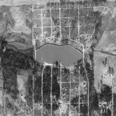
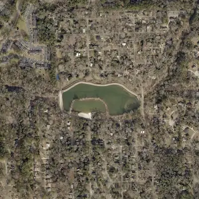
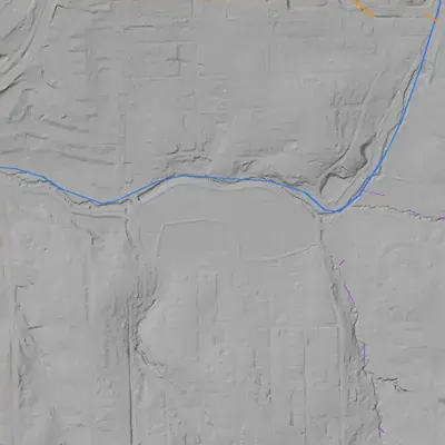
From the air
Pine Lake was drawn far down in 1955, exposing wide lakebed flats, yet its shoreline never changed. It sits beside Snapfinger Creek, not on it.
- First seen
- Already full, with cottages and a sand beach, in the earliest aerial photo from 1940.
- Dam in the lidar
- Embankments enclose the lake on a terrace: a north dike carrying a trail, and road embankments at the east and west ends. The crest stands only about 1.5 to 2 feet above the water. Height is about 12 feet measured to the creek trench outside. The north dike may partly be natural terrace. No breach.
Low water and drawdowns
- 1955: Large drawdown. Bright exposed flats fill the east, southeast and parts of the south shore. Open water remains mainly in the north and west. A pier reaches into the water.
- 1972: Partial drawdown, probably. A pale band of exposed bank, about 12 to 20 feet wide in places, rims the north, east and west shores. It was not drained.
Read from aerial photos taken between 1940 and 2026 and from DeKalb County 2024 lidar, then checked by a second reading. How the photos were read.
History
Pine Lake is a small lake in the middle of the City of Pine Lake. Wikipedia says the Pine Woods Corporation sold very small lots around a fishing lake to Atlantans as a weekend retreat, and that the lake is a widened section of Snapfinger Creek. The city incorporated in December 1937. Wikipedia also says the Army Corps of Engineers dammed the creek, but no supporting source was found and it should not be repeated as fact. The lake is not in the National Inventory of Dams, so no dam height, owner or inspection record was found. Before development the site is said to have been farmland. 123
Who built it
Wikipedia says the site was part of a farm, with corn grown in the valley, before the Pine Woods Corporation sold lots around a small fishing lake as a weekend retreat. It says the lake was a widened part of Snapfinger Creek and that the Army Corps of Engineers dammed it for erosion and flood control. No source for the Corps claim was found, and Corps work for a private lot development is unusual, so it is doubtful. The builder of the dam is unknown; a developer-built amenity is plausible but unconfirmed. 1
Timeline
- 1929Wikipedia's infobox gives 1929 as the year the area was settled. It gives no source there, and it probably refers to the start of the lake development. Uncertain 1
- Before December 1937 (exact year not given)The Pine Woods Corporation sold 20-by-100-foot lots for $69 around a small fishing lake to Atlantans, some from Buckhead, as a weekend retreat. Ads sent buyers from Decatur down unpaved Rockbridge Road East. Uncertain 1
- December 1937Pine Lake incorporated as a city, according to Wikipedia. No charter or Georgia Archives record was reached. Likely 1
- 1940Wikipedia's census table lists a 1940 population of 2. This may be a counting artifact for a mostly seasonal community, but it has not been checked against Census tables. Uncertain 1
- 1950Wikipedia's census table lists 566 residents in 1950, which may reflect weekend cottages becoming year-round homes. The reason is an inference. Likely 1
- 2020The 2020 census population is listed as 752. A documentary, Welcome to Pine Lake, about the city's all-women leadership and traffic tickets, was released in 2020. Likely 1
Names
- Pine Woods (Pine Woods Corporation)
- Developer named in Wikipedia's account of the lot sales; not confirmed against a primary source and not a documented name for the lake itself. 1
The dam
No dam record was found. The lake is not in the National Inventory of Dams (empty result for a box around the lake), so height, hazard class and rebuilds are unknown. USGS large-scale hydrography maps the waterbody at about 0.044 sq km (roughly 11 acres); Wikipedia's figure of 5 percent water in a 0.2 sq mi city would be closer to 6 acres, so the size is approximate. Georgia EPD Safe Dams was not searched. 123
Around the lake
Water
USGS maps a Snapfinger Creek flowline at the lake. Snapfinger Creek flows into the South River (an Ocmulgee River tributary), and Barbashela Creek joins Snapfinger.
Before 1861
Wikipedia says the site was part of a farm and the valley was used to grow corn before development. No land lot, mill or road history was found.
Visiting
Today
The lake at the center of the City of Pine Lake.
Getting there
The lake lies inside the City of Pine Lake. The city's own website could not be read, so who manages the lake, whether there is a public beach, and access rules are not confirmed. Check with the city before visiting.
What you can see
The lake and the small-city streets around it. Any dam, spillway or beach structures were not confirmed. HMDB lists no historical markers for Pine Lake.
Look, don’t dig. Parks, cemeteries and preserves are off limits to digging and collecting, and private land needs the owner’s permission to enter.
Open questions
- Who built the dam, when, and did the Pine Woods Corporation do it?
- Did the Army Corps of Engineers ever work on the creek here? The claim has no source.
- Is there a Georgia EPD Safe Dams record under a different name?
- How was the beach and lake used, and who was allowed to use it, in the 1930s to 1960s?
- Is the 1940 census figure of 2 accurate?
- In what year did the lot sales begin?
- Were there earlier mills or ponds on this stretch of Snapfinger Creek?
Know something? Write to hello@historyunderfoot.org. Family papers, photos and deeds often settle these.
Where to look next
- 1938-40 UGA aerial photographs of DeKalb County to show the lake and the lot pattern soon after incorporation (Digital Library of Georgia, UGA Map and Government Information Library)
- USGS topographic quadrangle editions covering Pine Lake (Stone Mountain area) to date the lake's first appearance (USGS Historical Topographic Map Collection)
- Plats and deeds for the Pine Woods Corporation subdivision, including any dam or lake tract (DeKalb County Superior Court real estate records)
- Ask about Pine Lake records, oral histories and clippings (DeKalb History Center research department)
- Charter and ordinance history of the 1937 incorporation (Georgia Archives, Morrow)
- Georgia Historic Newspapers search for Pine Lake, Pine Woods, Rockbridge Road 1930s ads (Digital Library of Georgia)