Still here · DeKalb County · Dam inventory GA01796
Ramsden Lake
A small private recreation lake with a 23-foot earthen dam just east of Stone Mountain Park; the public record found so far is only federal and county data.
From the air
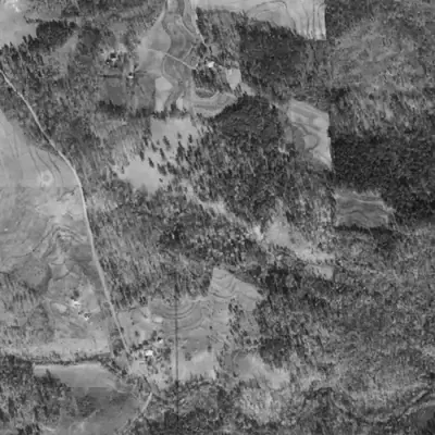
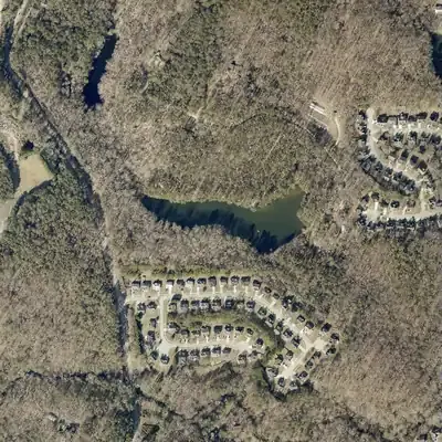
Ramsden Lake was empty woods in 1940 and a full lake with fresh bare banks by 1955. Every aerial since shows the same outline, with no drawdown.
- First seen
- Not there in 1940. Already full in 1955, with pale, fresh-looking banks that suggest it was newly built.
- Dam in the lidar
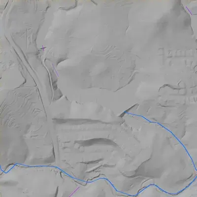
- The earthen dam runs along the southeast side, about 330 to 350 feet long. Its crest is level at roughly 832 feet, only about 2 feet above the water. The downstream face drops about 22 feet, or 25 to 26 feet to the gully below. A low spot at the east end may be an overflow spillway (uncertain). No breach.
Read from aerial photos taken between 1940 and 2026 and from DeKalb County 2024 lidar, then checked by a second reading. How the photos were read.
Depth
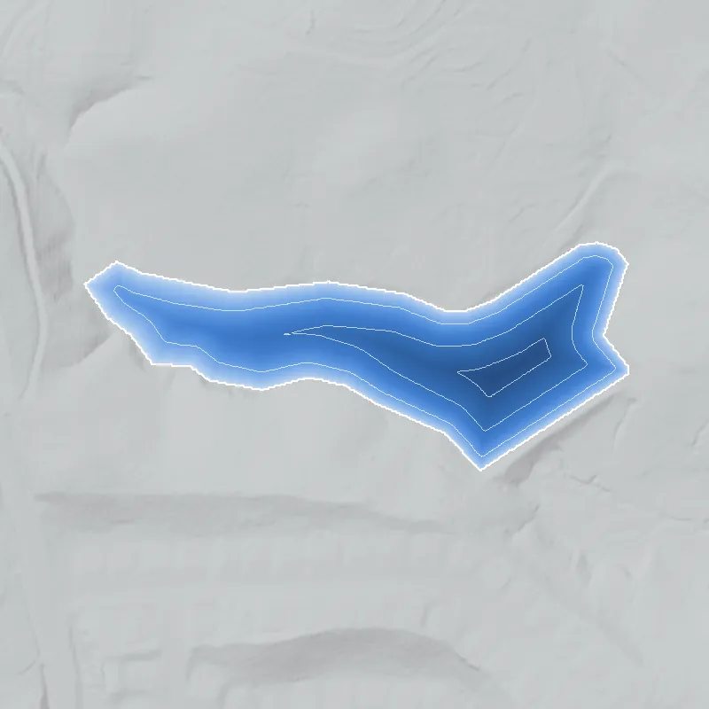
Modeled from the shoreline shape and the dam inventory’s average depth: deepest point about 17 ft. Treat it as an estimate; no survey of the lake bottom was found. How depth is estimated.
History
Ramsden Lake is a private reservoir of roughly 7 to 8 acres, about 0.4 km east of Stone Mountain Park in unincorporated DeKalb County. The National Inventory of Dams lists an earthen dam 23 feet high and 450 feet long, built for recreation, low hazard, not rated, with no completion year. Its last recorded inspection was February 20, 1984, so the dam is at least that old. USGS carries the name as a Reservoir. County GIS puts the lake on a private parcel of about 47 acres with no platted subdivision, zoned R-100, in Land District 18, Land Lot 79. No builder, date or ownership history was found. 123456
Who built it
Not documented in anything reachable. NID lists the purpose as recreation, ownership as private, the dam type as earth, the year completed as blank and the stream as 'Unknown'. USGS 3DHP shows a short first-order channel leaving the lake at its southeast end and running about 0.4 km southeast to a reach that 3DHP names Stone Mountain Creek, so this is a dammed headwater tributary. Who dug or dammed it, and when, is unknown. 13
Timeline
- Year not recordedNID lists Ramsden Lake Dam as a private, earthen recreation dam with no completion year and no modification years. Construction date and builder are unknown. 1
- February 20, 1984The date NID gives as the dam's last inspection, which means the dam and pool existed by then. NID does not say who inspected it or what was found. 1
- UndatedUSGS assigned GNIS ID 338659 to Ramsden Lake as a 'Reservoir' in DeKalb County. The gazetteer entry does not say which map edition or year first named it. 2
- September 14, 2023USGS 3DHP carries the lake as a named waterbody with a short channel flowing out of its southeast end. The layer's feature date is September 14, 2023. 3
Names
- Ramsden Lake Dam
- The National Inventory of Dams lists the structure under this name. The NID record has no other or former names. 1
The dam
NID: earthen dam, 23 ft high (hydraulic height 17 ft), 450 ft long, uncontrolled spillway, 8 surface acres, 58 acre-ft normal storage, 80 acre-ft maximum storage, drainage area recorded as 0. Hazard potential Low, condition Not Rated, no modification years listed, last inspection date February 20, 1984, NID data last updated April 20, 2021. NID marks it as not state-regulated. The county water polygon carries an elevation attribute of 828 (units not stated, probably feet). Mapped outlines measure only about 6.7 acres (USGS 3DHP) and 7.0 acres (county), smaller than NID's 8 acres. 136
- Dam height
- 23 ft
- Surface
- 8 acres
- Average depth
- about 7.2 ft
- Owner type
- Private
Figures from the U.S. Army Corps of Engineers’ National Inventory of Dams. Its “year” is often a rebuild or survey date, and average depth is storage divided by area.
Around the lake
Water
NID gives no stream for the lake. USGS 3DHP shows a first-order channel leaving its southeast end and joining a reach named Stone Mountain Creek about 0.4 km downstream. DeKalb County's stormwater basin layer places the point in the Stone Mountain Creek basin, though that layer is a coarse polygon.
Before 1861
County GIS puts the lake in Land District 18, Land Lot 79, so pre-1860 land-lot plats would cover it. Stewart Mill Rd passes about 350 m away. A mill on the local stream is a guess only and is not confirmed.
Visiting
Getting there
NID lists private ownership. The county parcel is a roughly 47-acre tract zoned R-100 with land-use code SUB and no platted subdivision attached. The platted Legacy at Pine Valley Woods subdivision (Plat Book 152, pages 36 and 44) lies about 30 m from the NID point. No public access was found and none should be assumed. Whether the water can be seen from a public street is unverified; do not enter private property.
What you can see
Unverified. USGS mapping shows an open pool of roughly 7 acres with the NID dam point at its southeast end. No historical marker, ruin or interpretive sign is known here, but none was specifically searched for.
Look, don’t dig. Parks, cemeteries and preserves are off limits to digging and collecting, and private land needs the owner’s permission to enter.
Open questions
- Who built the dam and when? NID leaves the year blank but records an inspection on February 20, 1984, so the 1956, 1992 and 1999 Snellville quadrangle editions and 1930s to 1950s aerials could bracket it.
- Is the lake tied to a private estate, a farm or a family? The name's origin is unknown and no link to a person or plat was found.
- Is Stewart Mill Rd related to a mill on this stream, and did that mill have a pond here?
- Why is the NID drainage area 0 and the stream 'Unknown'? At 23 ft and 80 acre-ft with a Low hazard rating the dam falls under Georgia's Safe Dams Act size thresholds (25 ft or 100 acre-ft), and NID marks it not state-regulated, so what was the 1984 inspection for?
- How does the lake's roughly 47-acre parcel relate to the adjoining platted subdivisions (Legacy at Pine Valley Woods, Deer Creek Unit 9), and does any plat show the lake or its dam?
Know something? Write to hello@historyunderfoot.org. Family papers, photos and deeds often settle these.
Where to look next
- Historic USGS topographic map editions covering this point. The TNM index lists Snellville, GA 7.5-minute editions from 1956, 1992 and 1999, to see when the lake first appears and under what name (USGS topoView (ngmdb.usgs.gov/topoview))
- 1930s to 1950s aerial photographs of DeKalb County, to check for a pond, mill or farm dam before subdivision. Availability of a DeKalb set through DLG or UGA Libraries was not confirmed (UGA Libraries / Digital Library of Georgia)
- Georgia EPD Safe Dams Program: ask whether any record exists for GA01796. NID marks the dam not state-regulated and its size is below the Act's thresholds, so a file may not exist (Georgia EPD Safe Dams Program)
- Recorded plats and deeds for Land District 18, Land Lot 79, including the adjoining Legacy at Pine Valley Woods (Plat Book 152, pp. 36 and 44) and Deer Creek Unit 9 (Plat Book 119, pp. 113-115), to trace how the lake's tract was divided (DeKalb County Clerk of Superior Court, plat and deed records)
- Newspaper searches for 'Ramsden Lake' and for the Stewart Mill Road area (Stone Mountain and DeKalb papers) (Georgia Historic Newspapers)
- Stone Mountain area history files, including families and mills east of the mountain (Stone Mountain Historical Society (Ridge Avenue, Stone Mountain) and DeKalb History Center)
Sources
- National Inventory of Dams, record GA01796 (Ramsden Lake Dam), public FeatureServer queried live 2026-09-29 U.S. Army Corps of Engineers
- The National Map Gazetteer (GNIS), feature 338659 Ramsden Lake, class Reservoir, DeKalb County GA U.S. Geological Survey
- 3D Hydrography Program (3DHP) lake and flowline features, waterbody LG4J7 (feature date 2023-09-14) U.S. Geological Survey
- DeKalb County GIS, TaxParcels Land_Lot layer (Land District 18, Land Lot 079) and Tax Parcels Assessment View (parcel acreage and class only; no owner data used) DeKalb County GA GIS
- DeKalb County GIS, Zoning District and LandUse layers (R-100; land-use code SUB) DeKalb County GA GIS
- Georgia EPD Safe Dams Program (Safe Dams Act thresholds: 25 ft height or 100 acre-ft, and Category I) Georgia Environmental Protection Division