Still here · DeKalb County · Dam inventory GA01322
Silver Lake
A 1911 developer's lake near Oglethorpe University, acquired with Hearst money, drained in 1978 as a dam hazard, and rebuilt in the 1980s by neighbors.
From the air
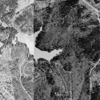
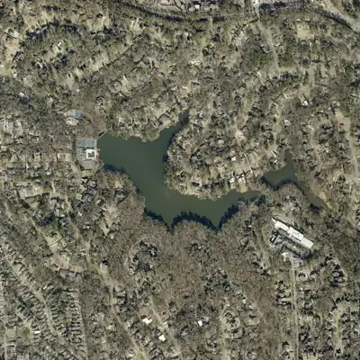
Silver Lake is already full and mature in 1940 and never appears drained in any aerial. Its dam is about 31 feet tall, a few feet above the state's record.
- First seen
- The earliest photo, from 1940, shows a mature lake with the same shape as today.
- Dam in the lidar
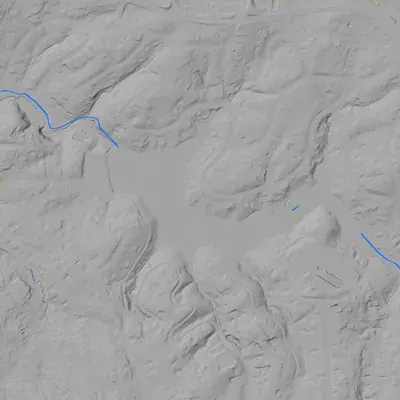
- The dam sits at the northwest corner, where the lake drains. It is about 31 feet tall at its highest point (30 to 33 feet), roughly 210 feet long, with a crest near 925 feet elevation. No breach was found. The spillway at the crest's low point drops about 30 feet to the creek.
Low water and drawdowns
- 1978 (reported state-ordered drain) possibly: No photo falls between 1972 and 1981, so a drained lake was never photographed. The 1981 image shows a full lake and a crisp dam face that may be rebuilt. Uncertain.
- 2001, Little Silver Lake only possibly: Little Silver looks like a flat orange-brown surface with a pinched southeast arm. It may be silt or a low pool, or just muddy water and tree shadow. Uncertain.
- 2005 and 2016 (reported lowerings) possibly: Not visible. The 2005 and 2017 images both show a full lake with no exposed lakebed.
Read from aerial photos taken between 1940 and 2026 and from DeKalb County 2024 lidar, then checked by a second reading. How the photos were read.
Depth
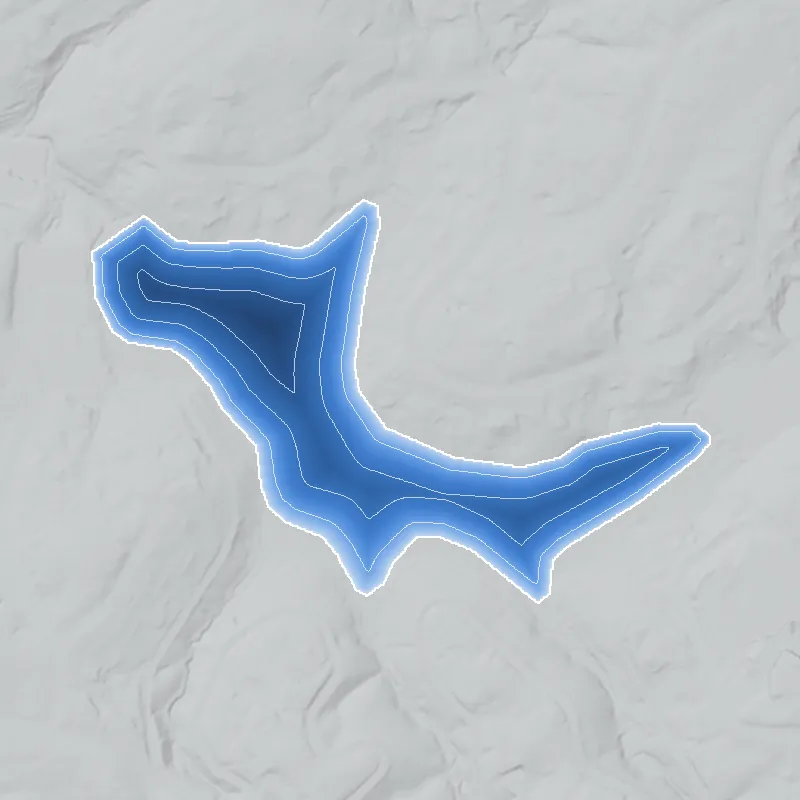
Modeled from the shoreline shape and the dam inventory’s average depth: deepest point about 20 ft. Treat it as an estimate; no survey of the lake bottom was found. How depth is estimated.
History
Silver Lake was made in 1911 by damming small tributaries of Nancy Creek, part of a real-estate venture near Peachtree Road in what is now Brookhaven. By 1929 Oglethorpe University held it, with money from William Randolph Hearst, and it was renamed Lake Phoebe for his mother, though the name did not stick. In 1978 the dam was declared a threat of disaster; the lake was drained and the dam demolished, then rebuilt in the 1980s by the neighbors' Silver Lake Civic Association, which owns it today. It is a private, members-only lake and preserve. The NID shows a 28-foot, high-hazard dam. 1234567
Who built it
The association says developer C. H. Ashford dammed several unnamed tributaries of Nancy Creek in 1911 to make a recreational lake (it gives 38 acres; Wikipedia agrees, Oglethorpe says 30, Rough Draft 28, NID 25). An Oglethorpe history quoted by Rough Draft Atlanta credits the Silver Lake Park Company and its Silver Lake Estates project, and a university history blog names Ashford and William Owen as the company's principals. The 1911 date comes from the association alone; no primary document was found. A Cambridge Park neighborhood page saying Hearst himself dammed the creek looks mistaken, since Hearst appears in the record only as a later donor. The association says the lake was built near a country club when Peachtree Road was a two-lane dirt road. Silver Creek runs into Nancy Creek, which flows to Peachtree Creek and the Chattahoochee. 12468971011
Timeline
- 1910-1912Nearby Brookhaven country-club district is laid out (150 acres bought 1910, golf course opened 1912). The association says Silver Lake was built near a country club when Peachtree Road was a dirt road. Likely 910
- 1911Silver Lake is created by damming tributaries of Nancy Creek. The association credits C. H. Ashford; an Oglethorpe history credits the Silver Lake Park Company and its Silver Lake Estates project. Likely 126
- 1913-1915Oglethorpe University is refounded on Peachtree Road. The marker says Realtor C. H. Ashford donated the land; a history blog says Ashford and William Owen of the Silver Lake Park Company gave 13.7 acres. Oglethorpe dates the cornerstone 1915; the Georgia Encyclopedia says 1913. Likely 561415
- 1929Per the association, Hearst gave $135,000 to buy the lake for Oglethorpe. The campus marker says Oglethorpe held about 600 acres by 1929, including nearby Silver Lake, 'a gift from' Hearst. Likely 15
- 1935Silver Lake is renamed Lake Phoebe, honoring Phoebe Apperson Hearst, mother of publisher William Randolph Hearst. Oglethorpe itself says only that the lake was renamed by the early 1930s. Likely 1614
- 1936Wikipedia says Hearst gave Oglethorpe 400 acres. Whether this includes the lake, or is a separate gift, is not stated in the sources found. Uncertain 11
- 1950sOglethorpe begins selling large tracts along the lake for housing, according to a neighborhood association history. Uncertain 7
- November 6, 1977The Kelly Barnes Dam fails at Toccoa Falls, killing 39 people, prompting a state investigation. 16
- 1978State inspectors find Silver Lake's dam so hazardous that Gov. George Busbee calls it 'a real and immediate threat of a disaster.' The lake is drained and the dam demolished. The association's history links this to the post-Toccoa dam crackdown. 13
- late 1970s-1980sTo pay for repairs, Oglethorpe sells more land, acting on behalf of the association, according to the Cambridge Park neighborhood page. It gives no year. Uncertain 7
- 1980The association dates the dam's restoration to 1980, with Oglethorpe's help, and says the lake and adjoining woods went to the newly formed Silver Lake Civic Association. A 2015 news report says only that the association rebuilt the dam in the 1980s. Likely 123
- before c. 1987Cambridge Park, on former Oglethorpe land beside the lake, is developed by Cousins Properties. A page published in 2017 says this was 'over thirty years ago'. Uncertain 7
- 2003Association raises funds to dredge sediment from Little Silver Lake, per its history page. Likely 1
- 2005Lake lowered for dam repairs, per the association. Likely 1
- May 2015Piedmont Geotechnical inspection finds minor maintenance issues. State records flag a bolted cover on an emergency drain pipe; the association says it is a leftover from the 1980s rebuild. 3
- 2016Lake lowered again for dam repairs, per the association. Likely 1
- January 7, 2021Latest state inspection listed in the NID: condition Satisfactory, high hazard, emergency action plan on file. 4
- July 29, 2026Contractor inspection finds woody growth on both dams (a large amount on the dam between the lakes), treats it, and clears both spillways. Little Silver Lake is heavily silted. 1217
Names
- Silver Lake Dam
- Official dam name in the National Inventory of Dams; owner listed as the Silver Lake Civic Association. 4
- Phoebe Lake Dam
- NID 'other name', a survival of the Lake Phoebe renaming. 4
- Lake Phoebe
- Name given while the lake belonged to Oglethorpe University, honoring Phoebe Apperson Hearst, mother of publisher William Randolph Hearst. The association dates it to 1935; Oglethorpe says only 'early 1930s'. A neighborhood page says the name never stuck; the association's Phoebe Trail still carries it. 1614717
The dam
NID (record updated 2021): Silver Lake Dam, Georgia Safe Dams ID 044-001-00004, gravity type, 28 ft high, 235 ft long, uncontrolled spillway and outlet, 25 surface acres, 207 acre-ft storage, private owner, high hazard, condition Satisfactory at the Jan. 7, 2021 inspection, emergency action plan on file, designer unknown, state inspection frequency listed as every 2 years, so later inspections may exist that the NID has not picked up. The NID year of 1958 conflicts with the 1911 origin and is unexplained. Its 689 sq mi drainage area is far too large for this small creek and is a data error. In 1978 a state finding that the dam was a threat of disaster led to the lake being drained and the dam demolished; the association rebuilt it in the 1980s (the association says 1980). The association says it lowered the lake for dam repairs in 2005 and 2016. In May 2015 state records flagged a bolted cover on an emergency drain pipe; the association said it is a leftover from the 1980s rebuild, not an emergency drain. A July 29, 2026 contractor inspection found a small amount of woody vegetation on the concrete dam and a large amount on the dam between the two lakes, treated both, and cleared both spillways. No public contract numbers were found for this private dam. 1341213
- Year in the inventory
- 1958
- Dam height
- 28 ft
- Surface
- 25 acres
- Stream
- Chatahoochee
- Owner type
- Private
Figures from the U.S. Army Corps of Engineers’ National Inventory of Dams. Its “year” is often a rebuild or survey date, and average depth is storage divided by area.
Around the lake
Water
Sits on Silver Creek, a tributary of Nancy Creek. Nancy Creek flows southwest through Sandy Springs and Buckhead into Peachtree Creek, then the Chattahoochee. Two impoundments in series: Silver Lake and Little Silver Lake.
Civil War
The lake did not exist in 1864, but Sherman's armies passed nearby. On July 18, 1864 columns of the Federal 16th and 23rd Corps met at Old Cross Keys (Johnson Ferry Rd at Ashford-Dunwoody Rd, about 1.2 km east by my calculation from marker coordinates). The Samuel House marker says Sherman joined Schofield that day and set up headquarters in the 1857 house on Peachtree Road (about 1.8 km southeast by my calculation from its street address).
Segregation
No source found ties the lake itself to segregation. Nearby, Lynwood Park, a historically Black neighborhood north of Windsor Parkway (about 0.65 km west by my calculation), had its own all-Black DeKalb school before desegregation, and a regional planning map labeled it an 'existing colored area'. Whether Silver Lake or Oglethorpe's lake use was restricted is not documented in what was found.
Before 1861
Nearby pre-1860 context, per Wikipedia's Brookhaven article: John Evins started a plantation around 1810, the Goodwin brothers took over the land in the 1830s, and an 1879 description says Nancy Creek powered a mill. Old Cross Keys was an antebellum crossroads with a post office. The lake itself is a 1911 creation, not an older mill pond.
Visiting
Getting there
Private. Access to the lake and woodland trails is restricted to dues-paying Silver Lake Civic Association member households (500+ households), with one accompanied guest each, and none from 15 minutes after sunset to 15 minutes before sunrise. Oglethorpe University students and faculty also have access, which the association ties to the university's historical generosity. No public access.
What you can see
For non-members, nothing is confirmed visible from public roads, and the mapped dam point lies inside the private preserve, so do not enter. Members see the concrete dam with its trough spillway, the smaller dam between the two lakes, and over a mile of trails, boardwalks and bridges, including the Phoebe Trail, which got a new bridge in August 2026. The Oglethorpe University marker on Peachtree Road (public campus) mentions Silver Lake in its text.
Look, don’t dig. Parks, cemeteries and preserves are off limits to digging and collecting, and private land needs the owner’s permission to enter.
Open questions
- Who actually built the 1911 dam: C. H. Ashford personally or the Silver Lake Park Company, and who designed or engineered it? The 1911 date itself rests on the association alone.
- Did Hearst's money buy the lake in 1929 (association) or was it a gift (campus marker), and does it belong to the 1936 400-acre gift (Wikipedia)?
- What does the NID year of 1958 represent? An earlier rebuild, a later spillway project, or a data guess? No source explains it.
- Exact scope and date of the 1978-1980s work: was the dam fully demolished and rebuilt, who was the engineer, and what permit or contract governed it? The association says 1980; the 2015 report says only the 1980s.
- When was Lake Phoebe renamed: 1935 (association), or 'early 1930s' (Oglethorpe)?
- When was the Oglethorpe cornerstone laid: 1915 (Oglethorpe, Wikipedia) or 1913 (Georgia Encyclopedia)?
- Was there any club, swimming, boating or lot-sale era in the 1910s-1940s beyond Oglethorpe student use, and were any restrictions on who could use the lake?
- Are there restrictive covenants in Silver Lake Park Company or later Oglethorpe-tract deeds (Brittany, Hampton Hall, Oglethorpe Estates, Cambridge Park)?
- Is the association's 'Atlanta's first large-scale bird sanctuary' claim documented in 1930s-40s sources? It appears only on the association's own activities page.
- Does Little Silver Lake's dam have a separate state registration? The NID has no separate record.
Know something? Write to hello@historyunderfoot.org. Family papers, photos and deeds often settle these.
Where to look next
- Georgia Historic Newspapers hits for 'Silver Lake' and 'Oglethorpe University' (112 results, 110 in 1893-1918, mostly Atlanta Georgian, Nov 1913 and Apr 5, 1914; OCR text was not read). Likely lot ads or Oglethorpe news; read page images. (Georgia Historic Newspapers (Atlanta Georgian))
- Georgia Historic Newspapers 'Lake Phoebe' results (556, 528 of them Thomasville and unrelated). Check Southern Outdoors (June 1 and July 1, 1946) and the Brookhaven Reporter (Sept 20, 2013) for this lake. (Georgia Historic Newspapers)
- Georgia EPD Safe Dams file for 044-001-00004: inspection reports, 1978 order, 1980s reconstruction permit and plans, 2005 and 2016 repair permits (open records request). (Georgia EPD Safe Dams Program)
- DeKalb Superior Court plat books and deeds: Silver Lake Park Company subdivision (c. 1911-15), Ashford-Owen 13.7-acre grant, Oglethorpe land sales in the 1950s and after 1978, and plats for Brittany, Hampton Hall, Oglethorpe Estates and Cambridge Park. (DeKalb County Clerk of Superior Court, Real Estate Division)
- Oglethorpe University Archives: Hearst gift correspondence (1929, 1936), the Lake Phoebe renaming, student water-sports records, the land sales and dam agreement. (Philip Weltner Library archives, Oglethorpe University)
- 1978 Atlanta Constitution and Journal coverage of the drained lake and Busbee's declaration; also Governor's office files. (Atlanta History Center, Georgia Archives, newspaper databases)
- Historic aerials: UGA 1938-40 DeKalb County set and GSU 1949 Atlanta set show lake extent, the dam and surrounding lots before the 1950s sales. (UGA Libraries and GSU Library aerial collections)
- USGS topographic map editions (1950s to 1990s) would show the lake outline, the name 'Lake Phoebe' if used, and the gap during the 1978-80s drawdown. (USGS topoView)
Sources
- History of Silver Lake in Brookhaven, Georgia Silver Lake Civic Association
- Residents consider Silver Lake a 'jewel' (2013) Rough Draft Atlanta
- State monitors high-hazard dams (2015) Rough Draft Atlanta
- National Inventory of Dams record GA01322 (national CSV, updated 2026-09-23; record data updated 04/20/2021) U.S. Army Corps of Engineers
- Oglethorpe University Historical Marker 044-70 (full text) Historical Marker Database
- Oglethorpe University History: 1835 in Milledgeville, 1915 on Peachtree Road Past Tense GA
- Cambridge Park Civic Association Cambridge Park Civic Association
- Nancy Creek (Atlanta) Wikipedia
- Brookhaven, Georgia Wikipedia
- Silver Lake Civic Association home page Silver Lake Civic Association
- Oglethorpe University Wikipedia
- Silver Lake Inspection Report, Q2 2026 (July 29, 2026) Silver Lake Civic Association
- Georgia Safe Dams Program Georgia Environmental Protection Division
- History and Traditions Oglethorpe University
- Oglethorpe University (New Georgia Encyclopedia) New Georgia Encyclopedia
- Kelly Barnes Dam Wikipedia
- News and updates (blog index) Silver Lake Civic Association
- Silver Lake Civic Association Inc profile (mission statement) Impala Digital