Dam breached · DeKalb County · Dam inventory GA01319
Simmons Lake
A small private recreation lake in unincorporated northern DeKalb County, in the North Fork Peachtree Creek watershed. Public records amount to a 1979-era dam listing.
Watermark
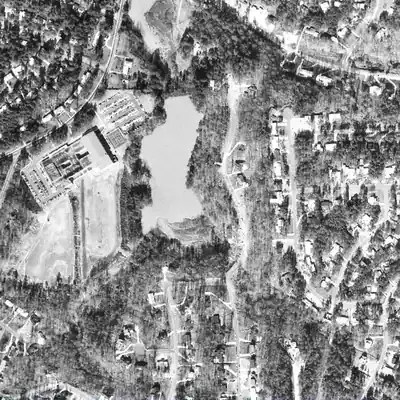
Simmons Lake, full in 1968
A private lake of roughly 8 acres in a farm valley, already there by 1940 and still full in 1968. Water was about 7 to 9 feet deep near the earthen dam at the north end.
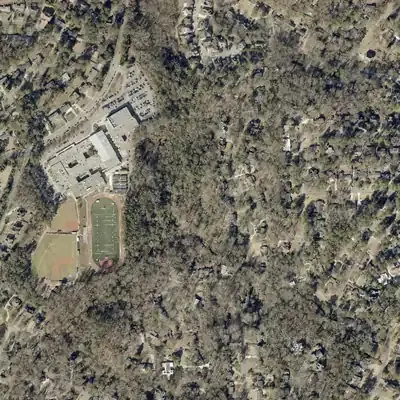
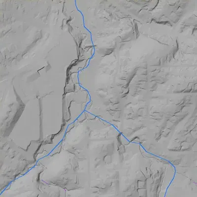
Today: The lake emptied between 1968 and 1972. The old bed is now wooded floodplain between a school and a neighborhood road, with a small stream running through a gap at the dam's west end.
- Area
- 9.5 acres
- Deepest
- about 14 ft
- Method
- Refilled from lidar
- Checked against
- 1968 aerial
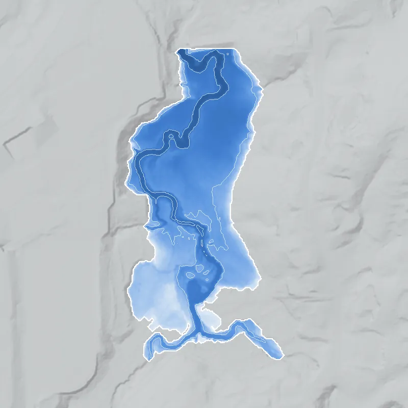
The old lakebed is still in the ground. The water was put back in the county’s lidar up to the old shoreline, with any broken dam patched, and checked against the 1968 aerial photo. Depths are reconstructed from today's ground. The blue outline includes a thin stream strip to the south that was likely never lake. The cause of the gap in the dam is unknown; no photos exist for 1973-1980. How Watermarks work.
From the air
Simmons Lake was a full 7-8 acre pond in 1968 and an empty, stream-cut bed by 1972. Its 16-foot dam still stands beside a school, with the stream now running through a gap at its west end.
- First seen
- Already built and full in the 1940 aerial, so it was made before 1940.
- Gone
- Open water was last seen in 1968. By 1972 the whole bed was drained.
- Dam in the lidar
- A short earthen bank across the north end, about 190-195 feet long and roughly 15-16 feet high, with a crest near 893 feet above sea level. A low notch in the east part of the crest was probably the spillway. At the west end there is a gap where the stream now flows out. Whether the gap is a breach, a deliberate cut or an old bypass is uncertain.
- Depth from the lidar
- The lake is long gone, so this is an estimate. With a normal water level near 890 feet, the old bed suggests about 8-9 feet of water near the dam, 7 feet mid-lake and 3-5 feet at the south end. The true depth depends on the normal water level.
Low water and drawdowns
- Between 1968 and 1972: A full pool with a crisp shoreline in 1968 became an empty bed with a winding channel, marsh and mud flats in 1972. It never refilled. The cause cannot be told from the photos.
Read from aerial photos taken between 1940 and 2026 and from DeKalb County 2024 lidar, then checked by a second reading. How the photos were read.
History
Simmons Lake is a private recreation lake in unincorporated northern DeKalb County, in the North Fork Peachtree Creek watershed. The National Inventory of Dams lists a 22-foot earthen dam about 142 feet long, 8 surface acres, and no builder, completion year or stream name. Its last inspection is dated March 1, 1979, and Georgia does not regulate the dam. Federal hydrography maps a lake named Simmons Lake about half a kilometer north of the inventory point, at under one acre, so the location or size in one record may be off. No history of the lake was found; origin and name source remain open. 1234
Who built it
Not established. NID gives purpose as recreation and dam type as earth, but no designer, builder, completion year or impounded stream ("Unknown"). The lake sits in the North Fork Peachtree Creek HUC12 watershed, but the specific tributary was not identified. 12
Timeline
Names
- Simmons Lake Dam
- Name of the dam record in the National Inventory of Dams; no alternate or former names are listed there. 1
The dam
NID record: earthen dam, 22 ft high, 142 ft long, uncontrolled spillway and outlet, 8 surface acres, 87 acre-ft storage. Hazard potential 'Undetermined', condition 'Not Rated', EAP not required, not state-regulated. Last inspection 03/01/1979; record last updated 04/20/2021. The listed 650 sq mi drainage area is implausible for a 142-ft dam on a small tributary and is probably a data-entry error. No rebuild, repair contract or engineering report was found. 1
- Dam height
- 22 ft
- Surface
- 8 acres
- Owner type
- Private
Figures from the U.S. Army Corps of Engineers’ National Inventory of Dams. Its “year” is often a rebuild or survey date, and average depth is storage divided by area.
Around the lake
Water
NID puts the dam in Georgia's DeKalb inventory with the stream 'Unknown'; USGS watershed boundaries place the point in the North Fork Peachtree Creek HUC12 (031300011201), part of the Peachtree Creek system.
Before 1861
Not sourced for this lake. Georgia Historical Society marker 044-11 (1986) records an antebellum mill on the North Fork of Peachtree Creek run by John Blake (1798-1854), about 2 km north-northwest by the map's approximate marker coordinates. Regional context only; no link to this lake is documented.
Visiting
Getting there
Private. NID lists the owner type as Private and the use as recreation (record last updated 2021). No public access, park or preserve designation was found. Owner identity is intentionally not given.
What you can see
Unknown. Nothing public was found on a visible dam, spillway or markers. Check current aerial imagery and stay off private land.
Look, don’t dig. Parks, cemeteries and preserves are off limits to digging and collecting, and private land needs the owner’s permission to enter.
Open questions
- Who built the dam, when, and for what: a private estate pond, a neighborhood or club amenity, or fishing?
- Where does the name Simmons come from: a landowner family, a subdivision, or a club?
- Is the 8-acre NID lake the same water body as the under-one-acre 'Simmons Lake' in USGS hydrography about 0.5 km north, and which location is right?
- Which tributary of North Fork Peachtree Creek does it impound (NID says 'Unknown')?
- Is the lake still full, and has the dam been repaired or breached since the 1979 inspection?
- Why is the dam not state-regulated, and why is hazard class still 'Undetermined'?
Know something? Write to hello@historyunderfoot.org. Family papers, photos and deeds often settle these.
Where to look next
- UGA 1938-40 DeKalb County aerial photographs: check whether a pond exists at the site before subdivision development (UGA Libraries Map and Government Information Library / Digital Library of Georgia, historic aerials)
- USGS 7.5-minute topo editions for the Chamblee / Northeast Atlanta quadrangles (1950s-1970s): date when the lake first appears, and which of the two mapped locations it occupies (USGS Historical Topographic Map Explorer)
- DeKalb County plat records and subdivision plats for the surrounding street grid; the lake may be a plat amenity or easement (DeKalb County Clerk of Superior Court, Real Estate records)
- Georgia EPD Safe Dams Program file for state ID 044-011-00151 (1979 inspection report, owner correspondence) (Georgia EPD Safe Dams Program)
- Newspaper search on 'Simmons Lake' plus DeKalb, Tucker or Northlake in Georgia Historic Newspapers and Atlanta Constitution/Journal archives (Digital Library of Georgia, Georgia Historic Newspapers)
- DeKalb History Center archives for local family, subdivision and pond histories in the Northlake/Briarcliff area (DeKalb History Center, Decatur)
Sources
- National Inventory of Dams, full national CSV export (record GA01319, Simmons Lake Dam; data updated 2026-9-23; record itself last updated 04/20/2021) U.S. Army Corps of Engineers, National Inventory of Dams
- USGS Watershed Boundary Dataset (HUC12 031300011201, North Fork Peachtree Creek), point query at 33.84444, -84.28195 U.S. Geological Survey, The National Map
- USGS National Hydrography Dataset, Waterbody - Large Scale layer (feature 'Simmons Lake', GNIS ID 00326075, about 0.74 acre, near 33.849, -84.283) U.S. Geological Survey, The National Map
- U.S. Census Bureau Geocoder, geographies for coordinates 33.84444, -84.28195 (DeKalb County; no incorporated place returned) U.S. Census Bureau