Still here · DeKalb County · Dam inventory GA01325
Stone Mountain Lake
A 60-foot earth dam on Stone Mountain Creek made this park lake in the early 1960s, drowning part of old Highway 78 beside the granite mountain.

From the air
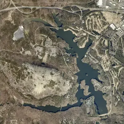
In 1955 old Highway 78 ran down the valley where the lake now lies. By 1968 the lake was full, and it has stayed full in every image since.
- First seen
- Not there in 1955; the 1968 aerial is the first to show the lake, already full.
- Dam in the lidar
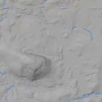
- An earth embankment at the south-east end carries the park road. Its crest is level at about 852 ft, roughly 15 ft above the lake. It is about 63 ft high at the tallest point and 830 to 940 ft long. A spillway notch and chute sit at the east end. No breach.
Read from aerial photos taken between 1940 and 2026 and from DeKalb County 2024 lidar, then checked by a second reading. How the photos were read.
Depth
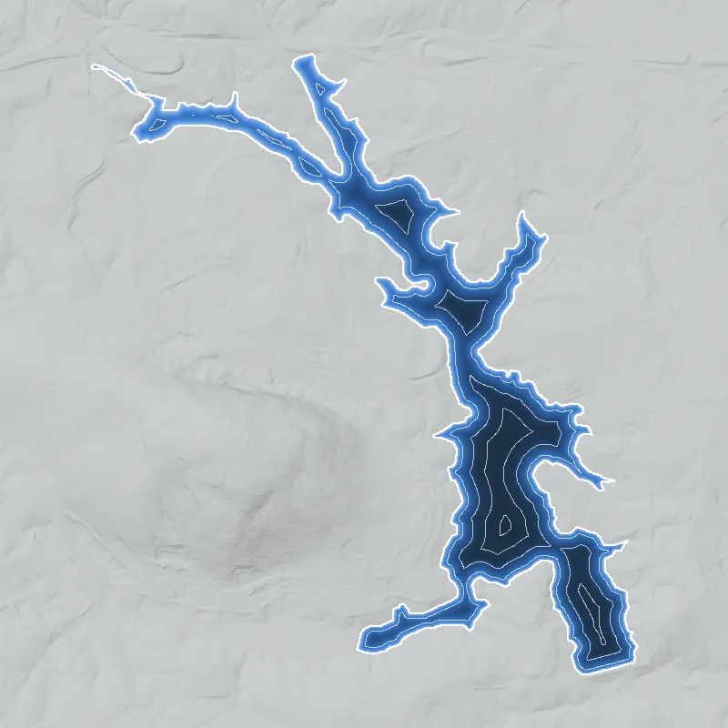
Modeled from the shoreline shape and the dam inventory’s average depth: deepest point about 43 ft. Treat it as an estimate; no survey of the lake bottom was found. How depth is estimated.
History
Stone Mountain Lake is the big lake in Stone Mountain Park, built in the late 1950s and early 1960s after Georgia bought the mountain in 1958. Robert and Company Associates drew a 1958 master plan that called for a large lake partly ringing the mountain; the NID lists its 60-foot, 1,025-foot-long earth dam as completed in 1961, though a contractor gives 1965. Park size figures range from 323 to 392 acres. The lake covered part of U.S. Highway 78, has silted up from a 13.6-square-mile watershed, and had its spillway rebuilt in the late 1990s. Access is through the paid park; swimming is banned. Construction records are thin online. 1234567
Who built it
The state legislature created the Stone Mountain Memorial Association (SMMA) in 1958 to buy the mountain and run it as a Confederate memorial and a place of public recreation. The association hired the Atlanta architecture and engineering firm Robert and Company Associates that year for a master plan, which included a large lake partly encircling the mountain. A 2022 article in the Journal of the Society of Architectural Historians quotes the firm saying the wish to honor Confederate leaders was now probably secondary to the economic motive, and says the association chose lakes and scenic drives over commemoration by summer 1959. The NID names Robert and Company Associates as the dam's designer, and the SMMA's own timeline puts the dams, lake impoundments, marina and a prison camp for park labor in the 1958-63 first phase under general manager Scott Candler. The lake impounds Stone Mountain Creek. When it was built in the 1960s it covered a part of U.S. Highway 78 that had passed through the middle of the park. The sources I could open do not name the earthmoving contractor or say exactly when the lake filled. 872193
Timeline
- 1821The Treaty of Indian Springs, signed with a faction of the Creek, cedes the land that becomes DeKalb County, created in 1822 from Henry, Gwinnett and Fayette counties. Likely 1112
- July 18-19, 1864Union cavalry and a 15th Corps brigade destroy Georgia Railroad track, culverts, a water tank and stores near the Stone Mountain depot, roughly 3 miles west-northwest of the future dam site. 1314
- November 1864Sherman's report says General Slocum moved with the Twentieth Corps by Decatur and Stone Mountain, with orders to tear up the railroad, at the start of the March to the Sea. 15
- 1958Georgia creates the Stone Mountain Memorial Association and buys the mountain (about $1.1 million per the Atlanta History Center, about $2 million per the New Georgia Encyclopedia). Robert and Company Associates plans a lake partly encircling it. 831172
- 1958-1963First construction phase under general manager Scott Candler: dam(s) and lake impoundments, marina, Stone Mountain Inn and a prison camp for park labor. The lake covers part of Highway 78, which ran through the park. 2
- 1960NID year completed for the small Stone Mountain Park Dam-South (39 acres), on the same creek about 1.3 km west of the main dam. Uncertain 1
- 1961NID year completed for the main dam; the SMMA master plan says only 'early 1960s'. A contractor page gives 1965. Uncertain 125
- April 14, 1965Stone Mountain Park's own timeline gives this as the official opening, operated by Berlio of Georgia; the SMMA timeline lists the Stone Mountain Inn's official opening on the same date. 162
- 1965The park's timeline says the covered bridge is moved to the park from Athens. Wikipedia adds an 1891 build date, a $1 purchase and new piers reaching an island in the lake; the SMMA plan dates the move only to 1964-68. Likely 16172
- 1968The park's beach is completed, along with the Robert Trent Jones golf course. A water slide is added to the beach in 1977. 216
- 1976The Scarlett O'Hara riverboat is built at Stone Mountain Park; the sources do not say which lake it operated on. Likely 16
- August 11 and February 6, 1978Per an ASDSO abstract, the state inventories the dam under the Safe Dams Act of 1978 on August 11 and classifies it Category I on February 6, 1978. The date order looks odd. Likely 10
- 1993A state Safe Dams inspection finds the spillway chute and control section need replacement; SMMA gets approval for minimal corrective measures and postpones full replacement until after the 1996 Olympics. 10
- 1998-1999J. M. Wilkerson builds a new concrete spillway; NID lists a 1998 modification, and the work won a 1999 ACI Award of Excellence. Exact dates are not stated. Likely 5110
- 2005-2008The 2005 master plan amendment says the lake has been silting up since the early 1960s and lists a three-year project to remove silt from the upper reaches starting in 2008. Whether it happened is not confirmed. 2
- March 16, 2017Latest NID inspection listed: condition Satisfactory, high hazard, emergency action plan on file. 1
- March 22, 2022The covered bridge over the lake, named for its builder Washington W. King by the SMMA in 2019, is listed on the National Register of Historic Places, per Wikipedia citing the NPS register. Likely 17
Names
- Stone Mountain Park Lake
- Name used by the National Inventory of Dams (dam: Stone Mountain Park Lake Dam) and by Georgia EPD's lake water-quality monitoring site. 118
- Stone Mountain Lake
- Name used by the park, the Stone Mountain Memorial Association and its 2005 master plan for the 323-acre main lake. 26
- Stone Mountain Park Dam-North and Dam-South
- Not alternate names. These are separate small NID dams on the same creek inside the park (GA01962, 1965, 6 acres; GA01327, 1960, 39 acres), not the main lake. 1
The dam
NID: Stone Mountain Park Lake Dam, an earth dam 60 ft high and 1,025 ft long, completed 1961 (a 1998 modification is listed), 392 surface acres, 5,600 acre-feet normal and 8,470 acre-feet maximum storage, high hazard, condition Satisfactory as of the March 16, 2017 inspection, with an emergency action plan and a two-year inspection cycle (NID dam record last updated April 2021). Georgia Safe Dams ID 044-003-00037. The ASDSO abstract says the State Soil and Water Conservation Committee inventoried the dam on August 11, 1978 and classified it a Category I Large Dam on February 6, 1978 (dates as printed, in that odd order). A 1993 state inspection found the grouted riprap-lined spillway chute and concrete control section needed replacement because of deterioration and age. The SMMA got approval for minimal corrective measures and postponed full replacement until after the 1996 Olympics. J. M. Wilkerson Construction's project page describes the replacement spillway: 67 ft wide, over 4,000 cubic yards of concrete, finished in under seven months and six weeks ahead of schedule, and winner of a 1999 ACI Award of Excellence. Conflicts: NID year 1961 vs Wilkerson's 1965; acreage 392 (NID), 323 (park and SMMA), 363 (Wilkerson); NID drainage 9,043 sq mi is wrong. I found no public contract numbers. 110524
- Year in the inventory
- 1961
- Dam height
- 60 ft
- Surface
- 392 acres
- Average depth
- about 14.3 ft
- Stream
- Stone Mountain Creek
- Owner type
- Private
Figures from the U.S. Army Corps of Engineers’ National Inventory of Dams. Its “year” is often a rebuild or survey date, and average depth is storage divided by area.
Around the lake
Water
Stone Mountain Creek and several tributaries enter the park from the north and west and leave below the main dam. USGS says the lake's 13.6 sq mi drainage is 48.4 percent of the 28.08 sq mi Stone Mountain Creek watershed measured at the GA 124 gage downstream, and that the lake and two smaller downstream reservoirs retain sediment and reduce nutrients. The creek is in the Yellow River basin, part of the Ocmulgee system. The park's 2005 plan blames silt mainly on the Mountain Industrial Boulevard and Smoke Rise areas.
Civil War
The 1864 Georgia Railroad raids hit the Stone Mountain depot roughly 3 miles west-northwest of the dam (HMdb/GHS marker), and the XX Corps passed through in November 1864. Separately, the park itself was created as a Confederate memorial. No 1864 camp is documented on the lake site itself.
Segregation
A 2022 architectural history of the park says that when it was planned in 1958-59, Stone Mountain Park, like all of Georgia's public parks, would be segregated, in the context of Gov. Griffin's resistance to school integration. The park opened in 1965 and the beach in 1968. I found no source on when Black visitors were first admitted or whether the beach was ever segregated.
Before 1861
The area was Creek land until the 1821 cession. The Venable family owned the mountain before the state bought it in 1958. Highway 78 crossed the valley before the lake, but no pre-1860 land lot, mill or farmstead on the lake bed is documented in what I could open.
Visiting
Getting there
Inside Stone Mountain Park, run by the SMMA, a state authority that leases commercial operations to a private operator (Herschend Family Entertainment since 1998, per the SMMA). A daily or annual parking pass is required. Fishing is allowed 6 a.m. to midnight with a Georgia license; the park lists bass, carp, crappie, catfish and bream. Private boats are limited to daylight hours and 10 hp motors, with a ramp at the south end near the dam and Evergreen hotel; motorized boats must be registered with Georgia DNR. Kayak and paddleboard rentals run July to October, weather permitting. Swimming is prohibited in all park waters. NID labels the owner 'Private', although the SMMA is a state authority.
What you can see
Shoreline walks and drives, the boat ramp at the south end near the dam, the covered bridge to an island in the lake (Indian Island is the lake's accessible island, per a park guide), and kayak or paddleboard rentals in season. Whether the spillway and stepped chute below the dam can be seen from public areas is not confirmed. The park also has Venable Lake, which is not open to boating.
Look, don’t dig. Parks, cemeteries and preserves are off limits to digging and collecting, and private land needs the owner’s permission to enter.
Open questions
- What exact year did the lake fill: 1961 (NID), c. 1963-65, or later? The record is contradictory (NID 1961, Wilkerson 1965, master plan 'early 1960s').
- Who built the dam and cleared the reservoir, and what did it cost? Only the designer, Robert and Company Associates, is named.
- Is NID's Stone Mountain Park Dam-South (1960, 39 acres) the dam of Venable Lake, and what is the 6-acre Dam-North? Neither is named in sources I could open.
- Were the beach and lake open to Black visitors from 1965 or 1968, or did integration come later?
- Did the 2008 silt-removal project happen, and did it involve a drawdown?
- What mills, roads, farmsteads or cemeteries lay in the flooded valley before the 1960s?
- What did the 1998-99 spillway project cost, and what was the SMMA's contract number?
- When exactly was the Category I classification made, given the ASDSO abstract prints February 6, 1978 after an August 11, 1978 inventory?
Know something? Write to hello@historyunderfoot.org. Family papers, photos and deeds often settle these.
Where to look next
- Georgia Safe Dams Program file for dam 044-003-00037 (inspection reports, 1978 classification, spillway design), by open-records request to EPD. (Georgia EPD Watershed Protection Branch, Safe Dams Program)
- Full 1999 ASDSO conference paper by James C. Garrison III and Karl W. Myers on the spillway replacement (abstract is public, full text members-only). (Association of State Dam Safety Officials)
- Historic aerials of the Stone Mountain Creek valley before impoundment: UGA 1938-40 DeKalb County aerial set. Compare with later frames to see the lake fill. (UGA Libraries Map and Government Information collection)
- USGS Stone Mountain 7.5-minute quadrangle, editions before and after the early 1960s, to bracket when the lake appears and where old Highway 78 ran. (USGS Historical Topographic Map Collection (topoView))
- Atlanta Constitution and Atlanta Daily World coverage of the lake, the 1965 opening and Black access, 1958-1968. (Newspaper archives (Atlanta History Center, Georgia State University library))
- Lane Brothers Commercial Photographers negatives of Stone Mountain Park, 1950-1969 (e.g., the Skylift drawing); search the collection for lake, dam and marina construction views. (Georgia State University Library, Digital Library of Georgia)
- Robert and Company Associates 1958 master plan and SMMA board minutes; ask whether the Atlanta History Center or Georgia Archives holds them. (Atlanta History Center Kenan Research Center; Georgia Archives)
- 2005 SMMA Master Plan Amendment Report (public PDF) with lake acreage, siltation and history timeline. (Stone Mountain Memorial Association)
- Georgia Historical Society marker file for Garrard's Cavalry at Stone Mtn. Depot (1954) for the 1864 raid context. (Georgia Historical Society / HMdb)
Sources
- USACE National Inventory of Dams national CSV (rows GA01325, GA01327, GA01962; data updated 2026-09-23, dam records updated 2021) US Army Corps of Engineers
- Master Plan Amendment Report, Georgia's Stone Mountain Park (Aug 15, 2005) Stone Mountain Memorial Association
- A Condensed History of the Stone Mountain Carving Atlanta History Center
- Hydrology and water quality in 15 watersheds in DeKalb County, Georgia, 2012-16 (SIR 2021-5126) US Geological Survey
- Stone Mountain Spillway (project page) J. M. Wilkerson Construction
- Boating Stone Mountain Memorial Association
- The 1960s Antebellum Plantation at Stone Mountain, Georgia Journal of the Society of Architectural Historians, 2022
- History of SMMA Stone Mountain Memorial Association
- What is SMMA Stone Mountain Memorial Association
- Stone Mountain Lake Spillway Replacement (Garrison and Myers, 1999 conference paper page) Association of State Dam Safety Officials
- Stone Mountain New Georgia Encyclopedia
- DeKalb County, Georgia Wikipedia
- Garrard's Cavalry at Stone Mtn. Depot (marker 044-16) Historical Marker Database
- Garrard's Cavalry at Stone Mtn. Depot (marker, 1954) Georgia Historical Society
- Official Records, series 1, vol. 44, Sherman's report Ohio State University eHistory
- History - Stone Mountain Park Stone Mountain Park (operator website)
- Washington W. King Bridge Wikipedia (cites NPS NRIS)
- Stone Mountain Park Lake, site 21GAEPD_WQX-LK_04_15231 Georgia EPD via Water Quality Portal