Still here · DeKalb County · Dam inventory GA01327
Stone Mountain Park Dam-South (Venable Lake)
A 16-foot earthen recreation dam on Stone Mountain Creek inside Stone Mountain Park, listed in the National Inventory of Dams as 'Dam-South' and in USGS names as Venable Lake.

From the air
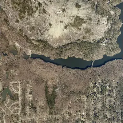
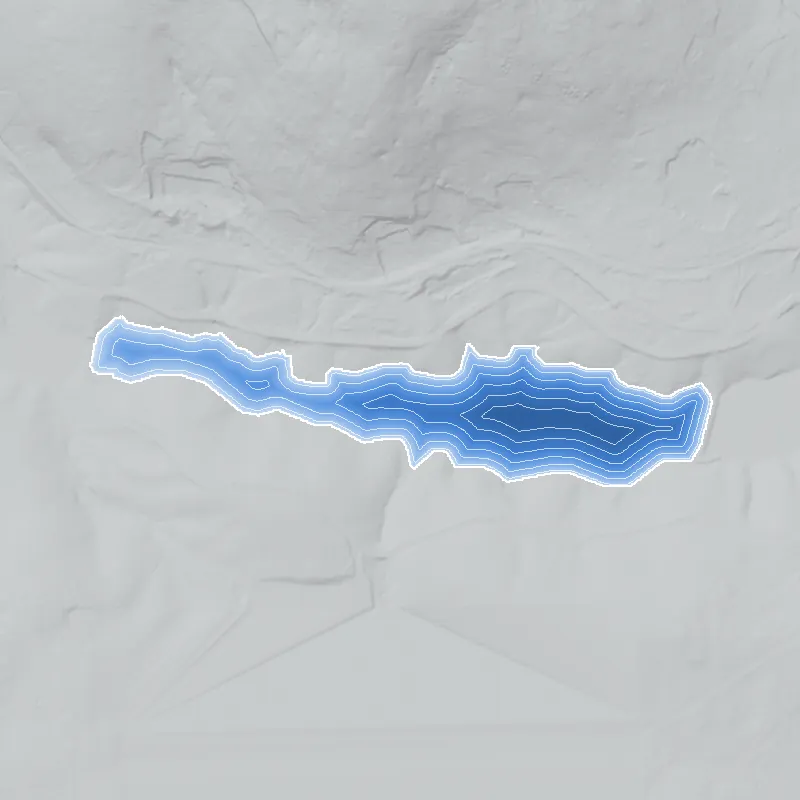
A small pond sat in this valley in 1940 and 1955. By 1968 a causeway dam had raised it into today's lake, about 3,640 feet long, and its shoreline has not moved since.
- First seen
- 1940, as a small pond on the east side of the valley; that photo does not cover the western part.
- Dam in the lidar
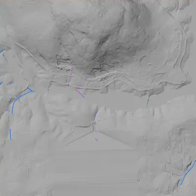
- A narrow earthen causeway at the east end carries a trail. It is about 25 feet wide and 400 feet long, with a crest near 845.6 feet elevation. Its height is at least 9 feet, because the downstream base is underwater. No breach or spillway channel is visible.
Read from aerial photos taken between 1940 and 2026 and from DeKalb County 2024 lidar, then checked by a second reading. How the photos were read.
Depth
Modeled from the shoreline shape and the dam inventory’s average depth: deepest point about 13 ft. Treat it as an estimate; no survey of the lake bottom was found. How depth is estimated.
History
The National Inventory of Dams lists Stone Mountain Park Dam-South as a 16-foot earth dam, 408 feet long, holding about 228 acre-feet across 39 acres for recreation on Stone Mountain Creek. It dates the dam to 1960 with an unknown designer, two years after Georgia bought the mountain from the Venable family and five years before the park opened on April 14, 1965. The USGS place-name database lists a lake called Venable Lake, and a reservoir called Stone Mountain Park Lake-South, at the same point near the dam. The record shows a low hazard rating, no condition rating and an uncontrolled spillway. No builder, contract or lake-specific event turned up. 1234
Who built it
Not documented in the sources I could reach. The NID gives the purpose as recreation, the dam type as earth, the stream as Stone Mountain Creek, and the year completed as 1960 with an unknown designer. Context: Georgia bought Stone Mountain in 1958, the Stone Mountain Memorial Association (created 1941 and made a state authority in the late 1950s) developed the grounds, and the park opened April 14, 1965. None of that shows who built this dam. 123
Timeline
- 1887Venable Brothers of Atlanta buy Stone Mountain for $45,000 and quarry it for 24 more years. Venable descendants keep ownership until 1958. Likely 2
- 1958State of Georgia buys Stone Mountain from the Venable family. Sources disagree on price: the legislature approved $1,125,000 (Wikipedia); the New Georgia Encyclopedia says about $2 million. 23
- 1960NID lists this dam as completed, with designer unknown. NID years are often estimates, so treat 1960 as approximate. Uncertain 1
- 1960Land at the base of the mountain owned by James R. Venable is condemned at the request of the Stone Mountain Memorial Association, per Wikipedia. Likely 2
- 1961NID lists the main Stone Mountain Park Lake dam (GA01325; 392 acres, 60 ft high) as completed. Also an unconfirmed inventory year. Uncertain 1
- April 14, 1965Stone Mountain Park officially opens. Likely 2
- May 2005Latest inspection date recorded in the NID for this dam (inspection frequency 5 years). 1
- April 20, 2021NID record for this dam last updated; hazard Low, condition Not Rated. 1
Names
- Stone Mountain Park Dam-South
- Official National Inventory of Dams name for record GA01327. 1
- Venable Lake
- Name of a USGS place-name (GNIS) entry, Feature ID 358273, class Lake, DeKalb County. It sits at the same mapped point as a second entry, 'Stone Mountain Park Lake-South' (ID 337910, Reservoir), and about 0.5 km west of this dam's NID coordinates. The NID record itself has no other-names value. No source found explains who the name honors; a link to the Venable family, who owned the mountain from 1887 to 1958, is a likely but unsourced inference. 14
- Stone Mountain Park Lake-South
- USGS place-name (GNIS) entry, Feature ID 337910, class Reservoir. It parallels a 'Stone Mountain Park Lake-North' entry and mirrors the NID's Dam-South and Dam-North names. A separate GNIS entry, 'Stone Mountain Park Lake', marks the main lake to the east. 4
The dam
NID: earthen dam 16 ft high (hydraulic height 15 ft), 408 ft long, buttress core type, foundation unlisted. Uncontrolled spillway and outlet; maximum storage 325 acre-feet, normal storage 228 acre-feet, 39 surface acres. Hazard potential Low; condition Not Rated. State jurisdiction and state inspection are marked Yes (state ID 044-082-01107), though 'state regulated' is No. Last recorded inspection May 2005, with a 5-year frequency; record updated April 20, 2021. The NID lists the owner type as 'Private', as it does for the park's other dams, which sits oddly with a state-authority park and may be a coding artifact. Drainage area is entered as 0, so that field is unfilled. No rebuild, drawdown or repair contract was found. 1
- Year in the inventory
- 1960
- Dam height
- 16 ft
- Surface
- 39 acres
- Average depth
- about 5.8 ft
- Stream
- Stone Mountain Creek
- Owner type
- Private
Figures from the U.S. Army Corps of Engineers’ National Inventory of Dams. Its “year” is often a rebuild or survey date, and average depth is storage divided by area.
Around the lake
Water
NID places the dam on Stone Mountain Creek. No watershed delineation found, and the NID drainage-area field is 0.
Segregation
Park-level context only. Wikipedia says the state bought the mountain in 1958 at the urging of segregationist Governor Marvin Griffin, following Brown v. Board of Education. No source found on who could use this lake, or any beach or boating area on it, during the segregation era.
Visiting
Getting there
Inside Stone Mountain Park, run by the Stone Mountain Memorial Association, a state authority. I could not fetch the park's website, so I could not confirm current fees or whether this water body has public shoreline, boating or fishing access. Check with the park before visiting.
What you can see
Unverified. No source found describing a dam viewpoint, spillway, or marker at this lake. The park is a public site: stay on marked trails and roads.
Look, don’t dig. Parks, cemeteries and preserves are off limits to digging and collecting, and private land needs the owner’s permission to enter.
Open questions
- Is this 39-acre impoundment a separate pond, or an arm or upstream section of Stone Mountain Lake? What does the park call it today?
- Who designed and built the dam, and was it built in 1960 or later, during the Memorial Association's build-out toward the 1965 opening?
- Who or what is the name 'Venable Lake' for, and when did it first appear on maps?
- Why does the NID list the owner as Private when the park is run by a state authority?
- Was the lake open to swimming, boating or fishing during the segregation era, and who was admitted?
- Have there been rebuilds, drawdowns, or Georgia EPD Safe Dams inspections since the 2005 entry?
Know something? Write to hello@historyunderfoot.org. Family papers, photos and deeds often settle these.
Where to look next
- Georgia EPD Safe Dams Program file for dam ID 044-082-01107: inspection reports, classification, and any repair or as-built plans. (Georgia Environmental Protection Division, Safe Dams Program (open-records request))
- 1938-40 UGA DeKalb County aerial photographs, to check whether any impoundment existed on Stone Mountain Creek before the state bought the land. (Digital Library of Georgia / UGA Libraries Map and Government Information Library, historic aerials)
- USGS 7.5-minute Stone Mountain quadrangle editions (1950s, 1960s, 1970s), to date the first appearance of the lake and its name. (USGS Historical Topographic Map Collection (topoView))
- Stone Mountain Memorial Association records and board minutes from 1958-1965 on park construction and lake work. (Georgia Archives, Morrow, or SMMA (open-records request))
- Newspaper coverage of park construction and lake openings, 1958-1965 (Atlanta Constitution, Atlanta Journal, DeKalb New Era). (Georgia Historic Newspapers (Digital Library of Georgia), Atlanta History Center archives)
- Venable family and Venable Brothers Granite Company papers, to see whether a pond existed on the property before 1958. (Atlanta History Center Kenan Research Center; DeKalb History Center)
Sources
- National Inventory of Dams, record GA01327 (Stone Mountain Park Dam-South), FeatureServer query; also GA01325 and GA01962 by area query U.S. Army Corps of Engineers
- Stone Mountain (Wikipedia; 1887 Venable purchase, 1958 state purchase and price, Marvin Griffin, 1960 condemnation, April 14, 1965 park opening) Wikipedia
- Stone Mountain (New Georgia Encyclopedia; 1958 state purchase for about $2 million, SMMA established 1941 and made a state authority in the late 1950s) New Georgia Encyclopedia
- The National Map Gazetteer (GNIS), Other Hydrographic Features layer: Venable Lake (ID 358273), Stone Mountain Park Lake-South (ID 337910), Stone Mountain Park Lake (ID 337906) U.S. Geological Survey