Drained · DeKalb County · Dam inventory GA01962
Stone Mountain Park – North
A 6-acre pond behind a 27-foot earth dam on Stone Mountain Creek at the northern edge of Stone Mountain Park, listed in the federal dam inventory as a 1965 recreation dam.
Watermark
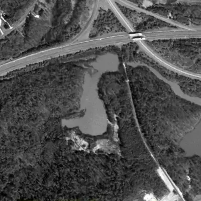
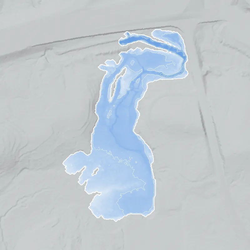
Stone Mountain Park North pond, full in 1981
A roughly 9-acre pond filled this valley beside the new freeway interchange and park road, first seen in 1972 and still full in 1981. It was mostly 2 to 3 feet deep, and about 5 feet at the deepest.
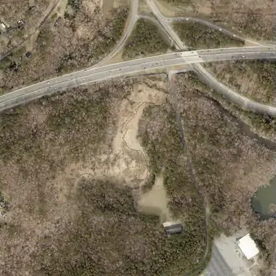
Today: The pond is gone. The old bed is a flat, silted meadow and marsh with a small stream winding across it, and only a tiny puddle at the southeast corner.
- Area
- 8.7 acres
- Deepest
- about 5 ft
- Method
- Refilled from lidar
- Checked against
- 1981 aerial
The old lakebed is still in the ground. The water was put back in the county’s lidar up to the old shoreline, with any broken dam patched, and checked against the 1981 aerial photo. Water level is estimated at about 841 ft, and the bed has silted, so the old pond was likely deeper. The exact dam is uncertain; the park road fill probably held the water. How Watermarks work.
From the air
This pond did not exist in 1968. It appears by 1972 beside a new freeway interchange, and by 2021 it had turned into a dry, silted bed.
- First seen
- The pond first appears in the 1972 photo. The 1955 and 1968 photos show only woods.
- Gone
- No open water has been seen since 2021. The last open water was in 2017.
- Dam in the lidar
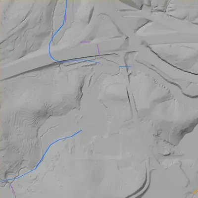
- The dam is uncertain. The best fit is the park road fill at the northeast corner, about 16 feet high and 165 feet long where the old water touched it. A low bank about 6 to 12 feet high forms the north edge. No breach or spillway is visible.
- Depth from the lidar
- The county's 2024 lidar survey caught the bed dry. Assuming a normal water level near 841 feet, the pond was typically 2 to 3 feet deep, with a 5-foot maximum in the channel. These are minimums, because silt has since filled the bed.
Low water and drawdowns
- Between 1981 and 1993: The 1993 photo shows a mud and vegetation floor with channels and no open water. By 2001 it is a marsh. The cause is unknown, and the lidar shows no breach.
- Between 2005 and 2017: Water shrinks to the south half by 2012 and to a smaller south pool by 2017. This looks like gradual loss and silting, not one draining.
- 2021 to 2026: Every photo shows a dry bed with a winding channel and one small puddle in the southeast corner.
Read from aerial photos taken between 1940 and 2026 and from DeKalb County 2024 lidar, then checked by a second reading. How the photos were read.
History
The National Inventory of Dams lists an earth dam 27 feet high and 395 feet long on Stone Mountain Creek. It holds a 6-acre pond, with 24 acre-feet normally stored and 112 at maximum. The uncontrolled spillway serves a recorded drainage area of about 19 square miles. Georgia's Safe Dams program rates its hazard Low; the condition is 'Not Rated'. NID gives 1965 as the completion year, the same year the park opened, but the figure is unverified. The record names no designer. No narrative history of this pond turned up, so its origin and use are unsettled. 12
Who built it
Not documented in any source reached. NID lists the purpose as Recreation and the year completed as 1965, with the designer 'UNKNOWN'. The site lies inside today's park boundary, and the park officially opened April 14, 1965 (Wikipedia, single source), so the NID year may reflect park construction, but that is inference. When the state acquired this particular land is not documented in the sources reached. 123
Timeline
- 1958Georgia buys Stone Mountain and creates the Stone Mountain Memorial Association as a state authority. Sources disagree on the price: about $1.1 million (Atlanta History Center) versus about $2 million (New Georgia Encyclopedia). 45
- 1964Work on the Confederate carving resumes under Governor Carl Sanders; the state issues $5 million in bonds to fund completion. 4
- April 14, 1965Stone Mountain Park officially opens, per Wikipedia. NID separately lists this dam as completed in 1965; that figure may be an estimate, and no source links the two. Uncertain 12
- May 9, 1970Carving formally unveiled at a ceremony attended by Vice President Spiro Agnew; the work was officially completed in 1972. 4
- 1998The Memorial Association enters a public-private partnership with Herschend Family Entertainment to manage the park's commercial operations. Herschend ended its lease early, in 2018. 5
- May 1, 2005Last inspection date recorded in NID for this dam. 1
- April 20, 2021NID record for this dam last updated; hazard Low, condition Not Rated. 1
- May 23, 2022Memorial Association approves Thrive Attractions Management Group as attractions manager, per Wikipedia (single source). Likely 2
Names
- Stone Mountain Park Dam-North
- Structure name in the National Inventory of Dams (NID). No local or historic name was found for the pond. 1
The dam
Earth embankment with a buttress core type. NID lists structural height 27 ft, hydraulic height 21 ft, length 395 ft, uncontrolled spillway and outlet. The impounded stream is Stone Mountain Creek. Regulation: state jurisdiction and state inspection, but not state permitting. Hazard is Low and condition is Not Rated. The last NID-recorded inspection was May 1, 2005, on a 5-year frequency, and the record was last updated April 20, 2021. No rebuild or engineering contract was found. 1
- Year in the inventory
- 1965
- Dam height
- 27 ft
- Surface
- 6 acres
- Average depth
- about 4 ft
- Stream
- Stone Mountain Creek
- Owner type
- Private
Figures from the U.S. Army Corps of Engineers’ National Inventory of Dams. Its “year” is often a rebuild or survey date, and average depth is storage divided by area.
Around the lake
Water
NID places the dam on Stone Mountain Creek and records a drainage area of about 19 square miles, large for a 6-acre pond.
Segregation
Context only, not lake-specific: the 1958 law designated the park 'a perpetual memorial to the Confederacy' (Atlanta History Center). No source reached says who could use this pond.
Before 1861
Archaeological evidence indicates Early Archaic people first visited Stone Mountain about 9,000 years ago (New Georgia Encyclopedia). No record ties this pond to any earlier mill, road or land lot.
Visiting
Getting there
Inside Stone Mountain Park, a state-created park. Vehicles need a parking pass (listed at $20 daily or $40 annual; pedestrians and cyclists enter free through the South Woods Gate). Herschend ended its lease in 2018; Thrive Attractions was approved as manager in 2022 (Wikipedia). NID lists the owner type as Private, which does not match the park's state-authority origins, so ownership is unresolved. Whether this pond is open to visitors was not established.
What you can see
Not established. The NID point plots almost on Old Hugh Howell Road at the park's northern edge (OpenStreetMap); whether the pond is visible from there was not checked. Likely only an earth dam face and an uncontrolled spillway, nothing interpretive. Stay on public trails; the park is no-dig.
Look, don’t dig. Parks, cemeteries and preserves are off limits to digging and collecting, and private land needs the owner’s permission to enter.
Open questions
- Which named pond in the park is this dam, and what is its local name?
- Is 1965 the real completion year, or an NID estimate?
- Who designed and built it, and was it a Memorial Association project or a leaseholder's?
- Why is NID ownership 'Private' if the park land is state-owned?
- Has the dam had any repair, breach, drawdown or inspection since 2005?
Know something? Write to hello@historyunderfoot.org. Family papers, photos and deeds often settle these.
Where to look next
- Georgia EPD Safe Dams file for state ID 044-080-01105 (inspection reports, hazard classification). (Georgia EPD Safe Dams Program, via open records request)
- Historical aerial photography of this part of DeKalb County (1930s-40s onward), to see Stone Mountain Creek and land use before the park. UGA Libraries' map library is a likely holder; not verified. (UGA Libraries Map and Government Information Library)
- USGS Stone Mountain 7.5-minute quadrangle editions from the 1950s through the 1970s, to date when the pond first appears. (USGS Historical Topographic Map Collection)
- Memorial Association construction and park-development records, 1958-1970. (Georgia Archives and Atlanta History Center)
- 1960s newspaper coverage of park construction. (Georgia Historic Newspapers, Atlanta Constitution and Journal archives)
Sources
- National Inventory of Dams, GA01962 Stone Mountain Park Dam-North (feature service record) U.S. Army Corps of Engineers
- Stone Mountain Park (Wikipedia) Wikipedia
- OpenStreetMap polygons for Stone Mountain Park and Stone Mountain Golf Club (via Nominatim) OpenStreetMap contributors
- Condensed history of Stone Mountain Atlanta History Center
- Stone Mountain Park (New Georgia Encyclopedia) Georgia Humanities / University of Georgia Press