Drained · DeKalb County · Dam inventory GA03929
Timber Trace Lake
A one-acre lake behind a 40-foot earth dam in the Tucker and Stone Mountain area, dated 1988 in the National Inventory of Dams and owned by a limited partnership.
Watermark
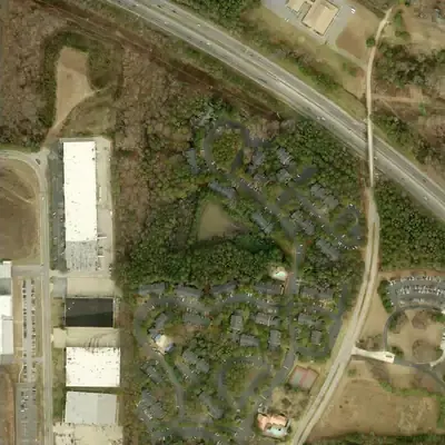
Timber Trace Lake, full in 2012
A small triangular lake, about 0.7 acres and up to 6 feet deep, held back by a tall earth dam on its west side. Built in the late 1980s or early 1990s, it was full in 2012.
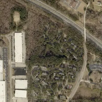
Today: The lake is gone. Since about 2017 the basin has been dry ground with grass, scrub and trees, still ringed by the dam and the apartment grounds.
- Area
- 0.7 acres
- Deepest
- about 6 ft
- Method
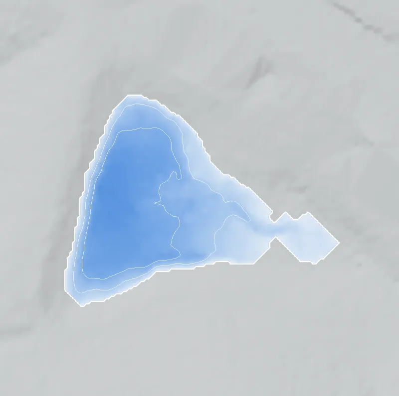
- Refilled from lidar
- Checked against
- 2012 aerial
The old lakebed is still in the ground. The water was put back in the county’s lidar up to the old shoreline, with any broken dam patched, and checked against the 2012 aerial photo. Lidar was flown when the lake was empty, so the water level is estimated and depths are minimums. The drain happened between 2013 and 2017; no photos exist for those years. How Watermarks work.
From the air
Timber Trace Lake is dry. It held water in 2012 and 2013, but by the winter of 2017 the whole basin was bare mud. It has not refilled, and the dam is still intact.
- First seen
- Not there in 1981, when the site was woods. A basin with a mowed dam strip appears in 1993, and clear water shows by 2001.
- Gone
- Dry by the winter 2017 photo. It probably drained between 2013 and 2017, but no photos exist for 2014-2016.
- Dam in the lidar
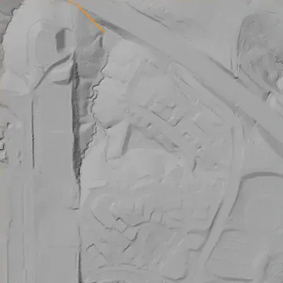
- An earth dam on the west side, about 40 ft high at its tallest near the north end and tapering to about 20 ft at the south. The clear crest is about 260 ft long and sits about 7 ft above the old pool. It is unbroken, with no breach and no notch.
- Depth from the lidar
- The county's 2024 lidar caught the lake empty. It suggests a pool level near 1,017 ft, with a maximum depth of at least 6 ft and about 2 acre-feet of water. These are minimums: silt may have raised the floor, and the normal water level could have been 1-2 ft lower.
Low water and drawdowns
- Between 2013 and 2017 (exact date unknown): A full pool in 2012 and dark water in 2013 gave way to bare mud in winter 2017. Every later photo stays empty, so this was a full drain, not a temporary drawdown.
Read from aerial photos taken between 1940 and 2026 and from DeKalb County 2024 lidar, then checked by a second reading. How the photos were read.
History
Timber Trace Lake is a small impoundment near Gladeview Parkway, at the head of a chain of three lakes in the Stone Mountain Creek watershed. NID lists a 40-foot earth dam, 370 feet long, completed in 1988, with about 15 acre-feet of normal storage over roughly 1 acre. Its owner of record is a limited partnership, not a homeowners' group, and the designer is listed as 'Hill Fister'. Georgia rates the dam Category II. NID records no inspection date. No news, plat or contract records turned up, so the 1988 date is unverified. 12345
Who built it
NID gives 1988 as the completion year and 'HILL FISTER' as the designer. Whether that is a person or firm, and whether 1988 is a completion date or an estimate, is not stated. The purpose is listed as recreation. NHDPlus places it at the top of the three-lake chain on the Stone Mountain Creek system, though the NID stream field says 'Unknown'. 135
Timeline
- 1988Completion year given in the National Inventory of Dams. NID completion years are often estimates, so this is unconfirmed. Uncertain 1
- April 20, 2021NID record last updated. It lists hazard Low, condition 'Not Rated' and no inspection date. 1
- June 4, 2025Georgia EPD's dam inventory lists Timber Trace Lake Dam as Category II, 40 ft high with 29 acre-ft maximum storage. 26
Names
The dam
Earth dam, 40 ft high (29 ft hydraulic height), 370 ft long, with 15 acre-ft normal and 29 acre-ft maximum storage over about 1 acre. Uncontrolled spillway and outlet. NID hazard Low, condition 'Not Rated'; Georgia lists it as Category II. NID shows no last-inspection date and a 5-year inspection frequency, and the NID record was last updated April 20, 2021. Owner of record in NID and the EPD inventory is a limited partnership (a private company); EPD notes its owner names come from county tax records and may be out of date. No rebuilds or contracts found. 126
- Year in the inventory
- 1988
- Dam height
- 40 ft
- Surface
- 1 acres
- Average depth
- about 15 ft
- Owner type
- Private
Figures from the U.S. Army Corps of Engineers’ National Inventory of Dams. Its “year” is often a rebuild or survey date, and average depth is storage divided by area.
Around the lake
Water
NHDPlus tracing shows this is the uppermost of the three bundle lakes: its downstream path passes the Silver Ridge lake (about 2 km east-northeast in straight line) and then Kristina Lake. USGS watershed data place all three in the Stone Mountain Creek subwatershed (HUC-12 030701030306) of the Upper Yellow River, Upper Ocmulgee basin. No named stream appears in the NHD within 2 km of the dam, so the local channel is an unnamed headwater. The snap is approximate; treat it as likely.
Visiting
Getting there
Private (NID owner type 'Private', owned by a limited partnership). No public access is documented.
What you can see
Nothing documented for visitors. The dam is near Gladeview Parkway, but I could not confirm any public viewpoint.
Look, don’t dig. Parks, cemeteries and preserves are off limits to digging and collecting, and private land needs the owner’s permission to enter.
Open questions
- Was the lake dug in 1988 or older? NID's completion year may be a guess.
- What does 'Hill Fister' refer to (an engineer, a firm), and is there a permit or design file with Georgia EPD?
- Was the lake built for an apartment or townhome complex (the owner is a limited partnership) or for a subdivision? The record does not say.
- Which parcel and plat contain the dam, and when was it platted?
Know something? Write to hello@historyunderfoot.org. Family papers, photos and deeds often settle these.
Where to look next
- Georgia EPD Safe Dams file for state ID 044-103-04480 (design by 'Hill Fister', 1988 permit or plans, inspection reports); open records request (Georgia EPD Safe Dams Program)
- DeKalb County plats and site-plan approvals for the Gladeview Parkway area, especially the Stone Mill Run and Brook Hollow developments (DeKalb County Clerk of Superior Court and DeKalb Planning and Development)
- USGS Stone Mountain 7.5-minute quadrangles (1956, 1992, 1997): does the lake appear in 1992 but not 1956? (USGS TopoView / The National Map historical topo collection)
- 1930s-40s aerial photographs of DeKalb County for the pre-suburban headwater (availability for DeKalb not verified; check UGA Libraries Map and Government Information and USGS EarthExplorer) (University of Georgia Libraries / USGS EarthExplorer)
Sources
- National Inventory of Dams: records GA03912, GA03926, GA03929, GA03930 (national CSV download, data updated 2026-09-23) U.S. Army Corps of Engineers
- Georgia Dam Inventory, updated June 4, 2025 (Excel) Georgia EPD, Safe Dams Program
- Network Linked Data Index (NHDPlus downstream navigation) USGS
- OpenStreetMap Nominatim geocoder (reverse and place search, incl. Stone Mountain Park outline) OpenStreetMap contributors
- Watershed Boundary Dataset MapServer (HUC-8, HUC-10, HUC-12 layers) USGS
- Safe Dams Program (Category I/II definitions, regulation thresholds) Georgia EPD