Still here · DeKalb County · Dam inventory GA03928
Water's Edge Lake
Private 117-acre HOA lake off Rockbridge Road; SEC filings place the dam before September 1987, and the EPA later faulted it.
From the air
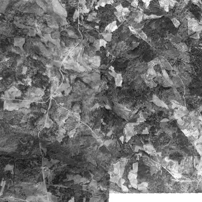
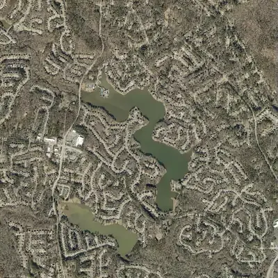
Water's Edge Lake appeared between 1981 and 1993, and no sampled aerial since 1993 shows it drawn down. In 1981 the valley was forest; by 1993 it held a full lake.
- First seen
- Absent in 1981 and a full lake with houses on three sides in 1993, so it was built in between; the photos cannot narrow it further.
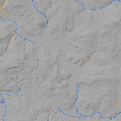
- Dam in the lidar
- An earth dam about 25 to 31 feet high and roughly 475 feet long, running north-south along the east side of the south arm. Its crest is level at about 780 feet, roughly 9 feet above the lake. There is no breach. A concrete spillway chute sits at the dam's northeast corner.
Read from aerial photos taken between 1940 and 2026 and from DeKalb County 2024 lidar, then checked by a second reading. How the photos were read.
Depth
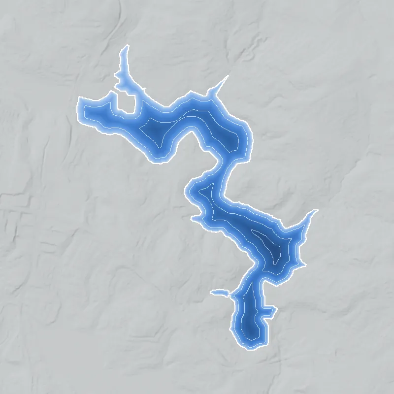
Modeled from the shoreline shape and the dam inventory’s average depth: deepest point about 18 ft. Treat it as an estimate; no survey of the lake bottom was found. How depth is estimated.
History
Water's Edge Lake is a private lake of about 117 acres beside Rockbridge Road near Stone Mountain, held through the Waters Edge Homeowners Association. It dams Stone Mountain Creek, which the National Inventory of Dams calls Mountain Creek. The 1956 USGS map shows farmland and no lake. Arvida/JMB Partners, which bought Arvida Corporation's assets from Disney on September 10, 1987, developed the Water's Edge community; its SEC filings say the dam was built while the Disney-owned seller held the land and that the EPA said it filled wetlands. The NID lists a 29-foot earth dam, rated Satisfactory on January 7, 2021. 12345
Who built it
Built before September 10, 1987, as the centerpiece of a lakeside subdivision. Arvida/JMB Partners' annual report for 1993 (filed March 31, 1994) says the EPA asserted that a dam built to create a lake at its Water's Edge community 'during the time the property was owned by the Seller' violated Section 404 of the Clean Water Act because wetlands were filled. The Seller was Arvida Corporation, a Disney subsidiary, and the Partnership acquired its assets on September 10, 1987, so the dam predates that day. The filing does not say who designed or built the dam; the NID names Waldon/Ashworth as designer. The NID gives 1988 as the completion year, which conflicts with this; the 1992 USGS quad, revised from 1988 aerials, only shows the lake existed by then. The SEC filings say 'Atlanta area'; that this is the DeKalb community is inferred from DeKalb parcel records that show Arvida/JMB holding Water's Edge parcels (Units 9 and 10) and from its listing as NID co-owner. Nothing on the 1956 map suggests an earlier mill or farm pond on the site. 31642
Timeline
- November 16, 1864 (inferred)After camping near Stone Mountain, Sherman's XX Corps marched east on the Rock Bridge road toward its Yellow River crossing at Rock Bridge. Likely today's Rockbridge Road, just south of this future lake. Likely 89
- 1955-1956USGS Snellville quad (aerials 1955, field check 1956) shows the creek valley with no lake: a few houses, Rock Bridge road, Smith Cemetery, and Macedonia Church with a cemetery beside the road. 2
- Before September 10, 1987Lake and dam built while Arvida Corporation, a Disney subsidiary, owned the Water's Edge land. Arvida/JMB's 1993 SEC filing says the EPA later claimed the dam filled wetlands, violating Clean Water Act Section 404. Likely 3
- September 10, 1987Arvida/JMB Partners buys substantially all assets of Arvida Corporation from Disney's subsidiary. By 1994 it reports owning Water's Edge near Atlanta, with third-party builders building the homes. 310
- 1988 aerials; 1992 quadUSGS revises the Snellville quad from 1988 aerials (field checked 1991). It draws the finished lake and built-up streets on the northeast side. The NID lists 1988 completion, though SEC filings imply an earlier dam. 613
- 1992-1995Arvida/JMB writes down Water's Edge and Dockside inventory: $7.4 million in 1992 and $4.9 million more in 1993, after slow sales. Its 1995 filing still reports weak demand in this Atlanta sub-market. 310
- By March 31, 1994Arvida/JMB reports an EPA consent agreement over the lake's dam: it bought land (about $400,000) for wetlands mitigation, and EPA agreed in principle to a $125,000 civil penalty. The partnership sought indemnification from Disney. 3
- 1996Water's Edge closings rise as several new housing products introduced in 1995 have their first closings, according to Arvida/JMB's annual report for 1996. 11
- c. 1988-1999 (recording dates not checked)Water's Edge, Harbor Pointe at Water's Edge, The Hills of Water's Edge and Forest Cove are platted in units around the lake, plat books 85 to 115; the county GIS layer gives no recording dates. Uncertain 12
- 1999USGS Snellville quad edition (planimetry from 1999 imagery) shows dense street patterns on the north, east and south shores, so the neighborhoods were largely laid out by then. 13
- December 1999 - March 6, 2000Arvida/JMB records a $1 million impairment on Water's Edge and contracts on March 6, 2000 to sell about 103 remaining lots and the sales center to an unaffiliated builder for about $3.2 million. 14
- March-December 2000The bulk sale closes in three phases: 29 lots in March, 51 lots plus the sales center in September, and 23 lots in December 2000, for about $3.2 million in all. 15
- January 7, 2021Georgia Safe Dams inspection rates the dam Satisfactory. The NID lists it as High hazard, a measure of downstream consequences rather than condition; NID record updated April 20, 2021. 1
Names
- Water's Edge Lake Dam
- Dam name in the National Inventory of Dams; the NID owner field reads 'Waters Edge Homeowners Association' and 'Arvida/JMB Partners L P'. 1
- WATERS EDGE LAKE
- Label on the DeKalb County GIS water-body polygon (surface elevation 769 ft); the polygon lies within about 15 m of the NID dam point. 16
- Stone Mountain Creek (impounded stream; NID says 'Mountain Creek')
- The NID gives the stream as Mountain Creek. The official name in the USGS Geographic Names database is Stone Mountain Creek (DeKalb County, mouth at the Yellow River), and the DeKalb GIS and USGS 3DHP flowlines at the lake use that name. The USGS quads letter 'Stone', 'Mountain' and 'Creek' in separate pieces along the stream, so 'Mountain Creek' looks like a truncation. 1161756
- Water's Edge / Harbor Pointe at Water's Edge / The Hills of Water's Edge / Forest Cove at Water's Edge
- Subdivision names on DeKalb plats around the lake: Water's Edge Units 2 to 10 (including 8A and 8B), Harbor Pointe at Water's Edge Units 1 to 8, The Hills of Water's Edge (with a Phase 3), and Forest Cove at Water's Edge (with a Phase 2). 12
The dam
Earth dam, 29 ft high (28 ft hydraulic height), 500 ft long, impounding Stone Mountain Creek (NID: Mountain Creek). Normal storage 811 acre-ft, maximum 1,787 acre-ft, 117 surface acres. Spillway and outlet are listed as uncontrolled. High hazard potential; condition Satisfactory at the state inspection of January 7, 2021, with a two-year inspection frequency and an emergency action plan prepared. NID record last updated April 20, 2021. Georgia Safe Dams ID 044-101-04422. The NID shows no rebuilds, drawdowns or repairs, and title searches of DeKalb County's Legistar found no items on this dam, which fits HOA ownership. The one documented dam problem is regulatory: Arvida/JMB's 1993 annual report describes an EPA consent agreement over wetlands filled for the dam, with about $400,000 of land bought for mitigation and an agreement in principle on a $125,000 civil penalty. The NID drainage-area figure (11,942 sq mi) is clearly a unit error. 173
- Year in the inventory
- 1988
- Dam height
- 29 ft
- Surface
- 117 acres
- Average depth
- about 6.9 ft
- Stream
- Mountain Creek
- Owner type
- Private
Figures from the U.S. Army Corps of Engineers’ National Inventory of Dams. Its “year” is often a rebuild or survey date, and average depth is storage divided by area.
Around the lake
Water
Impounds Stone Mountain Creek (NID: Mountain Creek), which flows east to the Yellow River; the USGS names database puts the creek's mouth at 33.7687, -84.0627, where the 1992 quad shows the Yellow River. Crooked Creek Lake (GA03927, 55 acres, NID year 1987, county-owned, designer spelled Walden-Ashworth) lies about 0.7 km southwest.
Civil War
Georgia marker 044-87 (reported missing in 2022) says the XX Corps took the Rock Bridge road from Decatur, camped near Stone Mountain, and next morning continued on the Rock Bridge road, crossing the Yellow River at Rock Bridge 8 miles east. That road is likely today's Rockbridge Road, about 180 m from the dam point. No lines or camps are documented at the lake itself.
Before 1861
The 1956 map prints land-lot numbers of the 18th District over the lake site (the lake spans lots 26, 27, 29 and 30), with Rock Bridge road, Smith Cemetery and Macedonia Church nearby, but no pre-1860 mill or road tied to the valley has been found.
Visiting
Getting there
Private. The Waters Edge Homeowners Association holds the roughly 129.7-acre lake parcel (7091 Waters Edge Drive per county tax records, last edited 2018) and many common-area parcels; the NID owner type is Private. No public park, boat launch or trail was found. Rockbridge Road runs about 180 m from the dam point.
What you can see
Rockbridge Road and North Deshon Road are public county roads near the lake. Whether the water or dam can be seen from the public right-of-way is unverified. There are no known markers or ruins; the lake and dam are inside private property, so do not enter.
Look, don’t dig. Parks, cemeteries and preserves are off limits to digging and collecting, and private land needs the owner’s permission to enter.
Open questions
- Who designed and built the dam, and exactly when? SEC filings place it before September 10, 1987; the NID says 1988. The Georgia Safe Dams permit file or the EPA consent order would settle it.
- Is the 'Water's Edge' in the SEC filings this DeKalb community? The link rests on DeKalb parcel records showing Arvida/JMB holding Water's Edge parcels; the filings say only 'Atlanta area'.
- What were the final terms of the EPA consent agreement and penalty? The 1994 filing reports only an agreement in principle.
- When were the plats recorded? Plat books run from 85 to 115, but the county GIS layer gives no dates, so the build-out timing rests on topo editions and SEC sales reports.
- Has the dam been inspected since January 2021? The NID entry has not been updated since April 20, 2021.
- Surface area varies: NID 117 acres, USGS 3DHP about 122 acres, HOA lake parcel 129.72 acres.
- Who holds the Arvida/JMB parcels now? Arvida/JMB Partners' SEC registration later became ALP Liquidating Trust, but the county parcel data still shows the Arvida/JMB name (last edited 2018).
- How do Smith Cemetery and Macedonia Church with its cemetery, both shown in 1956, relate to earlier settlement and land ownership?
Know something? Write to hello@historyunderfoot.org. Family papers, photos and deeds often settle these.
Where to look next
- DeKalb Superior Court plat books: The Hills of Water's Edge PB 85 p.86; Water's Edge Unit 3 PB 88 p.35; Unit 4 PB 89 pp.75-76; Harbor Pointe Unit 1 PB 94 pp.4-5; Water's Edge Unit 6 PB 102 pp.13 and 16; Unit 10 PB 115 pp.104-109. Recording dates will date the build-out. (DeKalb County Clerk of Superior Court, plat records; references from the DeKalb GIS subdivision layer)
- Georgia Safe Dams file 044-101-04422: permit application, Waldon/Ashworth design drawings, construction certification and inspection reports, requested through the state open-records process. (Georgia EPD Safe Dams Program)
- EPA Region 4 Clean Water Act Section 404 consent agreement and order with Arvida/JMB Partners over the Water's Edge dam (c. 1992-1994), described in the partnership's 1993 annual report; the docket would give dates, acreage of wetlands filled and the final penalty. (EPA Region 4 (Atlanta) enforcement records, by public records request)
- Arvida/JMB Partners annual reports (Form 10-K) for 1993 through 2000, which carry the Water's Edge sales, write-down and EPA passages. The partnership's 1987 offering prospectus (Form S-1 No. 33-14091) predates EDGAR and may describe the Atlanta land. (SEC EDGAR, CIK 0000814046 (later ALP Liquidating Trust))
- The Champion (Decatur) pages from November 2015 to February 2016 match 'Water's Edge' and 'Arvida' in the Georgia Historic Newspapers search; their text could not be read here and may be legal notices. (Georgia Historic Newspapers, Digital Library of Georgia)
- USGS 1:24,000 Snellville quads for 1956, 1992 and 1999; the TNM listing shows no other 1:24,000 editions at this point. The 1981 Atlanta 1:100,000 sheet could show whether the lake existed then. (USGS Historical Topographic Map Collection)
- Historic aerials of the valley, especially the earliest DeKalb coverage from UGA (1938-40) and any mid-1980s aerials, to see the creek valley before and during construction. (UGA Libraries map collections; DeKalb County GIS)
- 1980s DeKalb rezoning files and Board of Commissioners minutes for the Water's Edge development (zoning now RSM), plus Atlanta Journal-Constitution real-estate coverage of the community. (DeKalb County Planning and Development; newspaper archives)
- Smith Cemetery and Macedonia Church with its cemetery, shown on the 1956 quad, for local settlement history. (DeKalb History Center; DeKalb County cemetery records)
Sources
- National Inventory of Dams, record GA03928 Water's Edge Lake Dam (national CSV, data updated 2026-9-23; dam record updated 04/20/2021) U.S. Army Corps of Engineers
- USGS 1:24,000 Snellville, GA quadrangle, 1956 (aerials 1955, field check 1956) U.S. Geological Survey
- Arvida/JMB Partners, L.P., Form 10-K for 1993 (filed March 31, 1994): Items 1-3, EPA proceeding, 1992-93 write-downs U.S. Securities and Exchange Commission (EDGAR)
- DeKalb County GIS, Tax Parcels layer (HOA and Arvida/JMB parcel records, last edited 2018) DeKalb County, GA
- USGS Geographic Names Information System, Stone Mountain Creek (DeKalb County, feature ID 326089) U.S. Geological Survey, Board on Geographic Names
- USGS 1:24,000 Snellville, GA quadrangle, 1992 (revised from 1988 aerials, field checked 1991) U.S. Geological Survey
- DeKalb County Legistar Web API (matter title searches; no items on this dam) DeKalb County Board of Commissioners
- Historical marker 044-87, 'The March to the Sea' (Stone Mountain; reported missing 2022), inscription transcription Historical Marker Database (Georgia Historical Commission marker text)
- Historical marker 044-85, 'The March to the Sea' (near Lithonia), inscription transcription Historical Marker Database (Georgia Historical Commission marker text)
- Arvida/JMB Partners, L.P., Form 10-K405 for 1994 (filed March 30, 1995) U.S. Securities and Exchange Commission (EDGAR)
- Arvida/JMB Partners, L.P., Form 10-K405 for 1996 (filed March 31, 1997) U.S. Securities and Exchange Commission (EDGAR)
- DeKalb County GIS, Subdivision polygons with plat book and page (DeKalb_Subdivisions layer) DeKalb County, GA
- USGS 1:24,000 Snellville, GA quadrangle, 1999 (planimetry from 1999 imagery) U.S. Geological Survey
- Arvida/JMB Partners, L.P., Form 10-K for 1999 (filed March 30, 2000): Water's Edge impairment and bulk lot sale contract U.S. Securities and Exchange Commission (EDGAR)
- Arvida/JMB Partners, L.P., Form 10-K for 2000 (filed March 30, 2001): closings of the Water's Edge bulk sale U.S. Securities and Exchange Commission (EDGAR)
- DeKalb County GIS, Water Bodies layer (WATERS EDGE LAKE polygon; STONE MOUNTAIN CREEK stream) DeKalb County, GA
- USGS 3D Hydrography Program (3DHP) waterbodies and flowlines U.S. Geological Survey