Still here · Fulton County · Dam inventory GA01896
Wildwood Lake
Ten-acre private lake in southwest Atlanta, already on the 1954 topographic map among woods and dirt roads; houses lined its shore by 1982.
From the air
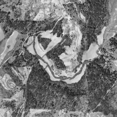
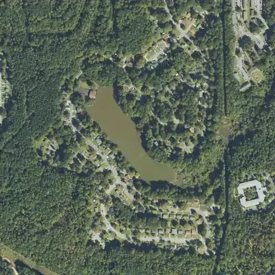
In 1940 this was a farmed creek valley with a dirt road crossing the creek. By 1955 the lake was full, its dam built just upstream of that crossing.
- First seen
- Not in the 1940 aerial; full in the 1955 aerial, so it was built between those years.
- Dam in the lidar
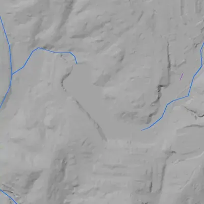
- A curved earth dam at the north-northwest end, about 210 to 220 feet long. Its flat crest is about 4 feet above the lake. It is about 8 feet high on its face and about 16 feet above the outlet channel below. No breach. A spillway swale probably runs around the west end.
Read from aerial photos taken between 1940 and 2026 and from USGS 3DEP lidar, then checked by a second reading. How the photos were read.
Depth
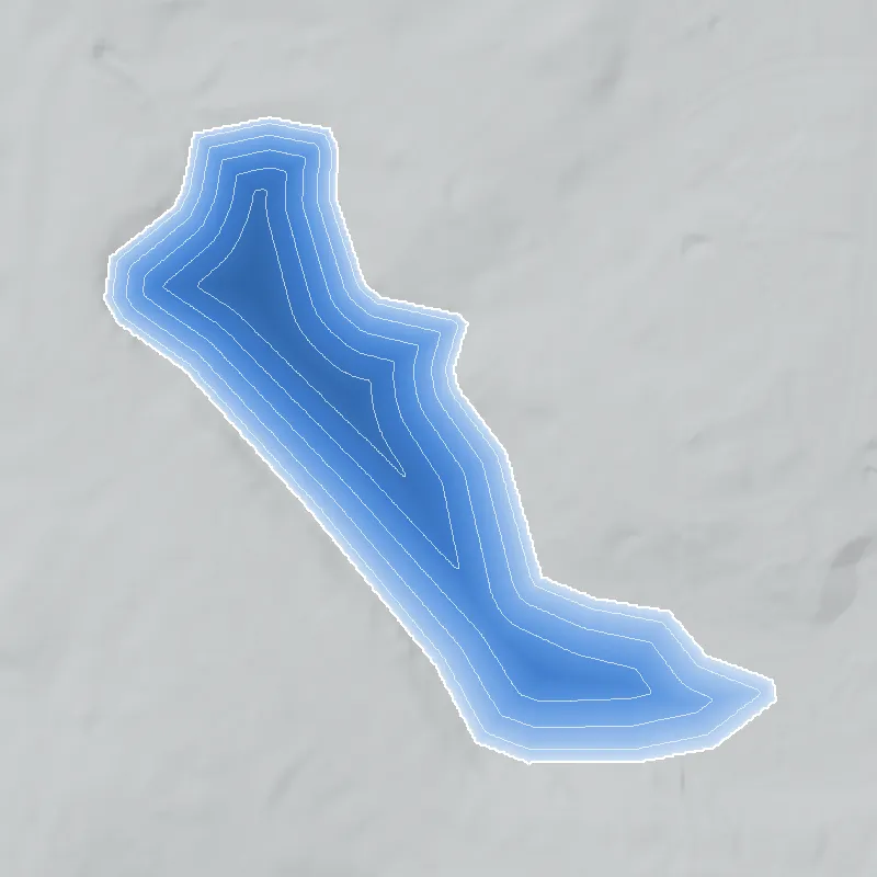
Modeled from the shoreline shape and the dam inventory’s average depth: deepest point about 12 ft. Treat it as an estimate; no survey of the lake bottom was found. How depth is estimated.
History
Wildwood Lake is a roughly 10-acre private lake in southwest Atlanta's Wildwood neighborhood (NPU-H), held by a 15-foot earthen dam. It is older than the houses around it: the 1954 USGS map, compiled from 1952 aerial photos and field-checked in 1954, already labels it 'Wildwood Lake' among woods and dirt roads. Roads and scattered houses appear in the 1968 map revision, multi-unit buildings to the northeast by 1973, and houses line the shore by 1982. The National Inventory of Dams lists a company and a homeowners association as owners, with recreation as the use. Who built the dam, and when, is not in any source reached. 1234567
Who built it
The builder, date and original purpose are not documented in any source reached. The 1954 USGS Ben Hill map (aerial photographs taken 1952, field check 1954) prints the lake and a dam line across its north-northwest end, with woods, a few buildings and unimproved roads around it. The map does not say whether the lake was drawn from the 1952 photos or added at the 1954 field check, so it existed by 1954 and probably by 1952. NID gives 'Recreation' as the purpose, designer 'Unknown' and year completed 'Undetermined'. USGS hydrography shows the lake on a small unnamed stream in a catchment of about 0.9 sq mi that drains to Utoy Creek and on to the Chattahoochee. The name 'Wildwood Lake' is on the 1954 map, so it predates the subdivision. 189210
Timeline
- 1952Aerial photographs taken for the USGS Ben Hill quadrangle. The lake was probably already there, but the map does not say whether it was drawn from these photos or added at the 1954 field check. Likely 2
- 1954USGS Ben Hill 7.5-minute map (field checked 1954) prints 'Wildwood Lake' in Land Lot 26, with a dam line at its north-northwest end, amid woods, a few buildings and unimproved roads. No subdivision streets yet. 2
- 1968Photorevised Ben Hill map (revisions from 1968 aerial photos, not field checked) adds roads and scattered houses on the north and northwest sides of the lake. 3
- 1971'Site 45: Wildwood Lake Estates' appears on a Joint Committee map of proposed public-housing sites (Planning Atlanta collection, GSU). The catalog record does not give a usable location, so the link to this lake is unconfirmed. Uncertain 1213
- 1972-1987A neighborhood listing site gives 1972 to 1987 as the build years of homes in Wildwood Lake Estates, consistent with the map record. Commercial listing data, not a county record. Likely 7
- 1973Ben Hill map revised again (1968 and 1973 photos) adds multi-unit building footprints northeast of the lake toward Fairburn Road and more houses north and northwest of it; the lake outline is unchanged. 4
- 1982Map edition revised from 1981 aerials shows houses along streets on the north, west and south sides of the lake. 5
- July 1, 1984Last inspection date recorded for the dam in the National Inventory of Dams. 1
- 1999USGS edition (planimetry from 1999 imagery) shows streets and houses on most sides of the lake; its contours still derive from the 1952 photos. 14
- April 20, 2021Most recent update of the NID record: low hazard, not rated, owners listed as Tharpe & Brooks, Inc. (spelled 'Thorpe' in NID) and a homeowners association. 1
Names
- Wildwood Lake Dam
- Name of the structure in the National Inventory of Dams; state ID 060-033-00677. NID gives the stream as 'Unknown'. 1
- Wildwood Lake (GNIS 325294)
- Federal hydrography name for the roughly 10-acre waterbody; the same name is printed on the 1954, 1968, 1973, 1982 and 1999 USGS Ben Hill quadrangles. 8234514
- Wildwood Lake Estates
- Name on a 1971 City of Atlanta public-housing-site map ('Site 45') and on a neighborhood listing site that dates its homes to 1972-1987. Wildwood Lake Dr runs around this lake, so the subdivision is very likely this one, but the 1971 map's location could not be confirmed. 12715
- Wildwood Lakes Homeowners Association, Inc / Wildwood Lake HOA
- Co-owner of the dam in the NID (spelled 'Lakes' there). A 'Wildwood Lake HOA' website describes 'a residential community built around the lake'; it says nothing about the lake's history or dam. 116
- Wildwood (NPU-H)
- The City of Atlanta's official neighborhood polygon (about 179 acres) that contains the lake. 6
The dam
NID: earth dam, 15 ft high (14 ft structural and hydraulic), 213 ft long, uncontrolled spillway and outlet, 10.1 surface acres, 56 acre-ft normal and 89 acre-ft maximum storage. Hazard class Low, condition Not Rated, Emergency Action Plan not required. NID marks it not state-regulated, consistent with Georgia's Safe Dams Act, which covers dams 25 ft or higher or holding 100 acre-ft or more and, of those, regulates only high-hazard Category I dams. Last inspection date in NID is July 1, 1984; the record was last updated April 20, 2021. NID's drainage area of '275 sq mi' cannot be right; the USGS NHDPlus basin outline gives about 0.9 sq mi. No rebuild, repair or public contract for this private dam was found. 1911
- Dam height
- 15 ft
- Surface
- 10.1 acres
- Average depth
- about 5.5 ft
- Owner type
- Private
Figures from the U.S. Army Corps of Engineers’ National Inventory of Dams. Its “year” is often a rebuild or survey date, and average depth is storage divided by area.
Around the lake
Water
The lake impounds a small unnamed stream on the upland northeast of Utoy Creek; the outflow reaches Utoy Creek a short distance to the west, and Utoy Creek flows to the Chattahoochee. The USGS/NHDPlus basin outline above the dam is about 0.9 sq mi. (Sources: 2, 3, 20.)
Civil War
Nearby, not on site. The 1958 Georgia Historical Society marker 'Enroute to Jonesboro' (Fairburn Road, north of Cascade Road) records that on Aug 26, 1864 the Federal Army of the Tennessee camped 'on and near' the Wilson plantation, with Gen. John A. Logan's headquarters at Judge William A. Wilson's residence. The Wilson house stood in the 500 block of Fairburn Road, roughly 0.4 mile east of the lake by the map, and was reduced to rubble by January 2016 (AJC). The Battle of Utoy Creek (Aug 5 to 7, 1864) was fought along Utoy Creek and the Sandtown (Cascade) Road corridor in the same general area southwest of the lake; the exact distance is not established (Wikipedia, likely). (Sources: 13, 14, 22.)
Segregation
No source reached says whether Wildwood Lake had a whites-only or Black-owned club or beach era. Context only: a 1967 WSB-TV newsfilm record is titled 'Attempt at stabilizing racial mix in southwest Atlanta by stopping unethical realtors', and a 'Wildwood Lake Estates' site appears on the 1971 public-housing siting maps, though its location is unconfirmed. (Sources: 11, 12.)
Before 1861
The lake is in Land Lot 26 of the 14th District of Fulton County (parcel ID 14F0026). The first grantee and any farm or mill use are not established. The 1954 map shows only unimproved dirt roads and a few buildings on the site, with no mill or millpond marked. Utoy Creek's name is most likely from the Utoy Indians (Wikipedia, likely). (Sources: 4, 9, 20.)
Visiting
Getting there
Private. NID lists the owners as a private company and a homeowners association, and the HOA runs a community website for a residential community around the lake. The lake is inside a neighborhood served by Plainville Dr, Willow Cove Way and Wildwood Lake Dr SW. No public park, boat launch or public access is documented. Not verified on the ground. (Sources: 1, 9, 16, 19.)
What you can see
Unverified. From the map record: a roughly 10-acre lake with an earth dam about 213 ft long at its north-northwest end, with houses on most sides. Any view is likely limited to public streets where they touch the shore. No historical marker or ruin is known. Tatum Lake, a separate lake about 0.6 mile north-northwest, appears on the same maps and is not Wildwood Lake. (Sources: 1, 4, 8.)
Look, don’t dig. Parks, cemeteries and preserves are off limits to digging and collecting, and private land needs the owner’s permission to enter.
Open questions
- Who built the dam and lake before 1954, and for what purpose (farm pond, fishing lake, club, or a developer's amenity)?
- When did Tharpe & Brooks, Inc. acquire the lake and dam, and when were the subdivision plats recorded (Fulton plat books, Land Lot 26, 14th District)?
- Is the 1971 'Site 45: Wildwood Lake Estates' public-housing site on this lake? The DLG record's coordinates are a generic downtown Atlanta point.
- Was the lake ever run as a swim or fishing club, and under what racial policy?
- What was the 1984 NID inspection and has the dam been repaired since? NID's drainage-area figure (275 sq mi) is obviously wrong.
- Why is the HOA named 'Wildwood Lakes' (plural) in NID but 'Wildwood Lake' everywhere else?
Know something? Write to hello@historyunderfoot.org. Family papers, photos and deeds often settle these.
Where to look next
- Fulton County 1938 ASCS aerial photography index (18 sheets, 1:20,000). Use it to find frames covering Land Lot 26, 14th District, which would show whether the lake existed before 1940. This is an index; frames may need to be requested. (Digital Library of Georgia / UGA Map and Government Information Library, Georgia aerial photography indexes)
- Later Fulton County aerial photography indexes (1949-1950, 1955) that could locate frames between the lake's first map appearance and the subdivision. (Digital Library of Georgia / UGA Map and Government Information Library, Georgia aerial photography indexes)
- USGS Ben Hill quad editions (1954, 1968, 1968 and 1973, 1982, 1999; two further scans are reprints of the 1954 and 1982 sheets). The 1954 edition is the earliest evidence of the lake. Compare shorelines and road growth. (USGS Historical Topographic Map Collection)
- 1971 'Site 45: Wildwood Lake Estates' map and the 'Southwest Ben Hill' general-areas map (report atlpp0293). Open the images to read the service map and confirm the location. (GSU Planning Atlanta collection)
- Subdivision plats for Wildwood Lake or Wildwood Lake Estates and deed history for the dam parcel (14F0026 LL0279). This should show when Tharpe & Brooks, Inc. took title and who owned the land before. (Fulton County Clerk of Superior Court, plat books and real-estate records)
- Atlanta Constitution, Atlanta Journal and Atlanta Daily World real-estate ads and news, 1950s to 1970s, searching 'Wildwood Lake' and 'Tharpe & Brooks'. Not searchable through the tools used here. (Atlanta-Fulton Public Library newspaper databases; Atlanta History Center Kenneth Rogers and Lane Brothers photo collections)
- 1967 WSB-TV newsfilm on racial change and realtors in southwest Atlanta, for neighborhood context. (Walter J. Brown Media Archives, WSB-TV Newsfilm Collection)
- Original grantee of Land Lot 26, 14th District, from the land-lot survey and lottery records. This supports the Early theme. (Georgia Archives, Surveyor General land-lot records)
Sources
- National Inventory of Dams, national CSV, record GA01896 (Wildwood Lake Dam), data updated 2026-09-23 U.S. Army Corps of Engineers
- USGS 1:24,000 Ben Hill, GA, 1954 edition (aerial photos 1952, field checked 1954) U.S. Geological Survey, Historical Topographic Map Collection
- USGS 1:24,000 Ben Hill, GA, 1954, photorevised 1968 (revisions from 1968 aerial photographs, not field checked) U.S. Geological Survey, Historical Topographic Map Collection
- USGS 1:24,000 Ben Hill, GA, 1954, photorevised 1968 and 1973 U.S. Geological Survey, Historical Topographic Map Collection
- USGS 1:24,000 Ben Hill, GA, 1954, photorevised 1982 (revisions from 1981 aerial photographs) U.S. Geological Survey, Historical Topographic Map Collection
- City of Atlanta 2020 Neighborhoods layer: Wildwood (NPU-H) City of Atlanta, Department of City Planning
- Wildwood Lake Estates, Atlanta, GA neighborhood listing (homes built 1972-1987) neighborhoods.com
- USGS 3D Hydrography Program (3DHP) waterbody and flowline layers: Wildwood Lake, GNIS 325294 U.S. Geological Survey
- USGS NLDI: NHDPlus comid 3286406 downstream navigation (toward Utoy Creek and the Chattahoochee) and upstream basin outline (about 0.9 sq mi) U.S. Geological Survey
- Utoy Creek (Wikipedia; tributary of the Chattahoochee; name most likely from the Utoy Indians) Wikipedia
- Safe Dams Program Frequently Asked Questions (FAQ): dams under the Act are 25 ft or higher or 100 acre-ft or more; only Category I dams regulated Georgia Environmental Protection Division
- Site 45: Wildwood Lake Estates (1971), Joint Committee for the Selection of Public Housing Sites, Planning Atlanta collection (catalog record only; image not opened) Georgia State University Library / Digital Library of Georgia
- Southwest Ben Hill: proposed public-housing sites map (1971), Planning Atlanta collection (catalog record only) Georgia State University Library / Digital Library of Georgia
- USGS 1:24,000 Ben Hill, GA, 1999 edition (topography from 1952 photos; planimetry from 1999 imagery) U.S. Geological Survey, Historical Topographic Map Collection
- Fulton County Tax Parcels 2025 (parcel 14F0026 LL0279 at the NID point; street names around the lake) Fulton County GIS
- Wildwood Lake HOA (community website; no history or dam information) Wildwood Lake HOA