Drained · DeKalb County · Location approximate
Henderson's mill pond
Site of Greenville Henderson's grist mill on Henderson Mill Creek; no pond is mapped today, and a July 1864 Union corps camp is recorded here.
From the air
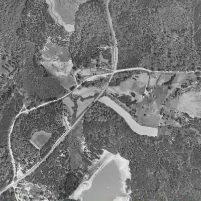
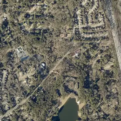
No aerial photo from 1955 to 2026 shows a pond here. The mill pond, if it existed, was gone before the earliest usable photo.
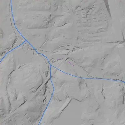
- Dam in the lidar
- Lidar found no dam. The only embankment is a narrow road or track fill across the valley, about 13 feet wide with a crest near 926 feet, roughly 7 to 9 feet above the creek. The creek probably passes through a culvert. It holds no pond and is probably road fill.
Read from aerial photos taken between 1940 and 2026 and from DeKalb County 2024 lidar, then checked by a second reading. How the photos were read.
History
Georgia Historical Commission marker 044-18 (1985) records a grist mill of the 'ante and post bellum' years, owned and operated by Greenville Henderson (1792-1869) and his son Rufus (1823-1872), about 300 ft northwest of the marker. The flat on both sides of Henderson Mill Road was the mill pond area, and the mill was demolished in 1911. On July 18, 1864, Logan's XV Corps of the Union Army of the Tennessee camped here, partly because water was short at Browning's Court House (Tucker). No pond is mapped today, and no dam record turned up in the National Inventory of Dams. 12345
Who built it
Built by or for the Henderson family; marker 044-18 says the mill was owned and operated by Greenville Henderson (1792-1869) and his son Rufus (1823-1872) in the years before and after the Civil War. No source found gives the year the mill or dam was built, or who built it. The pond impounded what USGS now calls Henderson Mill Creek. A Wikipedia list says most Atlanta-area mills date to the 1820s-1830s, which is context only and not specific to this mill. 146
Timeline
- 1792Greenville Henderson, later owner and operator of the mill, is born (birth year given on the state marker). 1
- 1823Rufus Henderson, Greenville's son and later co-operator of the mill, is born (birth year given on the state marker). 1
- Before 1864 (date not found)The Hendersons' grist mill is in operation; the marker calls it an 'ante bellum' mill and says the flat land along the road was its pond area. The construction year is not recorded in the sources found. Likely 1
- July 18, 1864Logan's XV Corps, Army of the Tennessee, withdraws about 1.5 miles west from the Browning's Court House (Tucker) area to Henderson's mill and camps for the night. Reasons given: a more compact front and water not available at Browning's. 12
- July 19, 1864Logan's troops leave the Henderson's Mill camp at 5 a.m. and march to Decatur by the roads now called Henderson Mill, LaVista, Montreal and Lawrenceville. 3
- 1869Greenville Henderson dies (dates on marker). 1
- 1872Rufus Henderson dies (dates on marker). The marker describes the mill as running in the post-war years as well. 1
- 1911The mill is demolished, according to marker 044-18. 1
- 1954The Georgia Historical Commission puts up marker 044-17 at Lavista and Midville roads, Tucker, describing the July 18 move to Henderson's mill; marker 044-20 near Briarcliff and Henderson Mill roads dates from the same year. 23
- 1985Marker 044-18, 'Site: Henderson's Mill', is erected on Henderson Mill Road. 13
Names
- Henderson's Mill (site)
- Name used by the Georgia Historical Commission markers for the mill and its camp site; the pond appears only as the 'mill pond area' on marker 044-18. 12
- Henderson Mill Creek
- USGS/GNIS name (GNIS ID 325958) for the stream in the 3DHP flowline data, whose confluence lies about 90 m west of the marker point. The road and the neighborhood take the Henderson Mill name. 4
- Henderson Creek
- Name used in Wikipedia's list of historic Atlanta-area mills, which cites a GeorgiaInfo almanac entry that could not be opened. Probably the same stream under a shorter name; not confirmed. 6
The dam
No dam record found. The National Inventory of Dams (national CSV, data updated 2026-09-23) lists no dam within about 300 m of the marker; the nearest is North Lake Dam (GA02051, 1953 per NID), 0.31 km SSW, which belongs to a different lake. I did not find a Georgia Safe Dams record, height, spillway description or contract for the mill pond. The marker describes the pond only as the flat land 'left and rt.' of Henderson Mill Road, so the dam line is undocumented. 15
Around the lake
Water
USGS 3DHP hydrography names the stream Henderson Mill Creek (GNIS 325958). Its mapped flowline flows west-northwest from a headwater about 1.6 km to the southeast, joins a small unnamed branch about 90 m west of the marker point, then continues northwest as a second-order stream. The mill site, 300 ft NW of the marker, falls close to that line. The marker and marker 044-17 say water at Browning's Court House was inadequate, which is why the corps came here. I did not confirm the downstream watershed. The 3DHP waterbody layer shows no lake polygon at the site; the nearest are North Lake (0.57 km) and Kingscliff Lake (0.81 km).
Civil War
Logan's XV Corps camped at the mill the night of July 18, 1864, after supporting Garrard's cavalry raid toward Stone Mountain from Browning's Court House. Marker 044-20 says it left at 5 a.m. on July 19 and marched to Decatur by roads now named Henderson Mill, LaVista, Montreal and Lawrenceville. The Rainey plantation marker (044-8, Shallowford and Chamblee-Tucker roads, currently listed as not in place) gives the corps's earlier route, roughly the present Chamblee-Tucker Road, to Browning's Court House.
Before 1861
An antebellum grist mill on a stream, owned by Greenville Henderson (born 1792) and continuing under his son Rufus after the war. The mill stood off what is now Henderson Mill Road, which shares its name; that the road and community took the name from the mill is likely but the sources checked do not say so directly. No land-lot number or plat found.
Visiting
Today
Road, houses and creek flat along Henderson Mill Road.
Getting there
The marker sits on Henderson Mill Road, a public road, and the former pond flat lies along both sides of it. Much of the surrounding land appears to be private residential lots; parcels were not checked, and no public park or preserve is documented here.
What you can see
The state marker (044-18) beside the road is the one confirmed thing to see. No record of standing mill ruins, a dam or a spillway was found, and none was confirmed. Stay on the public right-of-way and do not dig or cross private land; the creek flat is only visible from the road.
What to look for
The flat former pond bed on both sides of the road and any dam remnant just downstream.
Look, don’t dig. Parks, cemeteries and preserves are off limits to digging and collecting, and private land needs the owner’s permission to enter.
Open questions
- When was the mill and its dam built, and by whom? The marker only says 'ante bellum'.
- Was the pond dammed across the road line or downstream of it, and does any dam remnant survive?
- Which land lots did the Henderson tract cover, and when did the family acquire it?
- Are Greenville Henderson (1792-1869) and Rufus (1823-1872) buried locally, and what do their probate or deed records say about the mill?
- Why was the mill demolished in 1911, and did it work until then?
- Wikipedia's list places the mill 'near Lithonia' and 'one-tenth of a mile south of Midvale Road'; does the underlying GeorgiaInfo entry give different coordinates from marker 044-18?
Know something? Write to hello@historyunderfoot.org. Family papers, photos and deeds often settle these.
Where to look next
- DeKalb History Center archives (subject files, photograph files, oral history collection); a site search for 'Henderson Mill' returned only generic collection titles and no item-level hits, so ask a reference archivist. (DeKalb History Center, Decatur)
- UGA 1938-40 DeKalb County aerial photographs: check the Henderson Mill Road creek flat for a pond, dam line and mill site before suburban development. (UGA Libraries Map and Government Information Library / Digital Library of Georgia)
- USGS topographic quadrangles (Chamblee, Stone Mountain, Lithonia editions from the 1900s onward) to see whether a pond or mill symbol is drawn on Henderson Mill Creek. (USGS Historical Topographic Map Explorer)
- DeKalb County deed and probate records for Greenville Henderson (d. 1869) and Rufus Henderson (d. 1872), including estate inventories that might list mill equipment. (DeKalb County Superior and Probate Court archives / Georgia Archives)
- Georgia Historic Newspapers: search 'Henderson's Mill' and 'Henderson Mill' for 1900-1915 items on the mill's closing or demolition in 1911. (Digital Library of Georgia, Georgia Historic Newspapers)
- David Seibert's 'Henderson's Mill' entry in the GeorgiaInfo Online Georgia Almanac, cited by Wikipedia; it could not be fetched by the researcher and is readable in a browser. (GeorgiaInfo, Digital Library of Georgia)
- Official Records of the Civil War (Army of the Tennessee, July 18-19, 1864 reports for Logan's XV Corps) for the original wording on the camp. (Official Records / Cornell or HathiTrust scans)
Sources
- Site: Henderson's Mill (GHS marker 044-18, erected 1985) Georgia Historical Society / Georgia Historical Commission marker program
- Logan's Corps Moves To Henderson's Mill (GHS marker 044-17, erected 1954) Georgia Historical Society / Georgia Historical Commission marker program
- GA_Historical_Markers FeatureServer (marker text, year and coordinates for 044-17, 044-18, 044-20, 044-21 and 044-8) Georgia Historical Society / Georgia DNR (ArcGIS)
- USGS 3D Hydrography Program MapServer (Henderson Mill Creek flowlines; waterbodies including North Lake) U.S. Geological Survey
- National Inventory of Dams, national CSV download (data updated 2026-09-23) U.S. Army Corps of Engineers
- Historic mills of the Atlanta area (Henderson's Mill entry) Wikipedia