Drained · City of Atlanta · Location approximate
Lake Ponceana (linked to the name 'Lake Claire')
A dry artificial lake at Claire and Lakeshore Drives that, by neighborhood accounts, inspired the name Lakeshore Drive and perhaps 'Lake Claire'.
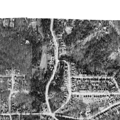
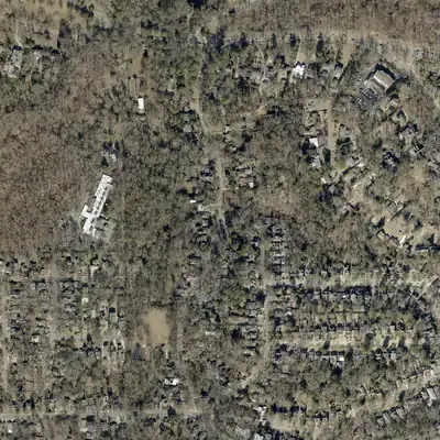
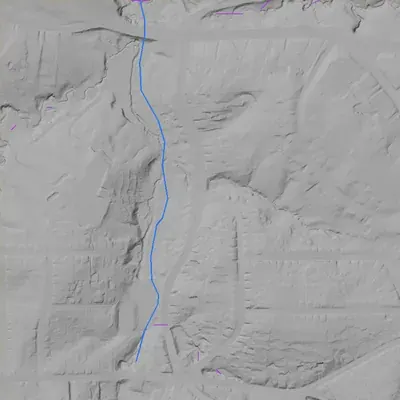
From the air
No lake shows at Claire and Lakeshore in any photo from 1940 to 2026. A pond-shaped patch about 1,000 feet north-west in 1968-72 is the only hint, and it is unproven.
Read from aerial photos taken between 1940 and 2026 and from DeKalb County 2024 lidar, then checked by a second reading. How the photos were read.
History
Lake Ponceana was an artificial lake at what is now the corner of Claire Drive and Lakeshore Drive in Lake Claire. The neighborhood association says it is dry and inspired the name of Lakeshore Drive; a 2013 newsletter says it inspired the neighborhood name itself. The association also says Lake Claire was probably named for a mid-1930s garden club, and Wikipedia calls the name shorthand for the two streets. No source found gives a builder, build date, purpose or drain date, so the lake is known only from neighborhood-association statements. 1234
Who built it
Not documented. The neighborhood association calls the lake 'artificial', so it was dug or dammed, but no builder, date or purpose was found. The 2013 newsletter mentions it in the same sentence as the Gordon family estate (1871 to 1931) but does not say the Gordons built it, and the estate site (1900 DeKalb Avenue NE) is roughly 2 km away by the neighborhood's own address. USGS hydrography maps a Lullwater Creek channel about 75 m from the unit coordinates, so the lake may have sat on that stream; this is an inference, not a documented fact. 125
Timeline
- 1822DeKalb County is formed after the 1821 Treaty of Indian Springs forced Creek and Cherokee people from the area and opened it to settlement. 6
- 1845The Georgia Railroad reaches Atlanta, following an older Native American ridge trail between Decatur and Atlanta. 6
- 1864Much of the Battle of Atlanta is fought along the Decatur-Atlanta ridge, and Candler Park was a Union encampment. No source ties troops to the lake site. 6
- 1871 to 1931The Gordon family owns an estate at what is now 1900 DeKalb Avenue NE, with farmland and orchards across present-day Lake Claire. The house was torn down in 1942. 12
- 1942The Gordon house, called Sutherland in an Atlanta History Center photograph record, is demolished. The record places it on DeKalb Avenue and links it to John B. Gordon; the match to the estate above is likely, not stated. Likely 71
- 1910sLake Claire streets, first surveyed as a few separate developments, are incorporated into Atlanta one at a time; much of the area was sold as empty lots to individual builders. 1
- Mid-1930sThe Lake Claire Garden Club is founded; the neighborhood association says the neighborhood was probably named for it. This is the association's own inference. Likely 1
- Before 2013 (date unknown)Lake Ponceana is described as 'now dry'. No source says when it was built, drained or filled. 12
Names
- Lake Claire
- Neighborhood name only. The neighborhood association says Lake Claire 'does not have a lake'; Wikipedia says no body of water was ever called Lake Claire. Explanations conflict: shorthand for Lakeshore and Claire Drives (Wikipedia, a realty page), inspired by Lake Ponceana (2013 newsletter), or probably from the mid-1930s Lake Claire Garden Club (association About page). 1234
The dam
No dam record. The unit data has no National Inventory of Dams ID, and no Safe Dams or county record was found.
Around the lake
Water
Possibly on the upper Lullwater Creek, a Peavine Creek tributary. USGS hydrography maps a Lullwater Creek channel starting about 350 m south of the unit point and passing about 75 m from it (inference that the lake used it; the lake itself is not mapped).
Civil War
Candler Park, west of Lake Claire, was a Union encampment during the Battle of Atlanta in 1864, per the Candler Park history. No source places camps or lines at the lake site.
Segregation
No lake-specific link found. In neighboring Edgewood (now Candler Park), the Antioch Baptist congregation met near Oakdale and Miller avenues from about 1879, was the Antioch Baptist Church of Edgewood by 1883, and stayed there until 1950; the Candler Park history says deed restrictions later limited Black property ownership there. Nothing is sourced for Lake Claire itself.
Before 1861
The area was Creek and Cherokee land until the 1821 treaty and the 1822 creation of DeKalb County; the Georgia Railroad followed an older ridge trail. No pre-1860 mills, roads or land lots tied to the lake were found.
Visiting
Today
Houses along Claire and Lakeshore drives; Lake Claire Park lies a short distance south on Lakeshore Drive.
Getting there
No lake remains. The site is in a residential area of private houses on Claire and Lakeshore Drives, and no public access to any part of the lake site was found. Lake Claire Park (Lakeshore Dr, City of Atlanta, managed by Atlanta Parks and Recreation) is a short walk away and is public.
What you can see
Nothing identified. No marker, dam or spillway is documented. The only visible clue is the street name, Lakeshore Drive. View from the street only.
What to look for
A flat, low area or an old dam line across the Lullwater Creek headwater valley near the intersection, in lidar or 1938-1955 aerials.
Look, don’t dig. Parks, cemeteries and preserves are off limits to digging and collecting, and private land needs the owner’s permission to enter.
Open questions
- Who dug or dammed Lake Ponceana, when, and for what purpose (estate pond, subdivision amenity, ice or fish pond)?
- Where was the shoreline, and did it sit on Lullwater Creek or a spring?
- When and how did it dry up or get filled, and was there an earlier dam or spillway?
- Where does the name 'Ponceana' come from? No source explains it.
- Was the Gordon estate connected to the lake, or does the 2013 newsletter only list two facts in one sentence?
- Which came first for 'Lake Claire': the lake, the streets, or the garden club? The association's About page says the garden club (and that the lake named Lakeshore Drive), the 2013 newsletter says the lake, and Wikipedia says street shorthand.
Know something? Write to hello@historyunderfoot.org. Family papers, photos and deeds often settle these.
Where to look next
- UGA Libraries 1938-40 DeKalb County aerial photographs, checked at the Claire/Lakeshore intersection for a water body or dam (UGA Map and Government Information Library, historic aerials)
- Georgia State University 1949 Atlanta aerial photographs, same area (GSU Library Digital Collections)
- Early USGS topographic editions (Atlanta and Decatur area quadrangles) and any county subdivision plats for the Claire Drive and Lakeshore Drive blocks, to date the street layout and any pond outline (USGS Historical Topographic Map Collection; DeKalb County Superior Court plat books)
- Search 'Ponceana' and 'Lake Claire Garden Club' in Atlanta and Decatur newspapers of the 1900s to 1950s (Georgia Historic Newspapers (Digital Library of Georgia))
- Lake Claire Neighbors Clarion newsletter archives, which repeat the Ponceana sentence and may hold earlier oral history (Lake Claire Neighbors website)
- Sutherland (Gordon residence) photograph record and related Gordon family material (Digital Library of Georgia / Atlanta History Center)
Sources
- About - Lake Claire Neighbors Lake Claire Neighbors
- Lake Claire Clarion, January 2013 (newsletter PDF) Lake Claire Neighbors
- Lake Claire Real Estate (Holley Realty Team) Holley Realty Team
- Lake Claire, Atlanta Wikipedia
- USGS 3D Hydrography Program / NHD flowlines and waterbodies U.S. Geological Survey
- A Brief History of the Candler Park Neighborhood Candler Park Neighborhood Organization
- Sutherland (Gordon residence), Digital Library of Georgia Atlanta History Center via Digital Library of Georgia