Still here · DeKalb County · Dam inventory GA03918
Mathis Lake (Lower)
A 37-foot earth dam in the Renaissance Lakes subdivision in Panthersville, listed as 1949, possibly named for the Mathis Dairy family a short walk north.
From the air
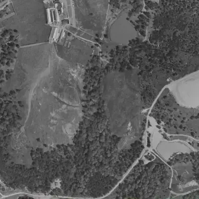
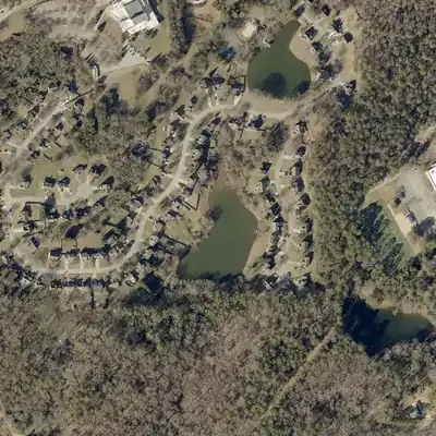
Mathis Lake (Lower) did not exist in 1955. The 1955 photo shows a forested gully and pasture. By 1968 a full lake sits behind a tall earth dam, so the dam was built between those years.
- First seen
- Absent in 1955; a full lake with a fresh bare dam strip appears in 1968.
- Dam in the lidar
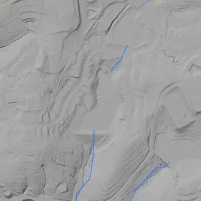
- A straight earth dam closes the south end. Lidar shows it about 42 feet high at the old stream channel, about 32 feet elsewhere. The level crest is about 10 feet above the lake and roughly 370 feet long. No breach. A spillway swale at the east end sits about 4 to 5 feet above the lake.
Read from aerial photos taken between 1940 and 2026 and from DeKalb County 2024 lidar, then checked by a second reading. How the photos were read.
Depth
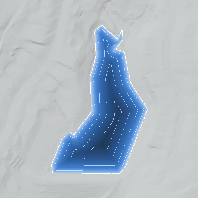
Modeled from the shoreline shape and the dam inventory’s average depth: deepest point about 23 ft. Treat it as an estimate; no survey of the lake bottom was found. How depth is estimated.
History
Mathis Lake is a roughly 4-acre private lake owned by the Renaissance Lakes community association, southeast of Decatur near Columbia and Rainbow Drives. The National Inventory of Dams lists a 37-foot, 375-foot-long earth dam, completed 1949 (a year the NID often estimates), with Norris Const. Co. as designer, rated low hazard. The name may come from the Mathis family, whose dairy was at 3181 Rainbow Drive, about 0.4 mile north, but no document found says so. The surrounding subdivision is listed as built 1991-1996. Beyond the NID entry, the record is thin. 1234
Who built it
Not documented. NID gives 1949 as the completion year and Norris Const. Co. as designer, with purpose 'Fire Protection, Stock, Or Small Fish Pond', a category consistent with a farm pond of the period. The stream is listed as 'Unknown'; the USGS hydrography layer shows unnamed flowlines within 100 m and Shoal Creek within about 400 m. The lake shares a surname with the Mathis Dairy, which later sources place on Rainbow Drive (address 3181 Rainbow Dr) and date to between 1916 and about 1922, but a link is an inference from the name and proximity, not a sourced fact. 1524678
Timeline
- c. 1916-1922R.L. Mathis starts a dairy in DeKalb County. Sources disagree on the start: 1916 (Atlanta 100), 1917 (Past Tense GA), or 'about 1920-22' (family oral history). Later sources place the dairy on Rainbow Drive. Uncertain 678
- 1927A Georgia Archives 'Vanishing Georgia' photograph, dated 1927, is captioned 'Mathis Dairy Barn, located on Rainbow Drive.' 10
- 1928Mathis Dairy begins meeting Certified Milk Standards, according to The Atlanta 100; the family oral history also dates the dairy's certification to 1928. 68
- 1949NID lists this dam as completed, with Norris Const. Co. as designer. The NID year is often an estimate, so treat it as approximate. Uncertain 1
- 1991-1996Renaissance Lakes subdivision listed as built around the lake, west of Columbia Drive and south of Rainbow Drive (real-estate listing site, not a plat). Likely 3
- 1995Mathis Dairy is sold, according to The Atlanta 100. The DeKalb History Center parks collection also holds a 1995 folder titled 'Mathis Dairy - Soapstone'; its contents are not examined. Likely 611
- February 9, 1996The Atlanta Journal-Constitution runs 'Where the kids met the cow' by Charles Watson; the DeKalb History Center keeps it in its R. L. Mathis Dairy subject file. 12
- September 1, 2005Last recorded state inspection of the dam in the NID. 1
Names
- Mathis Lake Dam (Lower)
- Dam name in the National Inventory of Dams; the '(Lower)' suffix pairs it with Exchange Park Lake Dam (Upper), about 240 m to the east. 1
The dam
NID: earth dam, 37 ft high (hydraulic height 24 ft), 375 ft long, 4 surface acres, 44 acre-ft normal and 55 acre-ft maximum storage, uncontrolled spillway and outlet. Hazard Low, condition 'Not Rated', state-jurisdictional (not state-regulated), last inspected 09/01/2005 on a 5-year cycle, record updated 04/20/2021. Georgia defines a dam as a barrier 25 ft or more high or holding 100 acre-ft or more; the state says only Category I dams (probable loss of life) are regulated, and Category II dams have no regulatory requirements but are re-inventoried at least every 5 years. NID's Low hazard suggests Category II, but that mapping is an inference. No rebuild or contract records found. 19
- Year in the inventory
- 1949
- Dam height
- 37 ft
- Surface
- 4 acres
- Average depth
- about 11 ft
- Owner type
- Private
Figures from the U.S. Army Corps of Engineers’ National Inventory of Dams. Its “year” is often a rebuild or survey date, and average depth is storage divided by area.
Around the lake
Water
NID gives the stream as 'Unknown'. USGS NHD shows unnamed flowlines within 100 m, a Shoal Creek flowline within about 400 m, and three small mapped ponds (0.008 to 0.014 sq km) within about 500 m, one more than the NID lists. The lake likely sits on a Shoal Creek headwater tributary, but drainage is not confirmed.
Visiting
Getting there
Private. NID lists the Renaissance Lakes Community as owner; a real-estate listing says the subdivision has a community lake with dock and fishing for residents. No public access found.
What you can see
Unverified. No public viewpoint, marker, or ruins are documented. A visitor might be able to see the lake from public streets in the subdivision, but this was not confirmed. Please respect the private property.
Look, don’t dig. Parks, cemeteries and preserves are off limits to digging and collecting, and private land needs the owner’s permission to enter.
Open questions
- Is Mathis Lake named for the Mathis Dairy family, and did the dairy build it (possibly in 1949)?
- What stream does it impound, and is it linked to the Exchange Park lake by a shared creek?
- Who is 'Norris Const. Co.' and who commissioned the dam?
- Was the lake enlarged or rebuilt when Renaissance Lakes was platted in the 1990s?
- NHD maps a third small pond in the same cluster that the NID does not list; which pond is which?
- What is in the DeKalb History Center's 1995 'Mathis Dairy - Soapstone' parks folder?
Know something? Write to hello@historyunderfoot.org. Family papers, photos and deeds often settle these.
Where to look next
- DeKalb History Center oral-history transcript: Mathis family discussing Mathis Dairy and Rainbow Drive (catalog 2012.3.25); also the September 2002 'DeKalb's Rural Roots' oral history (2012.3.131), whose catalog description lists Mathis Dairy and Rainbow Drive. Ask staff to check for mentions of ponds or land sales. (DeKalb History Center Archives)
- Subject File 'Agriculture-Dairy Farms: R. L. Mathis Dairy' and the AJC article 'Where the kids met the cow' by Charles Watson, February 9, 1996. (DeKalb History Center Archives)
- UGA 1938-40 DeKalb aerial photos and the 1949 GSU Atlanta aerials: check for a pond, dam, or Mathis farm buildings at 33.7056, -84.2578 before the 1990s subdivision. (UGA Map & Government Information Library; Georgia State University Library)
- USGS topographic quadrangle editions covering the site (1950s to 1990s): compare pond outlines before and after subdivision. (USGS Historical Topographic Map Collection (topoView))
- Renaissance Lakes subdivision plat and any dam or lake easement in DeKalb Superior Court plat books. (DeKalb County Clerk of Superior Court, Real Estate Records)
- Georgia EPD Safe Dams file for state ID 044-058-00797 (inspection notes, any rebuild permit). (Georgia EPD Safe Dams Program (open records request))
Sources
- National Inventory of Dams, national CSV (records GA03918 and GA03920), data last updated 2026-9-23 U.S. Army Corps of Engineers
- U.S. Census Geocoder, address lookups (2771 Columbia Dr, 3181 Rainbow Dr, Rainbow Dr & Columbia Dr, Decatur GA) and coordinate-to-geography lookups U.S. Census Bureau
- Renaissance Lakes in Decatur, GA (subdivision overview: built 1991-1996, west of Columbia Dr and south of Rainbow Dr, lake and dock) Homes by Marco (real-estate listing site)
- Mathis Dairy Exhibit @ Old Court House (identifies R.L. Mathis Dairy at 3181 Rainbow Drive) Next Stop...Decatur (blog)
- USGS National Hydrography Dataset map service (flowline and waterbody queries near 33.7056, -84.2578) U.S. Geological Survey
- Rosebud and Mathis Dairy The Atlanta 100 (Atlanta magazine/Atlanta History Center project)
- Mathis Dairy and Rosebud-Rainbow Drive, Decatur Past Tense GA
- Transcript of videotape 2012.3.25, Mathis family on Mathis Dairy DeKalb History Center
- Safe Dams Program Frequently Asked Questions Georgia Environmental Protection Division
- Photograph of Mathis Dairy Barn, Decatur, DeKalb County, Georgia, 1927 (Vanishing Georgia; field note 'located on Rainbow Drive') Digital Library of Georgia / Georgia Archives
- DeKalb Parks and Recreation collection finding aid (folders 'Exchange park 1961-1989' and 'Mathis Dairy - Soapstone 1995'; department begun 1955) DeKalb History Center
- No Cattle Left at the Ranch (Home): DeKalb's Dairies to Homes (footnote cites AJC, Feb 9, 1996, 'Where the kids met the cow', Subject File: R. L. Mathis Dairy) DeKalb History Center