Still here · DeKalb County · Dam inventory GA01311
Scott Candler Reservoir #1
Raw-water storage reservoir for DeKalb County's Scott Candler water plant off Winters Chapel Road, held by a 55-foot earth dam and filled from the Chattahoochee.
From the air
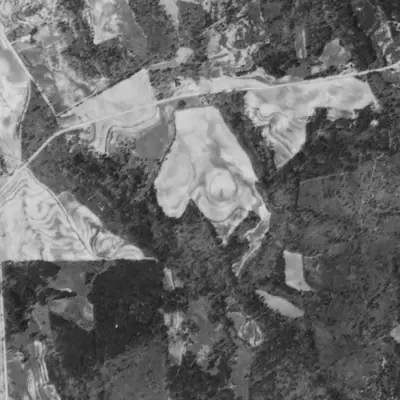
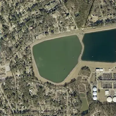
Before 1981 the reservoir was smaller. A marshy, wooded north arm was regraded and flooded, and the shoreline has not changed since.
- First seen
- Not there in 1940, when the site was terraced farm fields and a wooded creek valley. A full reservoir, with its twin next door, appears in 1955.
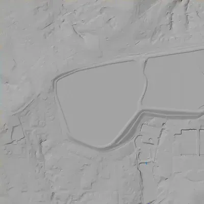
- Dam in the lidar
- The lidar shows a ring embankment with a level crest near 1,056 feet, about 7 feet above the water. It is tallest on the southeast side, facing the old plant, at roughly 67 to 70 feet. It drops to 20 to 27 feet on the south. On the west and north it is only a bench cut into higher ground. No breach or spillway is visible.
Read from aerial photos taken between 1940 and 2026 and from DeKalb County 2024 lidar, then checked by a second reading. How the photos were read.
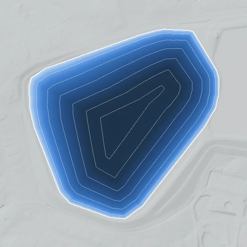
Depth
Modeled from the shoreline shape and the dam inventory’s average depth: deepest point about 34 ft. Treat it as an estimate; no survey of the lake bottom was found. How depth is estimated.
History
Scott Candler Reservoir #1 is part of the raw-water storage at DeKalb County's Scott Candler Water Treatment Plant. A 1940 newspaper report, as quoted in a local-history column, described a storage lake and filter plant between Doraville and Dunwoody; construction began in 1941 under Commissioner Scott Candler, and the original plant dates to 1942. The NID lists a 55-foot earth dam, 3,350 feet long, holding about 1,296 acre-feet, rated High hazard and Satisfactory in February 2021. DeKalb's raw water comes from the Chattahoochee via a pumping station in north Fulton County. The reservoirs were expanded around 2002-2004, and the old filter plant is now slated for demolition. 123456789
Who built it
DeKalb County built it as raw-water storage for the county waterworks. Scott Candler began the project in 1933 as mayor of Decatur, and construction started in 1941, funded by $1 million in water certificates, $500,000 in federal money and WPA labor. A September 18, 1940 Atlanta Constitution article (headline 'DeKalb County sells bonds for water system'), as quoted in a 2022 column, said a storage lake and filter plant would be built between Doraville and Dunwoody. Some sources date the water system to 1940 and others the start of construction to 1941. The reservoirs appear to be off-stream storage fed by pumping from the Chattahoochee; the NID lists the stream as 'Unknown', and USGS flowlines named Nancy Creek run within about 1.5 km, which is a map observation only. The NID designer field reads 'ARTHUR PUGH'; his role is not documented in the sources found. 121056711
Timeline
- 1933Scott Candler, then mayor of Decatur, begins working on a county waterworks project. 2
- September 18, 1940Per a 2022 column quoting an Atlanta Constitution article on DeKalb bond sales, a storage lake and filter plant would be built between Doraville and Dunwoody. The original article was not seen. Likely 6
- 1941Construction of the DeKalb waterworks begins, funded by $1 million in water certificates, $500,000 in federal money and WPA workers. Two sources date the new water system itself to 1940. 2106
- 1942The original Scott Candler water treatment plant is built, according to DeKalb County's 2024 capital-improvement presentation and a county commissioner's article. 128
- 1942Rough Draft Atlanta dates the first Scott Candler reservoir dam to 1942. Which basin is not stated. Likely 3
- June 12, 1943Georgia Supreme Court rules for DeKalb over Atlanta's claim to Druid Hills water customers. Lines already laid to Druid Hills were switched on a few weeks later. 2
- 1953Rough Draft Atlanta dates a second reservoir dam to 1953. Which basin is not stated. Likely 3
- May 2002A trade-press report from August 2002 says a third reservoir was added in May 2002; Archer Western Contractors was hired in June 2002 as general contractor for the $152 million new plant. 4
- 2004Stratus's $48 million reservoir and waterline project completes; raw-water storage grows from about 200 million to about 1 billion gallons. Rough Draft also dates a dam expansion to 2004. 35
- 2005A contractor-listing page says the original filter plant was decommissioned in 2005; the 2002 report had targeted 2005 for the new plant's completion. Sources conflict with 2007. Uncertain 49
- 2007DeKalb's 2024 presentation says a completely new treatment plant was built in 2007, with remnants of the 1942 plant still used for pumping. 12
- 2012State inspection information cited in a 2015 article called for relatively minor repairs and maintenance. 3
- February 4, 2021NID records the latest state inspection and a Satisfactory condition assessment for the dam. 1
- March 2026DeKalb design-build RFP 5941817 (bid date March 5, 2026; listed start April 2, 2026) covers demolishing the old filter facility and building a high-service pump station and two 10-million-gallon clearwells. A county plan anticipates this work for 2026-2029. 913
- July 2026A news summary says a $233 million Scott Candler plant improvement request came before a DeKalb watershed committee on July 7, 2026, and its presentation was postponed a day. Likely 14
Names
- Scott Candler Reservoir Dam #1
- Official National Inventory of Dams (NID) name; the state dam record number is 044-024-00377. 1
- DeKalb County Water Works
- GNIS name on the USGS hydrography reservoir polygon at this spot (the project's NID extract also carries it as an alternate name). It is a utility name, not a historic lake name. 11
- Scott Candler Filter Plant / storage lake
- Project language for the treatment works and the raw-water storage beside it. A 1940 Atlanta Constitution report, as quoted in a 2022 local-history column, described 'a storage lake and filter plant' between Doraville and Dunwoody; Stratus Engineering later called the works the 'Scott Candler Filter Plant'. 56
The dam
NID: earth dam, 55 ft high, 3,350 ft long, maximum storage 1,296 acre-feet (about 420 million gallons), surface area 55 acres, uncontrolled spillway and outlet, owner DeKalb County, regulated by the Georgia Safe Dams Program. Hazard: High. Condition: Satisfactory, last inspected and assessed February 4, 2021 (2-year inspection cycle; NID record updated April 2021, so newer state inspections may exist). NID's year completed, 1940, conflicts with other sources: construction began in 1941, the plant dates to 1942, and Rough Draft Atlanta dates reservoir dams to 1942 and 1953 with an expansion in 2004. Stratus Engineering provided engineering for a new reservoir and a redesign of the existing reservoirs, completed 2004 at $48 million, raising raw-water storage from about 200 million to about 1 billion gallons. A 2015 Rough Draft article said the latest reported information, from 2012, called for relatively minor repairs and maintenance. 1358
- Year in the inventory
- 1940
- Dam height
- 55 ft
- Surface
- 55 acres
- Owner type
- Local Government
Figures from the U.S. Army Corps of Engineers’ National Inventory of Dams. Its “year” is often a rebuild or survey date, and average depth is storage divided by area.
Around the lake
Water
The Chattahoochee River is the source of DeKalb's drinking water, pumped from a raw-water station in north Fulton County. Whether it reaches these basins by pipe or otherwise is not spelled out in the county page; the NID stream for this dam is 'Unknown'.
Before 1861
The reservoirs date to 1941 and later, so no pre-1860 mills or roads tied to this exact site are documented in the sources found.
Visiting
Getting there
Owned and operated by DeKalb County's Department of Watershed Management as part of a working water treatment facility. No public park, trail or visitor program was found in the sources reviewed.
What you can see
The plant and reservoir embankments are working utility infrastructure; Rough Draft Atlanta (2015) places the dam on Peeler Road and the plant address is on Winters Chapel Road. No historical marker was found in the sources reviewed. The 1942 filter plant is slated for demolition under a 2026 project, so what survives may change.
Look, don’t dig. Parks, cemeteries and preserves are off limits to digging and collecting, and private land needs the owner’s permission to enter.
Open questions
- Which of the two older basins was built in 1942 and which in 1953, and how the third basin (NID GA00063, listed under Gwinnett County) relates to them.
- Which stream valley, if any, each reservoir dam originally crossed; NID leaves the stream 'Unknown' and 1940s topo maps have not been checked.
- Who Arthur Pugh, the NID designer, was and what he designed.
- Whether the 2002-04 project raised the original dams or built new embankments, since NID's 55-ft height and 3,350-ft length are current figures.
- Whether the CourtListener opinion in City of Atlanta v. DeKalb County (Justice Bell; concerns Druid Hills water mains; date not shown in the excerpt) is the June 12, 1943 ruling.
- Whether the old filter plant was decommissioned in 2005 or later, and whether demolition has started.
Know something? Write to hello@historyunderfoot.org. Family papers, photos and deeds often settle these.
Where to look next
- Atlanta Constitution, September 18, 1940 article 'DeKalb County sells bonds for water system' (as cited in the column) (Atlanta Constitution archive (newspaper databases via Atlanta-Fulton Public Library); cited in an Appen Media column)
- DeKalb New Era, 1885-1955, coverage of the waterworks, the Druid Hills dispute and reservoir construction (Microfilm at the Decatur Library, per the DeKalb History Center; archives visits by appointment)
- City of Atlanta v. DeKalb County, Georgia Supreme Court opinion on Druid Hills water mains (date to confirm) (CourtListener)
- 1930s-40s aerial photographs of DeKalb County, showing the valleys before 1941 construction (check what is available) (University of Georgia Libraries Map and Government Information Library / Digital Library of Georgia)
- USGS 7.5-minute topographic map editions covering the Doraville/Chamblee area, pre-1941 through later decades, to see the basins before and after the 1953 and 2004 work (confirm sheet name in TopoView) (USGS TopoView)
- Georgia Safe Dams file for dam 044-024-00377 (inspection reports, permits, design drawings, Arthur Pugh) (Georgia EPD Safe Dams Program open records request)
- 2002-2004 DeKalb Board of Commissioners agendas and the Stratus contract for the new reservoir; RFP 5941817 documents (DeKalb County Legistar and procurement portal)
Sources
- National Inventory of Dams records GA01311, GA00227, GA00063 (ArcGIS feature service mirror of USACE NID) U.S. Army Corps of Engineers (NID)
- Single-Family Residential Development in DeKalb County, 1945-1970 DeKalb History Center
- State monitors 'high-hazard' dams Rough Draft Atlanta
- Dekalb County (GA) $152 million Water Plant Construction Nears Beginning Wastewater Digest
- DeKalb County Scott Candler Reservoir and Waterlines Stratus Engineering
- Opinion: Local WPA Projects during the Great Depression Appen Media
- Your Water Source DeKalb County Watershed Management
- Strengthening DeKalb's Water Infrastructure DeKalb County Commissioner Robert Patrick
- RFP D/B - Scott Candler Water Treatment Plant Demolition and New Clearwells and High Service Pump Station (RFP 5941817) ConstructConnect
- Post War DeKalb County, a Shiny Industrial Future DeKalb History Center
- USGS National Hydrography Dataset, Waterbody and Flowline layers (queried near 33.937, -84.278) U.S. Geological Survey
- CIP 2024 Scott Candler Water Treatment Plant Improvements (Presentation to BOC, June 20, 2024) DeKalb County Government
- DeKalb County proposes $4.27B plan to upgrade water and sewer infrastructure Government Market News
- Watershed items: ... $233M Scott Candler presentation postponed Citizen Portal