Status unknown · City of Atlanta · Location approximate
Moore's Mill and millpond
A mid-1800s sawmill and gristmill dam on Peachtree Creek whose pond Union pickets drained by wrecking the flume on July 19, 1864.
From the air
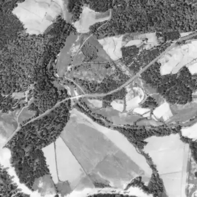
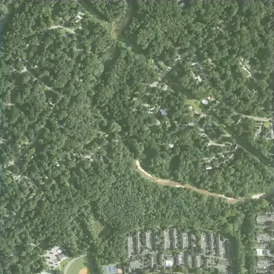
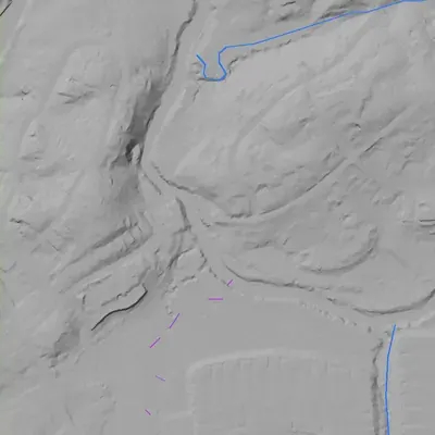
No millpond shows up in any aerial from 1940 to 2013, and the lidar finds no dam. If Moore's Mill had a pond here, it was gone before the first photo.
- Gone
- Any pond was already gone by 1940, the date of the earliest aerial photo, if one was ever at this crossing.
- Dam in the lidar
- No dam was found. The lidar shows no embankment along Peachtree Creek near the Moore's Mill Road bridge, in the narrow stretch just downstream, or in the gorge beyond. The creek bed falls smoothly about 3.5 feet with no step. The creek is flattened in the model, so a low or removed dam could still be hidden.
Read from aerial photos taken between 1940 and 2026 and from USGS 3DEP lidar, then checked by a second reading. How the photos were read.
History
Thomas Moore built a sash sawmill and a gristmill on Peachtree Creek in 1854, served by a dam that held back Peachtree and Woodall creeks. The mills burned about 1858, were rebuilt, and ran until 1901. In the Atlanta Campaign, Union troops of the 14th Corps reached the creek here; on the night of July 19, 1864, pickets of the 10th Michigan occupied the mill and destroyed the flume, emptying the millpond. The marker says the property was badly damaged but not destroyed. The record found is two 1956 state markers. No dam records, plats, or photos of the pond turned up, so its later fate is unsettled. 12
Who built it
Thomas Moore (1828-1914) built a sash sawmill and, lower down, a gristmill in 1854. A flume connected them to a dam that impounded the waters of Peachtree and Woodall creeks; the ford was below the dam. The marker does not say why the site was chosen beyond milling. Sawing and grinding are the implied purposes, and the gristmill was supplying Confederate forces in 1864. 1
Timeline
- 1854Thomas Moore builds a sash sawmill and a gristmill on Peachtree Creek, joined by a flume to a dam impounding Peachtree and Woodall creeks. 1
- c. 1858The mills burn during what the marker calls a 'political upheaval'. The marker does not explain the cause. 1
- After c. 1858The mills are rebuilt and operate until 1901. The rebuild date, and whether the dam and pond changed, are not stated. 1
- 1864As the Federal army approaches, the Moore family refugees south. B. F. Mauldin is left in charge of the gristmill, which was supplying Confederate forces; the invaders send him north as a prisoner. 1
- July 19, 1864Morgan's brigade (Davis's division, 14th Corps) is posted right of Dilworth's brigade to support a crossing of Peachtree Creek at its junction with Green Bone Creek, under Confederate fire from a bluff south of the mill. 2
- Night of July 19, 1864Pickets of the 10th Michigan occupy the mill and destroy the flume, emptying the millpond. 2
- July 20, 1864Mitchell's brigade, west of Nancy's Creek, outflanks the Confederates on the bluff and forces them out; Morgan's brigade crosses at the ford. The Battle of Peachtree Creek is fought the same day. 24
- 1864The marker says the mill property was considerably damaged but not destroyed. 1
- 1901The mills' last year of operation, according to marker 060-64. 1
- 1956The Georgia Historical Commission markers 060-64 (Moore's Mill) and 060-65 (Battle at Moore's Mill) are erected on Moore's Mill Road near Margaret Mitchell Drive. 125
Names
The dam
The dam held back Peachtree and Woodall creeks and fed the mills through a flume (marker 060-64). No height, construction detail, spillway, or engineering record was found. A National Inventory of Dams query around the marker point found no matching dam (source 6), and the Georgia EPD Safe Dams listing was not checked. Marker 060-65 names the flume, not the dam, as what Union pickets destroyed in 1864; it does not say whether the dam itself was damaged. 123
Around the lake
Water
The dam impounded Peachtree Creek and Woodall Creek, and the ford lay below the dam. Green Bone Creek joins Peachtree Creek at the crossing described on marker 060-65. The record found gives no flood or drawdown history for this site.
Civil War
Yes, directly. On July 19-20, 1864, Union 14th Corps troops (Davis's division) faced Confederate fire from a bluff south of the mill and crossed at the ford once outflanked. The 10th Michigan's pickets destroyed the flume and drained the pond. The Battle of Peachtree Creek was fought on July 20.
Before 1861
The mills date to 1854, before the war, and the marker says they burned about 1858 and were rebuilt. A ford lay below the dam. No pre-1860 land lot, road, or deed record was found.
Visiting
Today
Peachtree Creek floodplain below Moores Mill Road.
Getting there
Not confirmed. The two markers are recorded on Moore's Mill Road east of Peachtree Creek, near Margaret Mitchell Drive (Fulton County, Atlanta), but their current presence was not re-verified for 2026. Whether the pond, dam remains, or a public path exist today was not verified. Do not assume public access to the creek bank; check the road right-of-way and property lines first.
What you can see
The two state historical markers by the roadside, if still in place. Nothing found in the record confirms any surviving dam, flume, mill foundation, or standing pond. The mill structures stood about 300 yards downstream of the marker.
What to look for
The dam line and flume route below the marker; the pond flat upstream at the Peachtree-Woodall confluence.
Look, don’t dig. Parks, cemeteries and preserves are off limits to digging and collecting, and private land needs the owner’s permission to enter.
Open questions
- Where exactly did the dam stand? The unit point is the marker, and the marker puts the mill buildings 300 yards downstream of it.
- What was the 'political upheaval' about 1858 that burned the mills?
- Was the dam rebuilt with the mills after 1858, or after the 1864 flume damage, and how big was the pond?
- When and how did the dam fail or get removed after operations ended in 1901?
- Wikipedia's mill list gives an 1828 founding date, which conflicts with the marker's 1854; which sources did it use?
- Is the millpond site still traceable in the creek floodplain, and is any of it on public land?
- Is the state Safe Dams (Georgia EPD) listing silent on this site as well as the NID?
Know something? Write to hello@historyunderfoot.org. Family papers, photos and deeds often settle these.
Where to look next
- Georgia Historical Society marker files for 060-64 and 060-65 (1956 text research files may cite sources) (Georgia Historical Society, Savannah)
- 1860 federal census Schedule of Manufactures and Agriculture for Thomas Moore, giving mill output and water power in the 1860 census year (Fulton County, Georgia, 1860 industrial schedules; NARA and state archives copies)
- Union army field maps and Official Records reports for Davis's division (14th Corps) and the 10th Michigan, July 19-20, 1864, which may show the mill, dam and ford (Official Records, Series 1, vol. 38; Library of Congress Atlanta Campaign maps)
- 1949 aerial photographs of Atlanta, to look for a pond outline or dam scar on the creek (Georgia State University Library, Aerial Photography collection)
- Historic USGS topographic quadrangles (Northwest Atlanta / Marietta editions, early to mid 1900s), which may label a mill or pond (USGS Historical Topographic Map Collection (topoView))
- Newspaper items on the Moore family, the 1901 end of operations, and later flooding or road naming (Georgia Historic Newspapers, Digital Library of Georgia)
- Deeds and plats for the Moore tract and later subdivisions along Moore's Mill Road (Fulton County Superior Court Clerk deed and plat records)
- Marker record and photographs for 'Battle at Moore's Mill' (Historical Marker Database entry m=35687, listed under Buckhead; page not fetched in this check because of rate limiting) (Historical Marker Database)
Sources
- Moore's Mill (marker 060-64) Georgia Historical Society
- Battle at Moore's Mill (marker 060-65) Georgia Historical Society
- National Inventory of Dams public feature service (spatial query near 33.8264, -84.4424) U.S. Army Corps of Engineers
- Battle of Peachtree Creek Wikipedia
- Georgia Historical Markers feature service (records for 060-64 and 060-65, coordinates 33.8263813, -84.4423894, erected 1956) Georgia Historical Society (ArcGIS)
- Historic mills of the Atlanta area Wikipedia